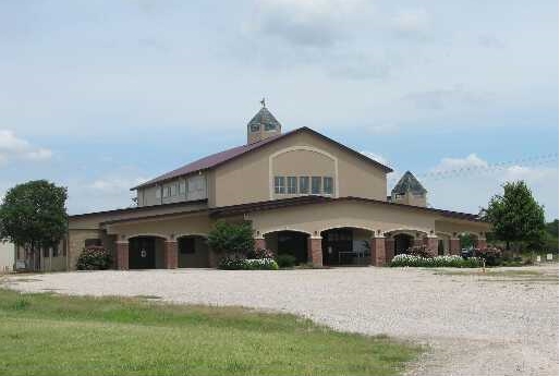
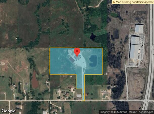
Property Record
2281 W 171St St S, Glenpool, OK 74033
NEARBY LISTINGS FOR SALE OR LEASE
Property Detail
2281 W 171St St S
97227-72-27-59470
Unplatted
Medicalbuilding
BEG NWC SW SE TH E1319.42 S663.33 W449.95 S660.58 W60 N300 W150 N361.34 W659.62 N659.35 TO POB SEC 27 17 12 22.188ACS
X
Tulsa
40143C0420K
Oklahoma
2023
22.19 AC
2024
South Tulsa
007705
Tulsa
27,782 SF
Tulsa, OK
DEMOGRAPHICS near 2281 W 171St St S
1 Mile
3 Mile
5 Mile
2024 Total Population
337
8,703
23,437
2029 Population
344
8,914
24,073
Pop Growth 2024-2029
+ 2.08%
+ 2.42%
+ 2.71%
Average Age
38
36
37
2024 Total Households
117
2,972
8,264
HH Growth 2024-2029
+ 1.71%
+ 2.46%
+ 2.73%
Median Household Inc
$112,500
$80,479
$74,338
Avg Household Size
2.90
2.90
2.80
2024 Avg HH Vehicles
3.00
2.00
2.00
Median Home Value
$312,500
$198,653
$206,560
Median Year Built
1997
1999
1996
Nearby Places
- Restaurants
- Banks
- Shops
- Fitness
- Groceries
PUBLIC TRANSPORTATION
AIRPORT
Tulsa International
DRIVE
WALK
Distance
Tulsa International
37 min
26.7 mi
Freight Ports
Tulsa Port Of Catoosa
DRIVE
WALK
Distance
Tulsa Port Of Catoosa
46 min
35.4 mi
Nearby Properties
Address
Land Use
TOTAL SIZE
Lot Size
Zoning
Address
Land Use
TOTAL SIZE
Lot Size
Zoning
52,441 SF
12.79 AC
CS
Address
Land Use
TOTAL SIZE
Lot Size
Zoning
49,735 SF
14.35 AC
CG
Address
Land Use
TOTAL SIZE
Lot Size
Zoning
116,016 SF
54.80 AC
CG
Address
Land Use
TOTAL SIZE
Lot Size
Zoning
28,761 SF
9.71 AC
RS1
Address
Land Use
TOTAL SIZE
Lot Size
Zoning
6,702 SF
3.63 AC
AG
Address
Land Use
TOTAL SIZE
Lot Size
Zoning
38,476 SF
18.68 AC
CG
Address
Land Use
TOTAL SIZE
Lot Size
Zoning
68,298 SF
28.60 AC
CG
Address
Land Use
TOTAL SIZE
Lot Size
Zoning
18,078 SF
14.73 AC
IL
Address
Land Use
TOTAL SIZE
Lot Size
Zoning
16,310 SF
10.28 AC
AG
Address
Land Use
TOTAL SIZE
Lot Size
Zoning
16,068 SF
0.80 AC
CG
Address
Land Use
TOTAL SIZE
Lot Size
Zoning
32,408 SF
6.25 AC
AG
Address
Land Use
TOTAL SIZE
Lot Size
Zoning
33,128 SF
1.83 AC
RM2
Address
Land Use
TOTAL SIZE
Lot Size
Zoning
107,943 SF
8.49 AC
PUD
Address
Land Use
TOTAL SIZE
Lot Size
Zoning
5,075 SF
1.45 AC
CS
Address
Land Use
TOTAL SIZE
Lot Size
Zoning
9,950 SF
4.76 AC
RS2
Address
Land Use
TOTAL SIZE
Lot Size
Zoning
197,644 SF
32.39 AC
IL
Address
Land Use
TOTAL SIZE
Lot Size
Zoning
5,580 SF
4.55 AC
RD
Address
Land Use
TOTAL SIZE
Lot Size
Zoning
6.76 AC
AG
Address
Land Use
TOTAL SIZE
Lot Size
Zoning
2,400 SF
19.62 AC
Address
Land Use
TOTAL SIZE
Lot Size
Zoning
36,000 SF
1.90 AC
AG
Address
Land Use
TOTAL SIZE
Lot Size
Zoning
30,160 SF
2.74 AC
CS
Address
Land Use
TOTAL SIZE
Lot Size
Zoning
7,340 SF
0.24 AC
RS3
Address
Land Use
TOTAL SIZE
Lot Size
Zoning
840 SF
10.43 AC
AG
Address
Land Use
TOTAL SIZE
Lot Size
Zoning
5,800 SF
1.86 AC
CS
Address
Land Use
TOTAL SIZE
Lot Size
Zoning
23,605 SF
2.23 AC
CS
Address
Land Use
TOTAL SIZE
Lot Size
Zoning
72,456 SF
3.77 AC
RM2
Address
Land Use
TOTAL SIZE
Lot Size
Zoning
108,000 SF
8.81 AC
AG
Address
Land Use
TOTAL SIZE
Lot Size
Zoning
83,598 SF
19.93 AC
IL
Address
Land Use
TOTAL SIZE
Lot Size
Zoning
27,000 SF
2.20 AC
CS
The World's #1 Commercial Real Estate Marketplace
Connect with us
© 2025 CoStar Group
The information above has been obtained from sources believed reliable. While we do not doubt its accuracy we have not verified it and make no guarantee, warranty or representation about it. It is your responsibility to independently confirm its accuracy and completeness. Any projections, opinions, assumptions, or estimates used are for example only and do not represent the current or future performance of the property. The value of this transaction to you depends on tax and other factors which should be evaluated by your tax, financial, and legal advisors. You and your advisors should conduct a careful, independent investigation of the property to determine to your satisfaction the suitability of the property for your needs.