Property Record
401 Hunter Pl, Manhattan, KS 66503
NEARBY LISTINGS FOR SALE OR LEASE
-
-
View all Manhattan listings for sale on LoopNet.com
Property Detail
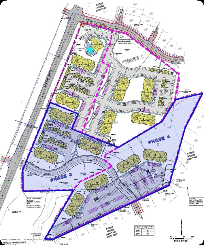
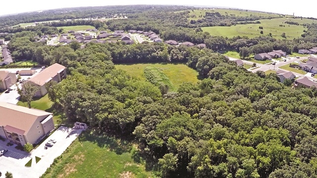
401 Hunter Pl
Manhattan, KS
Scenic Woods
215-15-0-20-06-010.00-0
SCENIC WOODS, LOT 6, ACRES 4.48
Gardenaptcourtapt5plusunits
Riley
X
Kansas
20161C0342G
6
2023
12.40 AC
2024
Kansas Area
001302
Other Market Areas
82,503 SF
DEMOGRAPHICS near 401 Hunter Pl
1 Mile
3 Mile
5 Mile
2024 Total Population
3,863
28,138
54,656
2029 Population
3,870
28,119
54,707
Pop Growth 2024-2029
+ 0.18%
(0.07%)
+ 0.09%
Average Age
35
35
33
2024 Total Households
1,551
11,366
21,681
HH Growth 2024-2029
0.00%
(0.19%)
+ 0.02%
Median Household Inc
$111,764
$89,596
$58,028
Avg Household Size
2.40
2.20
2.20
2024 Avg HH Vehicles
2.00
2.00
2.00
Median Home Value
$321,683
$264,271
$238,017
Median Year Built
2006
1987
1982
Nearby Places
- Restaurants
- Banks
- Shops
- Fitness
- Groceries
PUBLIC TRANSPORTATION
AIRPORT
Manhattan Regional
DRIVE
WALK
Distance
Manhattan Regional
12 min
5.8 mi
Freight Ports
Tulsa Port Of Catoosa
DRIVE
WALK
Distance
Tulsa Port Of Catoosa
340 min
284.9 mi
SALE & LEASE HISTORY
LISTING DATE
SALE/LEASE

Sep 24, 2016
For Sale
Nearby Properties
Address
Land Use
TOTAL SIZE
Lot Size
Zoning
Address
Land Use
TOTAL SIZE
Lot Size
Zoning
125.53 AC
U
Address
Land Use
TOTAL SIZE
Lot Size
Zoning
69,440 SF
27.76 AC
U
Address
Land Use
TOTAL SIZE
Lot Size
Zoning
347,291 SF
21.20 AC
R
Address
Land Use
TOTAL SIZE
Lot Size
Zoning
126,616 SF
33.30 AC
R1
Address
Land Use
TOTAL SIZE
Lot Size
Zoning
71,182 SF
11.80 AC
R
Address
Land Use
TOTAL SIZE
Lot Size
Zoning
91,968 SF
5.69 AC
PUD
Address
Land Use
TOTAL SIZE
Lot Size
Zoning
89,898 SF
5.48 AC
R3
Address
Land Use
TOTAL SIZE
Lot Size
Zoning
56,522 SF
17.60 AC
ROW
Address
Land Use
TOTAL SIZE
Lot Size
Zoning
71,899 SF
5.50 AC
R
Address
Land Use
TOTAL SIZE
Lot Size
Zoning
52,651 SF
15.28 AC
R
Address
Land Use
TOTAL SIZE
Lot Size
Zoning
32,402 SF
5.76 AC
R
Address
Land Use
TOTAL SIZE
Lot Size
Zoning
67,276 SF
9 AC
R
Address
Land Use
TOTAL SIZE
Lot Size
Zoning
64,310 SF
9.64 AC
R
Address
Land Use
TOTAL SIZE
Lot Size
Zoning
37,416 SF
0.29 AC
R1
Address
Land Use
TOTAL SIZE
Lot Size
Zoning
7,914 SF
5.70 AC
R3
Address
Land Use
TOTAL SIZE
Lot Size
Zoning
58,446 SF
8.45 AC
R
Address
Land Use
TOTAL SIZE
Lot Size
Zoning
1,387 SF
19 AC
R
Address
Land Use
TOTAL SIZE
Lot Size
Zoning
7,320 SF
55.90 AC
R
Address
Land Use
TOTAL SIZE
Lot Size
Zoning
15,411 SF
7.50 AC
R3
Address
Land Use
TOTAL SIZE
Lot Size
Zoning
27,808 SF
21.64 AC
PUD
Address
Land Use
TOTAL SIZE
Lot Size
Zoning
28,453 SF
2.09 AC
R
Address
Land Use
TOTAL SIZE
Lot Size
Zoning
12,875 SF
11.88 AC
U
Address
Land Use
TOTAL SIZE
Lot Size
Zoning
49,087 SF
6.40 AC
C1
Address
Land Use
TOTAL SIZE
Lot Size
Zoning
10,003 SF
2.97 AC
PUD
Address
Land Use
TOTAL SIZE
Lot Size
Zoning
9,226 SF
14.58 AC
PUD
Address
Land Use
TOTAL SIZE
Lot Size
Zoning
8.40 AC
RM
Address
Land Use
TOTAL SIZE
Lot Size
Zoning
15,554 SF
6.95 AC
Address
Land Use
TOTAL SIZE
Lot Size
Zoning
23,712 SF
4.66 AC
C1
Address
Land Use
TOTAL SIZE
Lot Size
Zoning
54,232 SF
1.53 AC
PUD
Address
Land Use
TOTAL SIZE
Lot Size
Zoning
16,638 SF
2.95 AC
PUD
The World's #1 Commercial Real Estate Marketplace
Connect with us
© 2025 CoStar Group
The information above has been obtained from sources believed reliable. While we do not doubt its accuracy we have not verified it and make no guarantee, warranty or representation about it. It is your responsibility to independently confirm its accuracy and completeness. Any projections, opinions, assumptions, or estimates used are for example only and do not represent the current or future performance of the property. The value of this transaction to you depends on tax and other factors which should be evaluated by your tax, financial, and legal advisors. You and your advisors should conduct a careful, independent investigation of the property to determine to your satisfaction the suitability of the property for your needs.