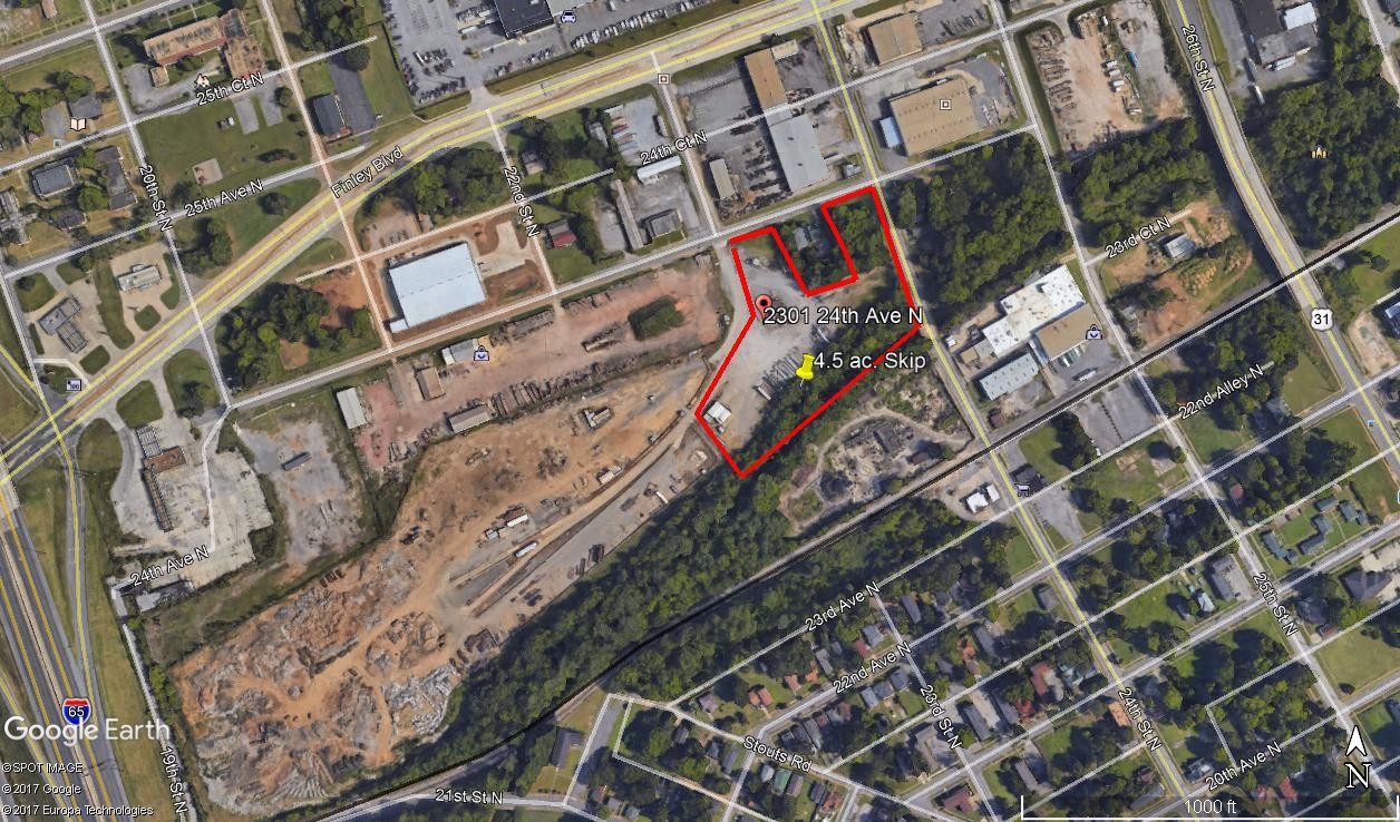
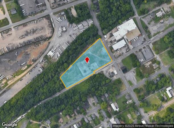
Property Record
2300 24Th St N, Birmingham, AL 35234
NEARBY LISTINGS FOR SALE OR LEASE
Property Detail
2300 24Th St N
Birmingham-Hoover, AL
R.B.C. Resurvey Of 24Th Street
22-00-23-4-003-001.000
Jefferson
Residentialnec
Alabama
AE
3.59 AC
01073C0387H
Fultondale
1,800 SF
Birmingham
DEMOGRAPHICS near 2300 24Th St N
1 Mile
3 Mile
5 Mile
2024 Total Population
7,794
45,270
150,090
2029 Population
7,973
45,795
150,398
Pop Growth 2024-2029
+ 2.30%
+ 1.16%
+ 0.21%
Average Age
43
39
39
2024 Total Households
3,247
19,849
67,017
HH Growth 2024-2029
+ 2.43%
+ 1.42%
+ 0.27%
Median Household Inc
$23,210
$30,111
$41,663
Avg Household Size
2.20
2.00
2.00
2024 Avg HH Vehicles
1.00
1.00
1.00
Median Home Value
$61,593
$81,447
$169,575
Median Year Built
1959
1964
1966
Nearby Places
- Restaurants
- Banks
- Shops
- Fitness
- Groceries
PUBLIC TRANSPORTATION
COMMUTER RAIL
Birmingham (Crescent - Amtrak)
DRIVE
WALK
Distance
Birmingham (Crescent - Amtrak)
4 min
2.2 mi
AIRPORT
Birmingham-Shuttlesworth International
DRIVE
WALK
Distance
Birmingham-Shuttlesworth International
11 min
6.3 mi
Freight Ports
Port of Mobile
DRIVE
WALK
Distance
Port of Mobile
282 min
258.3 mi
SALE & LEASE HISTORY
LISTING DATE
SALE/LEASE

Sep 08, 2021
For Sale
Feb 03, 2022
For Lease
Dec 05, 2017
For Sale
Nearby Properties
Address
Land Use
TOTAL SIZE
Lot Size
Zoning
Address
Land Use
TOTAL SIZE
Lot Size
Zoning
296,284 SF
12 AC
OI
Address
Land Use
TOTAL SIZE
Lot Size
Zoning
305,826 SF
3.68 AC
B4
Address
Land Use
TOTAL SIZE
Lot Size
Zoning
189,447 SF
3.67 AC
B4
Address
Land Use
TOTAL SIZE
Lot Size
Zoning
239,334 SF
4.42 AC
B6
Address
Land Use
TOTAL SIZE
Lot Size
Zoning
224,049 SF
4.33 AC
M1
Address
Land Use
TOTAL SIZE
Lot Size
Zoning
230,441 SF
10.22 AC
M1
Address
Land Use
TOTAL SIZE
Lot Size
Zoning
183,862 SF
9.66 AC
B4
Address
Land Use
TOTAL SIZE
Lot Size
Zoning
334,463 SF
1.92 AC
B4
Address
Land Use
TOTAL SIZE
Lot Size
Zoning
106,144 SF
1.09 AC
B4
Address
Land Use
TOTAL SIZE
Lot Size
Zoning
57,066 SF
0.80 AC
B4
Address
Land Use
TOTAL SIZE
Lot Size
Zoning
94,958 SF
4.47 AC
M1
Address
Land Use
TOTAL SIZE
Lot Size
Zoning
79,458 SF
1.37 AC
B4
Address
Land Use
TOTAL SIZE
Lot Size
Zoning
46,161 SF
1.38 AC
M1-B
Address
Land Use
TOTAL SIZE
Lot Size
Zoning
95,993 SF
3.67 AC
M1
Address
Land Use
TOTAL SIZE
Lot Size
Zoning
229,669 SF
2.75 AC
B4
Address
Land Use
TOTAL SIZE
Lot Size
Zoning
109,411 SF
2.76 AC
B4
Address
Land Use
TOTAL SIZE
Lot Size
Zoning
344,150 SF
42 AC
R5
Address
Land Use
TOTAL SIZE
Lot Size
Zoning
29,136 SF
1.58 AC
B4
Address
Land Use
TOTAL SIZE
Lot Size
Zoning
37,733 SF
0.84 AC
B-4
Address
Land Use
TOTAL SIZE
Lot Size
Zoning
416,477 SF
80 AC
R5
Address
Land Use
TOTAL SIZE
Lot Size
Zoning
109,819 SF
2.90 AC
M2
Address
Land Use
TOTAL SIZE
Lot Size
Zoning
37,640 SF
1.76 AC
B4
Address
Land Use
TOTAL SIZE
Lot Size
Zoning
111,309 SF
1.29 AC
B-4
Address
Land Use
TOTAL SIZE
Lot Size
Zoning
120,768 SF
1.75 AC
B4
Address
Land Use
TOTAL SIZE
Lot Size
Zoning
156,986 SF
1.29 AC
M1
Address
Land Use
TOTAL SIZE
Lot Size
Zoning
1.69 AC
B4
Address
Land Use
TOTAL SIZE
Lot Size
Zoning
97,377 SF
1.63 AC
M1
Address
Land Use
TOTAL SIZE
Lot Size
Zoning
123,136 SF
4.59 AC
M2
Address
Land Use
TOTAL SIZE
Lot Size
Zoning
1.66 AC
M1-B
Address
Land Use
TOTAL SIZE
Lot Size
Zoning
1,666 SF
1.69 AC
M1
The World's #1 Commercial Real Estate Marketplace
Connect with us
© 2025 CoStar Group
The information above has been obtained from sources believed reliable. While we do not doubt its accuracy we have not verified it and make no guarantee, warranty or representation about it. It is your responsibility to independently confirm its accuracy and completeness. Any projections, opinions, assumptions, or estimates used are for example only and do not represent the current or future performance of the property. The value of this transaction to you depends on tax and other factors which should be evaluated by your tax, financial, and legal advisors. You and your advisors should conduct a careful, independent investigation of the property to determine to your satisfaction the suitability of the property for your needs.