Property Record
2300 High Wickham Pl, Louisville, KY 40245

NEARBY LISTINGS FOR SALE OR LEASE
Property Detail
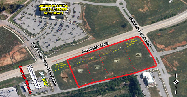
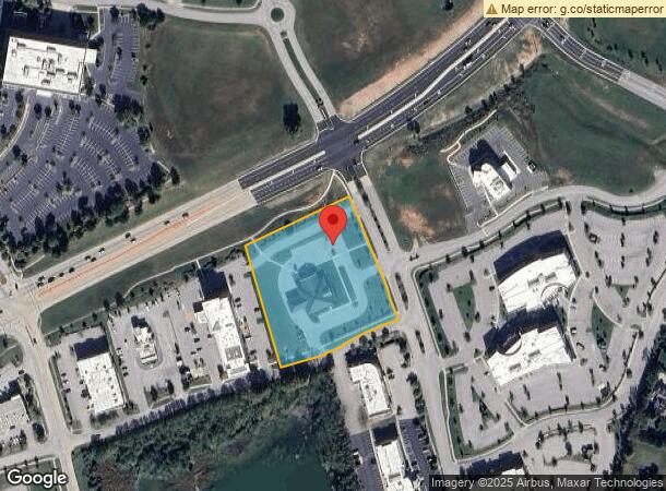
2300 High Wickham Pl
Louisville-Jefferson County, KY-IN
Terra Development Corp
366000100000
TRACT 9A-1 MINOR PLAT DB 11224 X 228, 2.8993 AC +/-
Officebuilding
Jefferson
X
Kentucky
21211C0025D
2.90 AC
2025
Hurstbourne/Lyndon
2025
Louisville
010316
DEMOGRAPHICS near 2300 High Wickham Pl
1 Mile
3 Mile
5 Mile
2024 Total Population
4,303
34,828
109,455
2029 Population
4,362
34,882
109,771
Pop Growth 2024-2029
+ 1.37%
+ 0.16%
+ 0.29%
Average Age
41
41
41
2024 Total Households
1,730
13,373
43,339
HH Growth 2024-2029
+ 1.50%
+ 0.04%
+ 0.06%
Median Household Inc
$124,214
$111,967
$99,468
Avg Household Size
2.50
2.50
2.50
2024 Avg HH Vehicles
2.00
2.00
2.00
Median Home Value
$577,787
$376,725
$332,452
Median Year Built
2005
1998
1994
Nearby Places
Map Layers
Map Styles
 Street
 Aerial
- Restaurants
- Banks
- Shops
- Fitness
- Groceries
PUBLIC TRANSPORTATION
AIRPORT
Louisville Muhammad Ali International
DRIVE
WALK
Distance
Louisville Muhammad Ali International
34 min
21.8 mi
Nearby Properties
Address
Land Use
TOTAL SIZE
Lot Size
Zoning
Address
Land Use
TOTAL SIZE
Lot Size
Zoning
8,200 SF
25.23 AC
Address
Land Use
TOTAL SIZE
Lot Size
Zoning
160,000 SF
421.24 AC
PEC-PLANNE
Address
Land Use
TOTAL SIZE
Lot Size
Zoning
9.74 AC
Address
Land Use
TOTAL SIZE
Lot Size
Zoning
3,172 SF
17.51 AC
R1-RESIDEN
Address
Land Use
TOTAL SIZE
Lot Size
Zoning
9.68 AC
Address
Land Use
TOTAL SIZE
Lot Size
Zoning
20.07 AC
Address
Land Use
TOTAL SIZE
Lot Size
Zoning
31.03 AC
C1-COMMERC
Address
Land Use
TOTAL SIZE
Lot Size
Zoning
17,628 SF
19.19 AC
R7-RESIDEN
Address
Land Use
TOTAL SIZE
Lot Size
Zoning
Address
Land Use
TOTAL SIZE
Lot Size
Zoning
4,560 SF
24.41 AC
R6-RESIDEN
Address
Land Use
TOTAL SIZE
Lot Size
Zoning
2,793 SF
12.49 AC
R4-RESIDEN
Address
Land Use
TOTAL SIZE
Lot Size
Zoning
142,751 SF
48.49 AC
PEC-PLANNE
Address
Land Use
TOTAL SIZE
Lot Size
Zoning
2,094 SF
20.57 AC
R4-RESIDEN
Address
Land Use
TOTAL SIZE
Lot Size
Zoning
62,500 SF
59.16 AC
PEC-PLANNE
Address
Land Use
TOTAL SIZE
Lot Size
Zoning
699,508 SF
55.04 AC
PEC-PLANNE
Address
Land Use
TOTAL SIZE
Lot Size
Zoning
20.36 AC
PEC-PLANNE
Address
Land Use
TOTAL SIZE
Lot Size
Zoning
27,471 SF
13.24 AC
R7-RESIDEN
Address
Land Use
TOTAL SIZE
Lot Size
Zoning
17.80 AC
Address
Land Use
TOTAL SIZE
Lot Size
Zoning
1,093 SF
8.62 AC
R4-RESIDEN
Address
Land Use
TOTAL SIZE
Lot Size
Zoning
121,707 SF
8.95 AC
Address
Land Use
TOTAL SIZE
Lot Size
Zoning
Address
Land Use
TOTAL SIZE
Lot Size
Zoning
5,010 SF
27.51 AC
(R4)RESIDE
Address
Land Use
TOTAL SIZE
Lot Size
Zoning
Address
Land Use
TOTAL SIZE
Lot Size
Zoning
3.86 AC
(C2)COMMER
Address
Land Use
TOTAL SIZE
Lot Size
Zoning
Address
Land Use
TOTAL SIZE
Lot Size
Zoning
103,860 SF
5.62 AC
PEC-PLANNE
Address
Land Use
TOTAL SIZE
Lot Size
Zoning
55,583 SF
11.25 AC
PEC-PLANNE
Address
Land Use
TOTAL SIZE
Lot Size
Zoning
228,659 SF
19.52 AC
C2-COMMERC
Address
Land Use
TOTAL SIZE
Lot Size
Zoning
159,318 SF
11.20 AC
PEC-PLANNE
Address
Land Use
TOTAL SIZE
Lot Size
Zoning
The World's #1 Commercial Real Estate Marketplace
Connect with us
© 2026 CoStar Group
The information above has been obtained from sources believed reliable. While we do not doubt its accuracy we have not verified it and make no guarantee, warranty or representation about it. It is your responsibility to independently confirm its accuracy and completeness. Any projections, opinions, assumptions, or estimates used are for example only and do not represent the current or future performance of the property. The value of this transaction to you depends on tax and other factors which should be evaluated by your tax, financial, and legal advisors. You and your advisors should conduct a careful, independent investigation of the property to determine to your satisfaction the suitability of the property for your needs.