Property Record
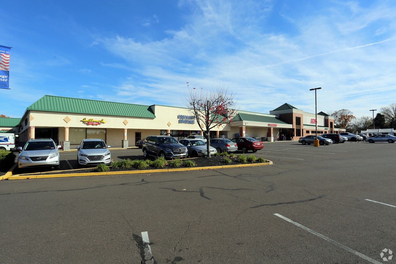
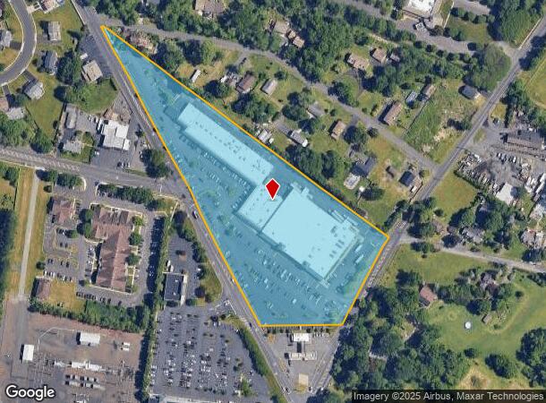
2389 Pasqualone Blvd, Bensalem, PA 19020
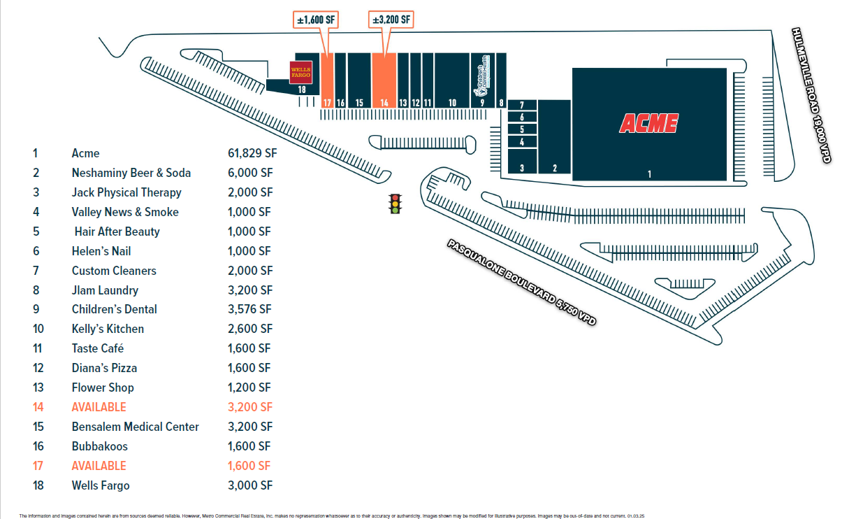
Current Lease Availabilities
NEARBY LISTINGS FOR SALE OR LEASE
Property Detail
2389 Pasqualone Blvd
02-048-006
Fairless Hills
Regionalshoppingcenterormallwithanchorstore
8.068AC E S LR09006 275 FT N SR513
X
Bucks
42017C0443J
Pennsylvania
2024
8.07 AC
2024
Lower Bucks County
100214
Philadelphia
98,863 SF
Philadelphia-Camden-Wilmington, PA-NJ-DE-MD
DEMOGRAPHICS near 2389 Pasqualone Blvd
1 Mile
3 Mile
5 Mile
2024 Total Population
13,709
96,908
241,083
2029 Population
13,723
96,509
238,619
Pop Growth 2024-2029
+ 0.10%
(0.41%)
(1.02%)
Average Age
43
42
42
2024 Total Households
5,109
37,043
90,893
HH Growth 2024-2029
+ 0.14%
(0.49%)
(1.11%)
Median Household Inc
$94,329
$76,960
$84,275
Avg Household Size
2.60
2.50
2.60
2024 Avg HH Vehicles
2.00
2.00
2.00
Median Home Value
$289,895
$305,250
$288,850
Median Year Built
1978
1972
1966
Nearby Places
- Restaurants
- Banks
- Shops
- Fitness
- Groceries
PUBLIC TRANSPORTATION
COMMUTER RAIL
Langhorne (R3 - Southeastern Pennsylvania Transportation Authority Regional Rail (SEPTA Regional Rail))
DRIVE
WALK
Distance
Langhorne (R3 - Southeastern Pennsylvania Transportation Authority Regional Rail (SEPTA Regional Rail))
5 min
2.3 mi
Neshaminy Falls (R3 - Southeastern Pennsylvania Transportation Authority Regional Rail (SEPTA Regional Rail))
DRIVE
WALK
Distance
Neshaminy Falls (R3 - Southeastern Pennsylvania Transportation Authority Regional Rail (SEPTA Regional Rail))
6 min
2.8 mi
AIRPORT
Trenton Mercer
DRIVE
WALK
Distance
Trenton Mercer
22 min
13.7 mi
Philadelphia International
DRIVE
WALK
Distance
Philadelphia International
45 min
29.9 mi
Freight Ports
Port of Philadelphia
DRIVE
WALK
Distance
Port of Philadelphia
25 min
16.2 mi
Nearby Properties
Address
Land Use
TOTAL SIZE
Lot Size
Zoning
Address
Land Use
TOTAL SIZE
Lot Size
Zoning
410.98 AC
R2
Address
Land Use
TOTAL SIZE
Lot Size
Zoning
300,700 SF
30.41 AC
I1
Address
Land Use
TOTAL SIZE
Lot Size
Zoning
207,500 SF
16.18 AC
I1
Address
Land Use
TOTAL SIZE
Lot Size
Zoning
241,392 SF
24.15 AC
I1
Address
Land Use
TOTAL SIZE
Lot Size
Zoning
237,032 SF
15.96 AC
HC
Address
Land Use
TOTAL SIZE
Lot Size
Zoning
154,048 SF
15.74 AC
I1
Address
Land Use
TOTAL SIZE
Lot Size
Zoning
80,000 SF
7.07 AC
I1
Address
Land Use
TOTAL SIZE
Lot Size
Zoning
81,696 SF
14.61 AC
AO
Address
Land Use
TOTAL SIZE
Lot Size
Zoning
32,912 SF
42.06 AC
AO
Address
Land Use
TOTAL SIZE
Lot Size
Zoning
11,280 SF
26.16 AC
R3
Address
Land Use
TOTAL SIZE
Lot Size
Zoning
34,920 SF
38 AC
CD
Address
Land Use
TOTAL SIZE
Lot Size
Zoning
759,617 SF
23.82 AC
HC
Address
Land Use
TOTAL SIZE
Lot Size
Zoning
150,000 SF
21.46 AC
R3
Address
Land Use
TOTAL SIZE
Lot Size
Zoning
10,025 SF
19.10 AC
CD
Address
Land Use
TOTAL SIZE
Lot Size
Zoning
19.95 AC
CD
Address
Land Use
TOTAL SIZE
Lot Size
Zoning
202,400 SF
20.98 AC
C
Address
Land Use
TOTAL SIZE
Lot Size
Zoning
179,920 SF
23.92 AC
CS
Address
Land Use
TOTAL SIZE
Lot Size
Zoning
242,550 SF
24.32 AC
PI
Address
Land Use
TOTAL SIZE
Lot Size
Zoning
10,100 SF
18.52 AC
CD
Address
Land Use
TOTAL SIZE
Lot Size
Zoning
25,000 SF
18.52 AC
CD
Address
Land Use
TOTAL SIZE
Lot Size
Zoning
72,540 SF
14.02 AC
CD
Address
Land Use
TOTAL SIZE
Lot Size
Zoning
10,779 SF
19.07 AC
CD
Address
Land Use
TOTAL SIZE
Lot Size
Zoning
242,550 SF
24.18 AC
PI
Address
Land Use
TOTAL SIZE
Lot Size
Zoning
171,918 SF
17.70 AC
AO
Address
Land Use
TOTAL SIZE
Lot Size
Zoning
206,720 SF
0.97 AC
C
Address
Land Use
TOTAL SIZE
Lot Size
Zoning
281,600 SF
26.57 AC
PI
Address
Land Use
TOTAL SIZE
Lot Size
Zoning
199,758 SF
22.16 AC
HC
Address
Land Use
TOTAL SIZE
Lot Size
Zoning
34,184 SF
14.54 AC
CD
Address
Land Use
TOTAL SIZE
Lot Size
Zoning
19.78 AC
CD
Address
Land Use
TOTAL SIZE
Lot Size
Zoning
181,701 SF
15 AC
C
The World's #1 Commercial Real Estate Marketplace
Connect with us
© 2025 CoStar Group
The information above has been obtained from sources believed reliable. While we do not doubt its accuracy we have not verified it and make no guarantee, warranty or representation about it. It is your responsibility to independently confirm its accuracy and completeness. Any projections, opinions, assumptions, or estimates used are for example only and do not represent the current or future performance of the property. The value of this transaction to you depends on tax and other factors which should be evaluated by your tax, financial, and legal advisors. You and your advisors should conduct a careful, independent investigation of the property to determine to your satisfaction the suitability of the property for your needs.