Property Record
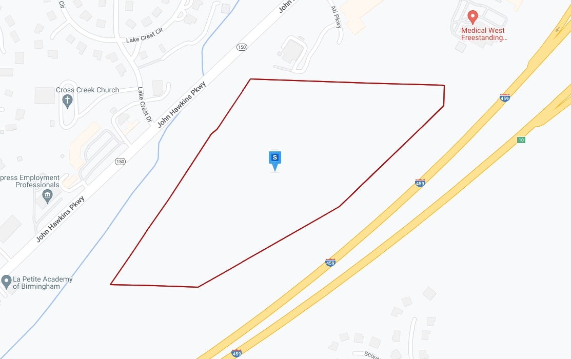
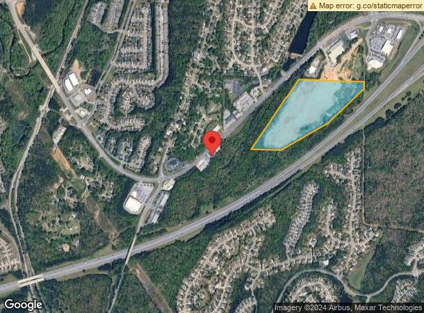
2328 John Hawkins Pkwy, Hoover, AL 35244
NEARBY LISTINGS FOR SALE OR LEASE
Property Detail
2328 John Hawkins Pkwy
Birmingham-Hoover, AL
Final Plat Baronwood Commercia
39-00-28-3-000-001.000
LOT 2 OF FINAL PLAT BARONWOOD COMMERCIAL SUBDIVISION ALL IN TWN 19S RNG 3W SEC 28
Vacantlandnec
Jefferson
X
Alabama
01073C0701H
2
2023
30 AC
2024
Hoover
014414
Birmingham
DEMOGRAPHICS near 2328 John Hawkins Pkwy
1 Mile
3 Mile
5 Mile
2024 Total Population
4,011
33,637
92,975
2029 Population
3,858
33,407
93,992
Pop Growth 2024-2029
(3.81%)
(0.68%)
+ 1.09%
Average Age
40
41
39
2024 Total Households
1,444
12,539
36,520
HH Growth 2024-2029
(3.88%)
(0.72%)
+ 0.88%
Median Household Inc
$109,492
$112,458
$89,300
Avg Household Size
2.80
2.60
2.50
2024 Avg HH Vehicles
2.00
2.00
2.00
Median Home Value
$367,646
$360,358
$303,569
Median Year Built
1999
1996
1992
Nearby Places
- Restaurants
- Banks
- Shops
- Fitness
- Groceries
PUBLIC TRANSPORTATION
AIRPORT
Birmingham-Shuttlesworth International
DRIVE
WALK
Distance
Birmingham-Shuttlesworth International
30 min
20.4 mi
Freight Ports
Port of Mobile
DRIVE
WALK
Distance
Port of Mobile
274 min
251.2 mi
SALE & LEASE HISTORY
LISTING DATE
SALE/LEASE

Sep 24, 2016
For Sale
Nearby Properties
Address
Land Use
TOTAL SIZE
Lot Size
Zoning
Address
Land Use
TOTAL SIZE
Lot Size
Zoning
582,638 SF
43.76 AC
PUDP
Address
Land Use
TOTAL SIZE
Lot Size
Zoning
237,921 SF
6.35 AC
PUDP
Address
Land Use
TOTAL SIZE
Lot Size
Zoning
284,436 SF
40.98 AC
PUDP
Address
Land Use
TOTAL SIZE
Lot Size
Zoning
165,474 SF
90 AC
PR2
Address
Land Use
TOTAL SIZE
Lot Size
Zoning
200,679 SF
20 AC
PR2
Address
Land Use
TOTAL SIZE
Lot Size
Zoning
224,746 SF
46 AC
C2
Address
Land Use
TOTAL SIZE
Lot Size
Zoning
231,385 SF
50.40 AC
R6
Address
Land Use
TOTAL SIZE
Lot Size
Zoning
172,648 SF
39.45 AC
Address
Land Use
TOTAL SIZE
Lot Size
Zoning
185,856 SF
6.70 AC
PC
Address
Land Use
TOTAL SIZE
Lot Size
Zoning
105,299 SF
25.50 AC
T3
Address
Land Use
TOTAL SIZE
Lot Size
Zoning
141,296 SF
14.51 AC
C2
Address
Land Use
TOTAL SIZE
Lot Size
Zoning
83,700 SF
60 AC
PC
Address
Land Use
TOTAL SIZE
Lot Size
Zoning
94,329 SF
15.60 AC
C1
Address
Land Use
TOTAL SIZE
Lot Size
Zoning
35,503 SF
2.92 AC
C2
Address
Land Use
TOTAL SIZE
Lot Size
Zoning
208,000 SF
9.60 AC
SC-1
Address
Land Use
TOTAL SIZE
Lot Size
Zoning
29,302 SF
1.20 AC
A1
Address
Land Use
TOTAL SIZE
Lot Size
Zoning
108,525 SF
10.90 AC
PC
Address
Land Use
TOTAL SIZE
Lot Size
Zoning
64,321 SF
10.46 AC
PC
Address
Land Use
TOTAL SIZE
Lot Size
Zoning
76,255 SF
11.40 AC
C1
Address
Land Use
TOTAL SIZE
Lot Size
Zoning
52,440 SF
10.40 AC
C2
Address
Land Use
TOTAL SIZE
Lot Size
Zoning
3.30 AC
C4
Address
Land Use
TOTAL SIZE
Lot Size
Zoning
46,498 SF
3.70 AC
PUD-
Address
Land Use
TOTAL SIZE
Lot Size
Zoning
92,390 SF
3.30 AC
C2
Address
Land Use
TOTAL SIZE
Lot Size
Zoning
87,429 SF
6.80 AC
PC
Address
Land Use
TOTAL SIZE
Lot Size
Zoning
118,676 SF
4.09 AC
I2
Address
Land Use
TOTAL SIZE
Lot Size
Zoning
23,493 SF
2.85 AC
C1
Address
Land Use
TOTAL SIZE
Lot Size
Zoning
33,964 SF
5.80 AC
C1
Address
Land Use
TOTAL SIZE
Lot Size
Zoning
26,543 SF
1.90 AC
C4
Address
Land Use
TOTAL SIZE
Lot Size
Zoning
41,931 SF
14.50 AC
PC
Address
Land Use
TOTAL SIZE
Lot Size
Zoning
130,568 SF
8.52 AC
SC-1
The World's #1 Commercial Real Estate Marketplace
Connect with us
© 2025 CoStar Group
The information above has been obtained from sources believed reliable. While we do not doubt its accuracy we have not verified it and make no guarantee, warranty or representation about it. It is your responsibility to independently confirm its accuracy and completeness. Any projections, opinions, assumptions, or estimates used are for example only and do not represent the current or future performance of the property. The value of this transaction to you depends on tax and other factors which should be evaluated by your tax, financial, and legal advisors. You and your advisors should conduct a careful, independent investigation of the property to determine to your satisfaction the suitability of the property for your needs.