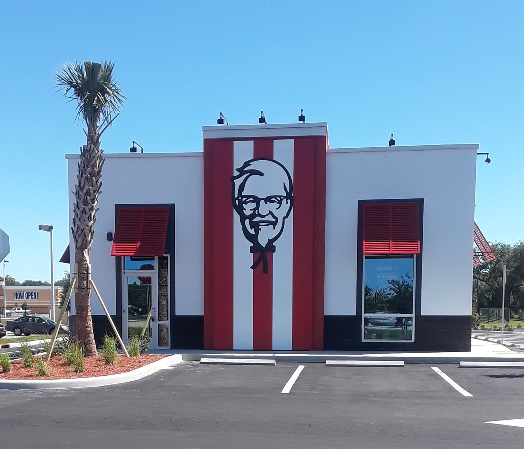
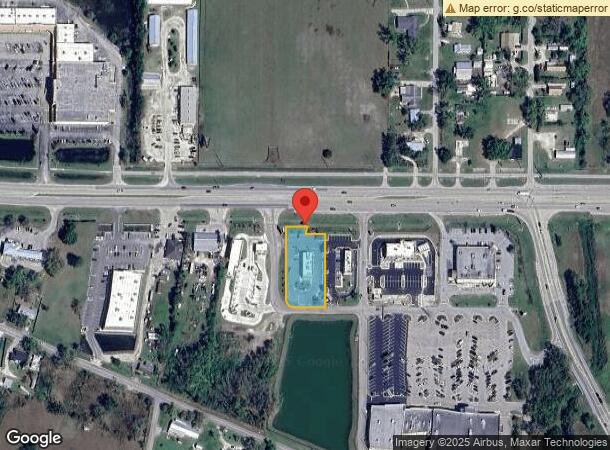
Property Record
2333 Se Highway 70, Arcadia, FL 34266
NEARBY LISTINGS FOR SALE OR LEASE
Property Detail
2333 Se Highway 70
05-38-25-0256-0000-00B0
Arcadia 70/31 Sub
Restaurantbuilding
ARCADIA 70/31 SUBDIVISION TRACT B INST:201814007237 INST:202114000076
X
DeSoto
12027C0179C
Florida
2023
0.83 AC
2023
Florida Central South Area
010102
Other Market Areas
2,916 SF
Arcadia, FL
DEMOGRAPHICS near 2333 Se Highway 70
1 Mile
3 Mile
5 Mile
2024 Total Population
4,862
19,508
23,572
2029 Population
5,287
21,535
25,948
Pop Growth 2024-2029
+ 8.74%
+ 10.39%
+ 10.08%
Average Age
42
39
40
2024 Total Households
1,858
6,690
8,043
HH Growth 2024-2029
+ 9.31%
+ 11.35%
+ 11.08%
Median Household Inc
$31,184
$33,569
$34,917
Avg Household Size
2.60
2.70
2.70
2024 Avg HH Vehicles
1.00
2.00
2.00
Median Home Value
$81,936
$113,868
$115,268
Median Year Built
1984
1982
1986
Nearby Places
- Restaurants
- Banks
- Shops
- Fitness
- Groceries
PUBLIC TRANSPORTATION
AIRPORT
Punta Gorda
DRIVE
WALK
Distance
Punta Gorda
41 min
27.2 mi
Freight Ports
Port Manatee
DRIVE
WALK
Distance
Port Manatee
82 min
59.7 mi
SALE & LEASE HISTORY
LISTING DATE
SALE/LEASE

Sep 10, 2019
For Sale
Nearby Properties
Address
Land Use
TOTAL SIZE
Lot Size
Zoning
Address
Land Use
TOTAL SIZE
Lot Size
Zoning
173.33 AC
P/I
Address
Land Use
TOTAL SIZE
Lot Size
Zoning
106,179 SF
12.48 AC
RPB
Address
Land Use
TOTAL SIZE
Lot Size
Zoning
182,809 SF
60 AC
A-5
Address
Land Use
TOTAL SIZE
Lot Size
Zoning
67,387 SF
46.10 AC
PUD
Address
Land Use
TOTAL SIZE
Lot Size
Zoning
128,748 SF
21.47 AC
CG
Address
Land Use
TOTAL SIZE
Lot Size
Zoning
106,061 SF
15 AC
P/I
Address
Land Use
TOTAL SIZE
Lot Size
Zoning
57,048 SF
20.25 AC
PUD
Address
Land Use
TOTAL SIZE
Lot Size
Zoning
7,911 SF
30 AC
TTRVC
Address
Land Use
TOTAL SIZE
Lot Size
Zoning
67,970 SF
8.24 AC
CG
Address
Land Use
TOTAL SIZE
Lot Size
Zoning
121,889 SF
9 AC
B-3
Address
Land Use
TOTAL SIZE
Lot Size
Zoning
67,407 SF
4.82 AC
R-1B
Address
Land Use
TOTAL SIZE
Lot Size
Zoning
25,798 SF
5 AC
B-1A
Address
Land Use
TOTAL SIZE
Lot Size
Zoning
80,103 SF
11 AC
R-1B
Address
Land Use
TOTAL SIZE
Lot Size
Zoning
76,468 SF
40 AC
P/I
Address
Land Use
TOTAL SIZE
Lot Size
Zoning
39,416 SF
2.29 AC
CG
Address
Land Use
TOTAL SIZE
Lot Size
Zoning
32,546 SF
45.40 AC
P/I
Address
Land Use
TOTAL SIZE
Lot Size
Zoning
53,740 SF
2.29 AC
R-1B
Address
Land Use
TOTAL SIZE
Lot Size
Zoning
23,512 SF
120 AC
MHP
Address
Land Use
TOTAL SIZE
Lot Size
Zoning
46,636 SF
1.30 AC
B-2
Address
Land Use
TOTAL SIZE
Lot Size
Zoning
7,101 SF
30.89 AC
MHP
Address
Land Use
TOTAL SIZE
Lot Size
Zoning
48,488 SF
3.24 AC
B-2
Address
Land Use
TOTAL SIZE
Lot Size
Zoning
97,755 SF
9.20 AC
PUD
Address
Land Use
TOTAL SIZE
Lot Size
Zoning
54,644 SF
11.82 AC
PUD
Address
Land Use
TOTAL SIZE
Lot Size
Zoning
640 AC
A-10
Address
Land Use
TOTAL SIZE
Lot Size
Zoning
640 AC
A-10
Address
Land Use
TOTAL SIZE
Lot Size
Zoning
640 AC
A-10
Address
Land Use
TOTAL SIZE
Lot Size
Zoning
640 AC
A-10
Address
Land Use
TOTAL SIZE
Lot Size
Zoning
640 AC
A-10
Address
Land Use
TOTAL SIZE
Lot Size
Zoning
640 AC
A-10
Address
Land Use
TOTAL SIZE
Lot Size
Zoning
640 AC
A-10
The World's #1 Commercial Real Estate Marketplace
Connect with us
© 2025 CoStar Group
The information above has been obtained from sources believed reliable. While we do not doubt its accuracy we have not verified it and make no guarantee, warranty or representation about it. It is your responsibility to independently confirm its accuracy and completeness. Any projections, opinions, assumptions, or estimates used are for example only and do not represent the current or future performance of the property. The value of this transaction to you depends on tax and other factors which should be evaluated by your tax, financial, and legal advisors. You and your advisors should conduct a careful, independent investigation of the property to determine to your satisfaction the suitability of the property for your needs.