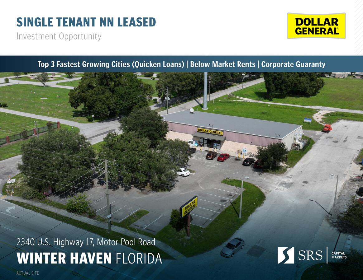
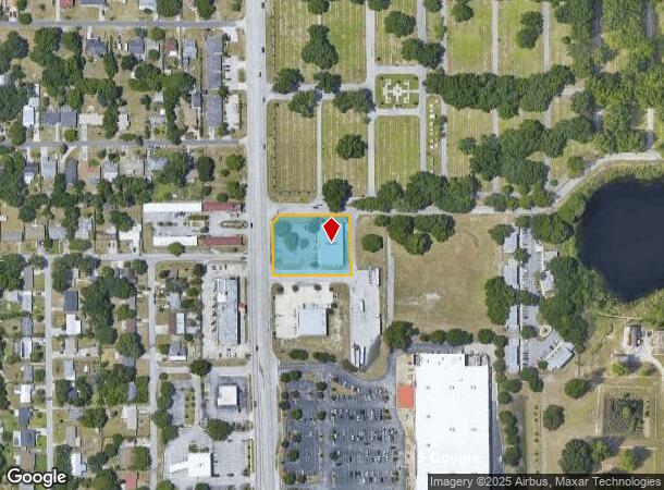
Property Record
2340 8Th St Nw, Winter Haven, FL 33881


This Property Is For Sale
NEARBY LISTINGS FOR SALE OR LEASE
Property Detail
2340 8Th St Nw
26-28-17-000000-023060
Lakeside Memorial Pk 2Nd Repla
Storebuilding
COMM NW COR NW1/4 OF SE1/4 N 87 DEG 20 MIN E-ALONG N-LINE 40.5 FT TO ELY R/W US 17 S 03 DEG 14 MIN E 25 FT FOR POB RUN N 87 DEG 20 MIN E 248 FT S 03 DEG 08 MIN 18 SEC E 207.90 FT S 87 DEG 20 MIN W 248 FT N 03 DEG 48 MIN 56 SEC W 207.90 FT TO POB LESS
X
Polk
12105C0365G
Florida
2023
1.07 AC
2023
Polk County
013602
Tampa/St Petersburg
9,100 SF
Lakeland-Winter Haven, FL
DEMOGRAPHICS near 2340 8Th St Nw
1 Mile
3 Mile
5 Mile
2024 Total Population
6,307
54,179
111,787
2029 Population
7,645
65,267
134,848
Pop Growth 2024-2029
+ 21.21%
+ 20.47%
+ 20.63%
Average Age
43
40
41
2024 Total Households
2,675
21,469
43,603
HH Growth 2024-2029
+ 21.08%
+ 20.42%
+ 20.56%
Median Household Inc
$43,400
$45,423
$53,246
Avg Household Size
2.20
2.40
2.50
2024 Avg HH Vehicles
1.00
2.00
2.00
Median Home Value
$248,963
$174,095
$187,773
Median Year Built
1980
1976
1982
Nearby Places
- Restaurants
- Banks
- Shops
- Fitness
- Groceries
PUBLIC TRANSPORTATION
COMMUTER RAIL
Winter Haven (Silver Meteor - Amtrak, Silver Star - Amtrak)
DRIVE
WALK
Distance
Winter Haven (Silver Meteor - Amtrak, Silver Star - Amtrak)
7 min
3.2 mi
Freight Ports
Port of Tampa Bay
DRIVE
WALK
Distance
Port of Tampa Bay
69 min
48.3 mi
Nearby Properties
Address
Land Use
TOTAL SIZE
Lot Size
Zoning
Address
Land Use
TOTAL SIZE
Lot Size
Zoning
728,846 SF
28.07 AC
Address
Land Use
TOTAL SIZE
Lot Size
Zoning
250,170 SF
24.21 AC
Address
Land Use
TOTAL SIZE
Lot Size
Zoning
282,400 SF
19.59 AC
XX
Address
Land Use
TOTAL SIZE
Lot Size
Zoning
504,548 SF
26.82 AC
BR
Address
Land Use
TOTAL SIZE
Lot Size
Zoning
386,137 SF
39.91 AC
Address
Land Use
TOTAL SIZE
Lot Size
Zoning
267,076 SF
31.67 AC
Address
Land Use
TOTAL SIZE
Lot Size
Zoning
85,378 SF
4.20 AC
BR
Address
Land Use
TOTAL SIZE
Lot Size
Zoning
185,895 SF
16.16 AC
BR
Address
Land Use
TOTAL SIZE
Lot Size
Zoning
148,390 SF
10.42 AC
R1
Address
Land Use
TOTAL SIZE
Lot Size
Zoning
200,200 SF
10.29 AC
Address
Land Use
TOTAL SIZE
Lot Size
Zoning
216,846 SF
24.54 AC
Address
Land Use
TOTAL SIZE
Lot Size
Zoning
503,625 SF
20.61 AC
Address
Land Use
TOTAL SIZE
Lot Size
Zoning
277,680 SF
43.76 AC
R1C
Address
Land Use
TOTAL SIZE
Lot Size
Zoning
102,307 SF
1.79 AC
RP
Address
Land Use
TOTAL SIZE
Lot Size
Zoning
77,388 SF
5.37 AC
BT
Address
Land Use
TOTAL SIZE
Lot Size
Zoning
90,230 SF
8.49 AC
Address
Land Use
TOTAL SIZE
Lot Size
Zoning
199,355 SF
15.71 AC
C4
Address
Land Use
TOTAL SIZE
Lot Size
Zoning
188,403 SF
27.79 AC
BT
Address
Land Use
TOTAL SIZE
Lot Size
Zoning
259,700 SF
51.96 AC
Address
Land Use
TOTAL SIZE
Lot Size
Zoning
135,885 SF
10.12 AC
Address
Land Use
TOTAL SIZE
Lot Size
Zoning
122,752 SF
1.68 AC
Address
Land Use
TOTAL SIZE
Lot Size
Zoning
277,729 SF
423.34 AC
Address
Land Use
TOTAL SIZE
Lot Size
Zoning
173,328 SF
37.45 AC
C3
Address
Land Use
TOTAL SIZE
Lot Size
Zoning
97,912 SF
7.76 AC
ILS
Address
Land Use
TOTAL SIZE
Lot Size
Zoning
90,200 SF
1.93 AC
RP
Address
Land Use
TOTAL SIZE
Lot Size
Zoning
76,664 SF
18.64 AC
RP
Address
Land Use
TOTAL SIZE
Lot Size
Zoning
106,524 SF
11.32 AC
Address
Land Use
TOTAL SIZE
Lot Size
Zoning
172,254 SF
1.81 AC
BR
Address
Land Use
TOTAL SIZE
Lot Size
Zoning
63,072 SF
7.02 AC
RP
Address
Land Use
TOTAL SIZE
Lot Size
Zoning
77,824 SF
12.78 AC
The World's #1 Commercial Real Estate Marketplace
Connect with us
© 2025 CoStar Group
The information above has been obtained from sources believed reliable. While we do not doubt its accuracy we have not verified it and make no guarantee, warranty or representation about it. It is your responsibility to independently confirm its accuracy and completeness. Any projections, opinions, assumptions, or estimates used are for example only and do not represent the current or future performance of the property. The value of this transaction to you depends on tax and other factors which should be evaluated by your tax, financial, and legal advisors. You and your advisors should conduct a careful, independent investigation of the property to determine to your satisfaction the suitability of the property for your needs.