Property Record
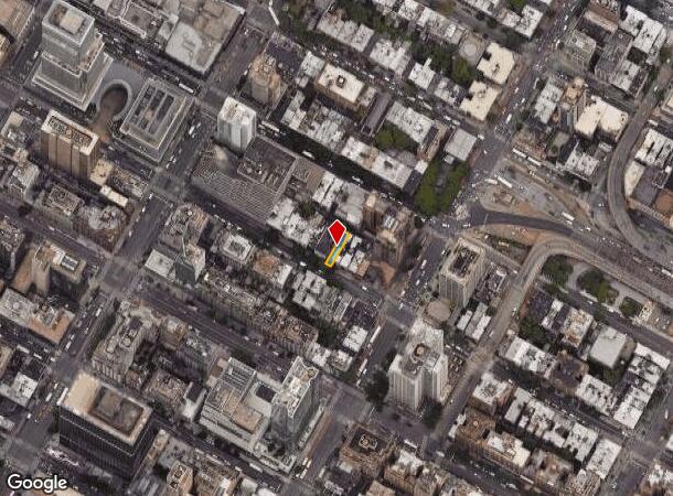
235 E 58Th St, New York, NY 10022
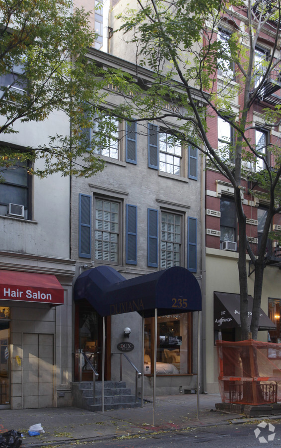

This Property Is For Sale
Current Lease Availabilities
NEARBY LISTINGS FOR SALE OR LEASE
Property Detail
235 E 58Th St
1332-0017
Manhattan
Storebuilding
New York
X
17
3604970089F
0.04 AC
2024
Plaza District
2024
New York City
010803
New York-Jersey City-White Plains, NY-NJ
4,005 SF
DEMOGRAPHICS near 235 E 58Th St
1 Mile
3 Mile
5 Mile
2024 Total Population
163,675
1,319,602
2,923,792
2029 Population
152,242
1,231,186
2,748,511
Pop Growth 2024-2029
(6.99%)
(6.70%)
(5.99%)
Average Age
44
41
40
2024 Total Households
91,878
663,866
1,292,902
HH Growth 2024-2029
(7.00%)
(6.92%)
(6.32%)
Median Household Inc
$130,960
$102,450
$86,269
Avg Household Size
1.70
1.90
2.10
2024 Avg HH Vehicles
.00
.00
.00
Median Home Value
$1,008,813
$965,239
$847,220
Median Year Built
1961
1956
1956
Nearby Places
- Restaurants
- Banks
- Shops
- Fitness
- Groceries
PUBLIC TRANSPORTATION
TRANSIT/SUBWAY
59 Street (4,5,6 Line) (4 - New York MTA Subway (The Subway), 5 - New York MTA Subway (The Subway), 6 - New York MTA Subway (The Subway))
DRIVE
WALK
Distance
59 Street (4,5,6 Line) (4 - New York MTA Subway (The Subway), 5 - New York MTA Subway (The Subway), 6 - New York MTA Subway (The Subway))
1 min
4 min
0.2 mi
Lexington Avenue-59 Street (N - New York MTA Subway (The Subway), Q - New York MTA Subway (The Subway), R - New York MTA Subway (The Subway))
DRIVE
WALK
Distance
Lexington Avenue-59 Street (N - New York MTA Subway (The Subway), Q - New York MTA Subway (The Subway), R - New York MTA Subway (The Subway))
1 min
4 min
0.2 mi
Lexington Av/53 St (8 Avenue Local - MTA New York City Transit, Queens Blvd Local/6 Av Local - MTA New York City Transit)
DRIVE
WALK
Distance
Lexington Av/53 St (8 Avenue Local - MTA New York City Transit, Queens Blvd Local/6 Av Local - MTA New York City Transit)
1 min
6 min
0.3 mi
Lexington Avenue-63 Street (F - New York MTA Subway (The Subway))
DRIVE
WALK
Distance
Lexington Avenue-63 Street (F - New York MTA Subway (The Subway))
2 min
8 min
0.4 mi
Lexington Avenue-53 Street (E - New York MTA Subway (The Subway), M - New York MTA Subway (The Subway))
DRIVE
WALK
Distance
Lexington Avenue-53 Street (E - New York MTA Subway (The Subway), M - New York MTA Subway (The Subway))
1 min
8 min
0.4 mi
COMMUTER RAIL
Grand Central (Babylon Branch - Long Island Rail Road, Far Rockaway Branch - Long Island Rail Road, Hempstead Branch - Long Island Rail Road, Port Jefferson Branch - Long Island Rail Road, Port Washington Branch - Long Island Rail Road)
DRIVE
WALK
Distance
Grand Central (Babylon Branch - Long Island Rail Road, Far Rockaway Branch - Long Island Rail Road, Hempstead Branch - Long Island Rail Road, Port Jefferson Branch - Long Island Rail Road, Port Washington Branch - Long Island Rail Road)
2 min
16 min
0.8 mi
Grand Central Terminal (Harlem Line - Metro-North Commuter Railroad Company (Metro-North), Hudson Line - Metro-North Commuter Railroad Company (Metro-North), New Haven Line - Metro-North Commuter Railroad Company (Metro-North))
DRIVE
WALK
Distance
Grand Central Terminal (Harlem Line - Metro-North Commuter Railroad Company (Metro-North), Hudson Line - Metro-North Commuter Railroad Company (Metro-North), New Haven Line - Metro-North Commuter Railroad Company (Metro-North))
3 min
20 min
1.0 mi
AIRPORT
Laguardia
DRIVE
WALK
Distance
Laguardia
13 min
6.5 mi
Newark Liberty International
DRIVE
WALK
Distance
Newark Liberty International
23 min
15.7 mi
John F Kennedy International
DRIVE
WALK
Distance
John F Kennedy International
26 min
16.4 mi
Freight Ports
NY - Red Hook Container Terminal
DRIVE
WALK
Distance
NY - Red Hook Container Terminal
19 min
9.1 mi
Nearby Properties
Address
Land Use
TOTAL SIZE
Lot Size
Zoning
Address
Land Use
TOTAL SIZE
Lot Size
Zoning
4,060,596 SF
22.09 AC
M2-3
Address
Land Use
TOTAL SIZE
Lot Size
Zoning
1,783,434 SF
1.94 AC
C5-3
Address
Land Use
TOTAL SIZE
Lot Size
Zoning
2,245,112 SF
2.02 AC
C6-6
Address
Land Use
TOTAL SIZE
Lot Size
Zoning
2,521,850 SF
1.59 AC
C6-4
Address
Land Use
TOTAL SIZE
Lot Size
Zoning
2,221,336 SF
1.55 AC
C6-4
Address
Land Use
TOTAL SIZE
Lot Size
Zoning
2,161,994 SF
3.79 AC
M1-5
Address
Land Use
TOTAL SIZE
Lot Size
Zoning
2,636,182 SF
2.35 AC
C65.5
Address
Land Use
TOTAL SIZE
Lot Size
Zoning
1,678,135 SF
1.01 AC
C5-3
Address
Land Use
TOTAL SIZE
Lot Size
Zoning
2,734,038 SF
4.24 AC
C52.5
Address
Land Use
TOTAL SIZE
Lot Size
Zoning
1,897,491 SF
2.06 AC
C52.5
Address
Land Use
TOTAL SIZE
Lot Size
Zoning
1,638,259 SF
1.42 AC
C52.5
Address
Land Use
TOTAL SIZE
Lot Size
Zoning
1,233,684 SF
16.94 AC
PARK
Address
Land Use
TOTAL SIZE
Lot Size
Zoning
2,360,627 SF
2.08 AC
C6-7
Address
Land Use
TOTAL SIZE
Lot Size
Zoning
1,586,876 SF
1.87 AC
C5-3
Address
Land Use
TOTAL SIZE
Lot Size
Zoning
1,048,620 SF
5.67 AC
C6-4
Address
Land Use
TOTAL SIZE
Lot Size
Zoning
1,962,900 SF
1.89 AC
C66.5
Address
Land Use
TOTAL SIZE
Lot Size
Zoning
1,842,991 SF
2.08 AC
C66.5
Address
Land Use
TOTAL SIZE
Lot Size
Zoning
1,178,640 SF
0.92 AC
C6-4
Address
Land Use
TOTAL SIZE
Lot Size
Zoning
2,535,958 SF
2.94 AC
C6-4
Address
Land Use
TOTAL SIZE
Lot Size
Zoning
1,751,641 SF
1.84 AC
C6-4
Address
Land Use
TOTAL SIZE
Lot Size
Zoning
1,642,675 SF
1.05 AC
C6-7
Address
Land Use
TOTAL SIZE
Lot Size
Zoning
2,215,000 SF
6.43 AC
R9
Address
Land Use
TOTAL SIZE
Lot Size
Zoning
1,805,894 SF
1.42 AC
C6-4
Address
Land Use
TOTAL SIZE
Lot Size
Zoning
264,420 SF
7.26 AC
C4-7
Address
Land Use
TOTAL SIZE
Lot Size
Zoning
1,606,528 SF
1.84 AC
C6-6
Address
Land Use
TOTAL SIZE
Lot Size
Zoning
1,649,604 SF
1.51 AC
C67T
Address
Land Use
TOTAL SIZE
Lot Size
Zoning
1,448,897 SF
1.56 AC
C6-6
Address
Land Use
TOTAL SIZE
Lot Size
Zoning
2,400,000 SF
15.14 AC
C5-2
Address
Land Use
TOTAL SIZE
Lot Size
Zoning
1,482,208 SF
1.71 AC
C5-3
Address
Land Use
TOTAL SIZE
Lot Size
Zoning
2,124,441 SF
17.29 AC
R8
The World's #1 Commercial Real Estate Marketplace
Connect with us
© 2025 CoStar Group
The information above has been obtained from sources believed reliable. While we do not doubt its accuracy we have not verified it and make no guarantee, warranty or representation about it. It is your responsibility to independently confirm its accuracy and completeness. Any projections, opinions, assumptions, or estimates used are for example only and do not represent the current or future performance of the property. The value of this transaction to you depends on tax and other factors which should be evaluated by your tax, financial, and legal advisors. You and your advisors should conduct a careful, independent investigation of the property to determine to your satisfaction the suitability of the property for your needs.