Property Record
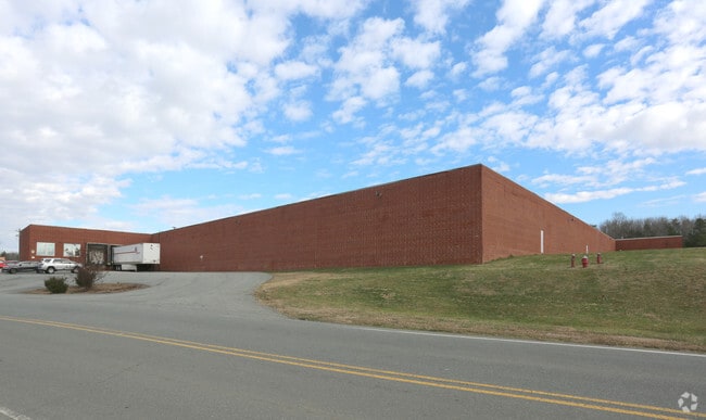
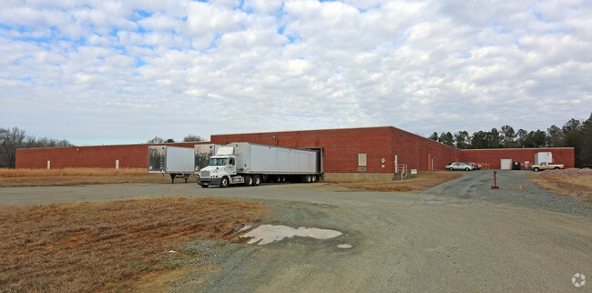
2350 Long Dairy Rd, Graham, NC 27253

Property Detail
2350 Long Dairy Rd
152447
BA HWY 54 9-11-24A
Manufacturinglight
Alamance
B and X Area of moderate flood hazard, usually the area between the limits of the 100-year and 500-year floods.
North Carolina
2025
19.50 AC
2025
SE Alamance County
021204
Greensboro/Winston-Salem
177,340 SF
Burlington, NC
NEARBY LISTINGS FOR SALE OR LEASE
-
-
View all Graham listings for sale on LoopNet.com
DEMOGRAPHICS near 2350 Long Dairy Rd
1 mile
3 mile
5 mile
2025 Total Population
2,948
15,294
52,348
2030 Population
3,168
16,323
55,373
Pop Growth 2025-2030
+ 7.46%
+ 6.73%
+ 5.78%
Average Age
42
42
40
2025 Total Households
1,141
6,231
21,175
HH Growth 2025-2030
+ 7.54%
+ 6.82%
+ 5.94%
Median Household Inc
$86,865
$73,928
$67,528
Avg Household Size
2.50
2.40
2.40
2025 Avg HH Vehicles
2.00
2.00
2.00
Median Home Value
$321,138
$298,125
$278,738
Median Year Built
1994
1993
1992
Nearby Places
Map Layers
Map Styles
 Street
 Aerial
Layers
 Traffic
 Biking
Places
Listings with unknown addresses are not visible on the map
- Restaurants
- Banks
- Shops
- Fitness
- Groceries
PUBLIC TRANSPORTATION
COMMUTER RAIL
Burlington Station (Piedmont - North Carolina by Train (NC Train))
Drive
Walk
Distance
Burlington Station (Piedmont - North Carolina by Train (NC Train))
12 min
6.9 mi
Freight Ports
Virginia Port Authority - Richmond
Drive
Walk
Distance
Virginia Port Authority - Richmond
200 min
173.2 mi
Nearby Properties
Address
Land Use
TOTAL SIZE
Lot Size
Zoning
Address
Land Use
TOTAL SIZE
Lot Size
Zoning
18,778 SF
167.10 AC
R20
Address
Land Use
TOTAL SIZE
Lot Size
Zoning
22,500 SF
100.73 AC
Address
Land Use
TOTAL SIZE
Lot Size
Zoning
919,840 SF
85.58 AC
Address
Land Use
TOTAL SIZE
Lot Size
Zoning
9,728 SF
184.66 AC
M 2
Address
Land Use
TOTAL SIZE
Lot Size
Zoning
159,629 SF
82.81 AC
Address
Land Use
TOTAL SIZE
Lot Size
Zoning
578,100 SF
55.30 AC
Address
Land Use
TOTAL SIZE
Lot Size
Zoning
48,136 SF
14.57 AC
B 2
Address
Land Use
TOTAL SIZE
Lot Size
Zoning
333,775 SF
46.14 AC
Address
Land Use
TOTAL SIZE
Lot Size
Zoning
37,502 SF
17.48 AC
CR
Address
Land Use
TOTAL SIZE
Lot Size
Zoning
27,803 SF
11.53 AC
Address
Land Use
TOTAL SIZE
Lot Size
Zoning
296,940 SF
33.78 AC
Address
Land Use
TOTAL SIZE
Lot Size
Zoning
248,000 SF
21.77 AC
Address
Land Use
TOTAL SIZE
Lot Size
Zoning
750 SF
65.26 AC
M 2
Address
Land Use
TOTAL SIZE
Lot Size
Zoning
10,368 SF
11.35 AC
R MF
Address
Land Use
TOTAL SIZE
Lot Size
Zoning
134,000 SF
23.33 AC
Address
Land Use
TOTAL SIZE
Lot Size
Zoning
156,000 SF
23.21 AC
Address
Land Use
TOTAL SIZE
Lot Size
Zoning
134,230 SF
22.73 AC
M 2
Address
Land Use
TOTAL SIZE
Lot Size
Zoning
296,940 SF
36 AC
Address
Land Use
TOTAL SIZE
Lot Size
Zoning
31,920 SF
4.59 AC
R MF
Address
Land Use
TOTAL SIZE
Lot Size
Zoning
7,192 SF
14.08 AC
RMF
Address
Land Use
TOTAL SIZE
Lot Size
Zoning
36,000 SF
4.43 AC
Address
Land Use
TOTAL SIZE
Lot Size
Zoning
64,442 SF
8.80 AC
B 2
Address
Land Use
TOTAL SIZE
Lot Size
Zoning
139,530 SF
21.73 AC
Address
Land Use
TOTAL SIZE
Lot Size
Zoning
81,675 SF
21.18 AC
I 2
Address
Land Use
TOTAL SIZE
Lot Size
Zoning
20,000 SF
8.48 AC
B 2
Address
Land Use
TOTAL SIZE
Lot Size
Zoning
17,749 SF
20 AC
Address
Land Use
TOTAL SIZE
Lot Size
Zoning
55,526 SF
5.96 AC
I 1
Address
Land Use
TOTAL SIZE
Lot Size
Zoning
3,600 SF
6.80 AC
R 18
Address
Land Use
TOTAL SIZE
Lot Size
Zoning
69,140 SF
4.49 AC
IND 1
The World's #1 Commercial Real Estate Marketplace
Connect with us
© 2026 CoStar Group
The information above has been obtained from sources believed reliable. While we do not doubt its accuracy we have not verified it and make no guarantee, warranty or representation about it. It is your responsibility to independently confirm its accuracy and completeness. Any projections, opinions, assumptions, or estimates used are for example only and do not represent the current or future performance of the property. The value of this transaction to you depends on tax and other factors which should be evaluated by your tax, financial, and legal advisors. You and your advisors should conduct a careful, independent investigation of the property to determine to your satisfaction the suitability of the property for your needs.