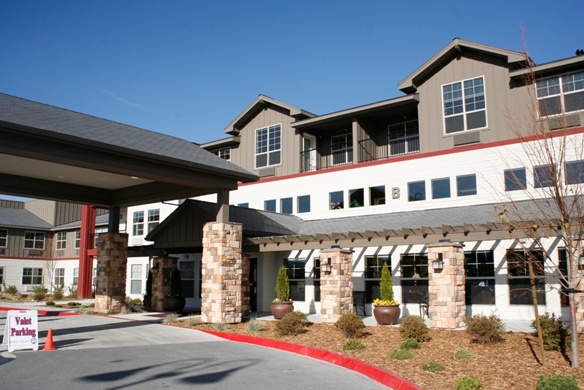
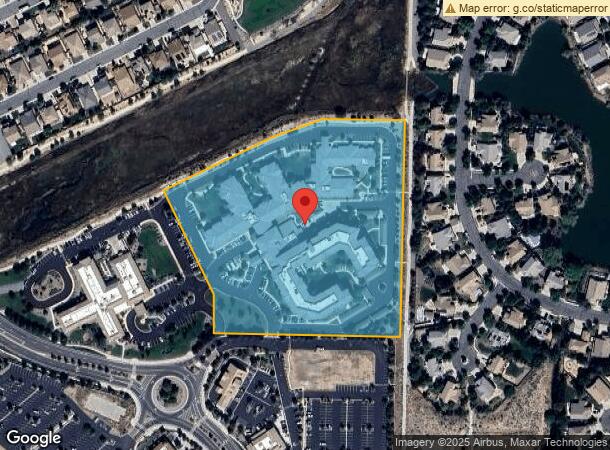
Property Record
2360 Wingfield Hills Rd, Sparks, NV 89436
NEARBY LISTINGS FOR SALE OR LEASE
-
-
View all Sparks listings for sale on LoopNet.com
Property Detail
2360 Wingfield Hills Rd
Reno, NV
_Unspecified
528-010-38
PM 4757 LT 2-1B
Commercialnec
Washoe
X
Nevada
32031C3052G
2
2024
8.66 AC
2024
Sparks
003520
Reno/Sparks
236,695 SF
DEMOGRAPHICS near 2360 Wingfield Hills Rd
1 Mile
3 Mile
5 Mile
2024 Total Population
9,505
48,600
109,211
2029 Population
10,223
51,250
114,960
Pop Growth 2024-2029
+ 7.55%
+ 5.45%
+ 5.26%
Average Age
40
41
40
2024 Total Households
3,584
17,663
38,914
HH Growth 2024-2029
+ 7.56%
+ 5.58%
+ 5.41%
Median Household Inc
$113,191
$106,187
$93,239
Avg Household Size
2.60
2.70
2.80
2024 Avg HH Vehicles
2.00
2.00
2.00
Median Home Value
$513,774
$467,437
$432,438
Median Year Built
2007
2003
1997
Nearby Places
- Restaurants
- Banks
- Shops
- Fitness
- Groceries
PUBLIC TRANSPORTATION
AIRPORT
Reno/Tahoe International
DRIVE
WALK
Distance
Reno/Tahoe International
39 min
15.5 mi
Freight Ports
Port of Stockton
DRIVE
WALK
Distance
Port of Stockton
225 min
189.8 mi
Nearby Properties
Address
Land Use
TOTAL SIZE
Lot Size
Zoning
Address
Land Use
TOTAL SIZE
Lot Size
Zoning
416,482 SF
21.84 AC
PD
Address
Land Use
TOTAL SIZE
Lot Size
Zoning
271,111 SF
31.84 AC
NUD
Address
Land Use
TOTAL SIZE
Lot Size
Zoning
406,338 SF
15.07 AC
NUD
Address
Land Use
TOTAL SIZE
Lot Size
Zoning
308,431 SF
20 AC
PD
Address
Land Use
TOTAL SIZE
Lot Size
Zoning
333,867 SF
14.71 AC
NUD
Address
Land Use
TOTAL SIZE
Lot Size
Zoning
238,764 SF
7 AC
NC
Address
Land Use
TOTAL SIZE
Lot Size
Zoning
230,897 SF
11.52 AC
NUD
Address
Land Use
TOTAL SIZE
Lot Size
Zoning
74,637 SF
6.04 AC
NUD
Address
Land Use
TOTAL SIZE
Lot Size
Zoning
13,874 SF
448.16 AC
PF
Address
Land Use
TOTAL SIZE
Lot Size
Zoning
70,030 SF
36.71 AC
PSP
Address
Land Use
TOTAL SIZE
Lot Size
Zoning
122,223 SF
20 AC
PSP
Address
Land Use
TOTAL SIZE
Lot Size
Zoning
112,215 SF
5.49 AC
NUD
Address
Land Use
TOTAL SIZE
Lot Size
Zoning
209,527 SF
5.28 AC
NC
Address
Land Use
TOTAL SIZE
Lot Size
Zoning
137,236 SF
10.02 AC
PD
Address
Land Use
TOTAL SIZE
Lot Size
Zoning
57,702 SF
5.27 AC
PD
Address
Land Use
TOTAL SIZE
Lot Size
Zoning
81,122 SF
8.44 AC
NUD
Address
Land Use
TOTAL SIZE
Lot Size
Zoning
58,299 SF
6.75 AC
PD
Address
Land Use
TOTAL SIZE
Lot Size
Zoning
44,138 SF
4.09 AC
C2
Address
Land Use
TOTAL SIZE
Lot Size
Zoning
61,048 SF
10.53 AC
NUD
Address
Land Use
TOTAL SIZE
Lot Size
Zoning
61,048 SF
13.10 AC
PSP
Address
Land Use
TOTAL SIZE
Lot Size
Zoning
68,850 SF
7.47 AC
C2
Address
Land Use
TOTAL SIZE
Lot Size
Zoning
40.56 AC
NUD
Address
Land Use
TOTAL SIZE
Lot Size
Zoning
54,237 SF
8 AC
PD
Address
Land Use
TOTAL SIZE
Lot Size
Zoning
102,137 SF
8.46 AC
NC
Address
Land Use
TOTAL SIZE
Lot Size
Zoning
60,382 SF
20.02 AC
PF
Address
Land Use
TOTAL SIZE
Lot Size
Zoning
25.38 AC
NUD
Address
Land Use
TOTAL SIZE
Lot Size
Zoning
55,889 SF
9.87 AC
PSP
Address
Land Use
TOTAL SIZE
Lot Size
Zoning
52,128 SF
6.70 AC
GC
Address
Land Use
TOTAL SIZE
Lot Size
Zoning
102,593 SF
6.66 AC
C2
The World's #1 Commercial Real Estate Marketplace
Connect with us
© 2025 CoStar Group
The information above has been obtained from sources believed reliable. While we do not doubt its accuracy we have not verified it and make no guarantee, warranty or representation about it. It is your responsibility to independently confirm its accuracy and completeness. Any projections, opinions, assumptions, or estimates used are for example only and do not represent the current or future performance of the property. The value of this transaction to you depends on tax and other factors which should be evaluated by your tax, financial, and legal advisors. You and your advisors should conduct a careful, independent investigation of the property to determine to your satisfaction the suitability of the property for your needs.