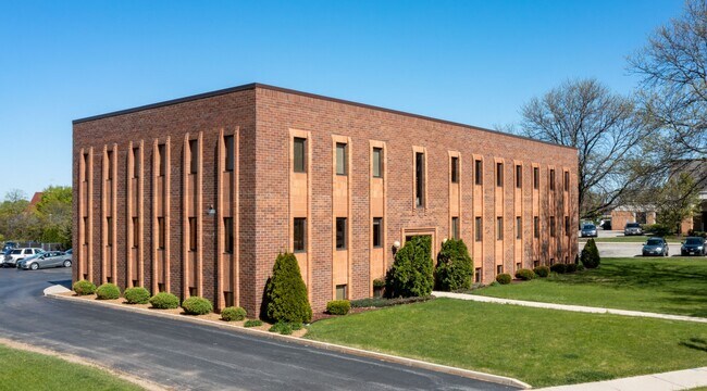
Property Record
2363 S 102Nd St, Milwaukee, WI 53227

NEARBY LISTINGS FOR SALE OR LEASE
Property Detail
2363 S 102Nd St
485-9995-014
COM 1255 FT E OF NW COR & 444.39 FT S OF N LI NW 8-6-21 TH S 110 FT SELY 270.69 FT NELY ALG WLY LI OF S 102 ST 181.57 FT TH W 360.25 FT TO BEG
Commercialnec
Milwaukee
X
Wisconsin
55133C0250G
1 AC
2024
West Allis
2024
Milwaukee/Madison
101100
Milwaukee-Waukesha-West Allis, WI
DEMOGRAPHICS near 2363 S 102Nd St
1 Mile
3 Mile
5 Mile
2024 Total Population
12,672
118,615
288,049
2029 Population
12,391
116,907
284,719
Pop Growth 2024-2029
(2.22%)
(1.44%)
(1.16%)
Average Age
41
41
41
2024 Total Households
6,179
53,022
124,364
HH Growth 2024-2029
(2.23%)
(1.47%)
(1.20%)
Median Household Inc
$58,742
$67,878
$71,103
Avg Household Size
2.00
2.20
2.20
2024 Avg HH Vehicles
1.00
2.00
2.00
Median Home Value
$166,702
$201,717
$235,963
Median Year Built
1960
1959
1957
Nearby Places
Map Layers
Map Styles
 Street
 Aerial
- Restaurants
- Banks
- Shops
- Fitness
- Groceries
PUBLIC TRANSPORTATION
COMMUTER RAIL
DRIVE
WALK
Distance
14 min
8.1 mi
AIRPORT
General Mitchell International
DRIVE
WALK
Distance
General Mitchell International
21 min
11.1 mi
SALE & LEASE HISTORY
LISTING DATE
SALE/LEASE

Sep 25, 2016
For Lease
Jul 31, 2024
For Sale
Jan 27, 2022
For Sale
Feb 28, 2020
For Lease
Nearby Properties
Address
Land Use
TOTAL SIZE
Lot Size
Zoning
Address
Land Use
TOTAL SIZE
Lot Size
Zoning
8.63 AC
C2
Address
Land Use
TOTAL SIZE
Lot Size
Zoning
4.07 AC
Address
Land Use
TOTAL SIZE
Lot Size
Zoning
36.11 AC
Address
Land Use
TOTAL SIZE
Lot Size
Zoning
6.74 AC
Address
Land Use
TOTAL SIZE
Lot Size
Zoning
23.16 AC
Address
Land Use
TOTAL SIZE
Lot Size
Zoning
20.36 AC
Address
Land Use
TOTAL SIZE
Lot Size
Zoning
13.48 AC
Address
Land Use
TOTAL SIZE
Lot Size
Zoning
5.12 AC
Address
Land Use
TOTAL SIZE
Lot Size
Zoning
Address
Land Use
TOTAL SIZE
Lot Size
Zoning
10.22 AC
SP-RP
Address
Land Use
TOTAL SIZE
Lot Size
Zoning
234,132 SF
22.70 AC
RM1
Address
Land Use
TOTAL SIZE
Lot Size
Zoning
Address
Land Use
TOTAL SIZE
Lot Size
Zoning
8.70 AC
Address
Land Use
TOTAL SIZE
Lot Size
Zoning
8,881 SF
7.52 AC
Address
Land Use
TOTAL SIZE
Lot Size
Zoning
13.39 AC
Address
Land Use
TOTAL SIZE
Lot Size
Zoning
18.79 AC
Address
Land Use
TOTAL SIZE
Lot Size
Zoning
16.84 AC
Address
Land Use
TOTAL SIZE
Lot Size
Zoning
Address
Land Use
TOTAL SIZE
Lot Size
Zoning
29,664 SF
1.83 AC
C2
Address
Land Use
TOTAL SIZE
Lot Size
Zoning
Address
Land Use
TOTAL SIZE
Lot Size
Zoning
213,840 SF
13.95 AC
PUDR5
Address
Land Use
TOTAL SIZE
Lot Size
Zoning
16.20 AC
Address
Land Use
TOTAL SIZE
Lot Size
Zoning
Address
Land Use
TOTAL SIZE
Lot Size
Zoning
Address
Land Use
TOTAL SIZE
Lot Size
Zoning
174,510 SF
7.37 AC
PD
Address
Land Use
TOTAL SIZE
Lot Size
Zoning
158,246 SF
11.34 AC
RM1
Address
Land Use
TOTAL SIZE
Lot Size
Zoning
164,825 SF
7.93 AC
PD
Address
Land Use
TOTAL SIZE
Lot Size
Zoning
7.55 AC
SP-INS
Address
Land Use
TOTAL SIZE
Lot Size
Zoning
159,673 SF
6.69 AC
PD
Address
Land Use
TOTAL SIZE
Lot Size
Zoning
5.31 AC
The World's #1 Commercial Real Estate Marketplace
Connect with us
© 2025 CoStar Group
The information above has been obtained from sources believed reliable. While we do not doubt its accuracy we have not verified it and make no guarantee, warranty or representation about it. It is your responsibility to independently confirm its accuracy and completeness. Any projections, opinions, assumptions, or estimates used are for example only and do not represent the current or future performance of the property. The value of this transaction to you depends on tax and other factors which should be evaluated by your tax, financial, and legal advisors. You and your advisors should conduct a careful, independent investigation of the property to determine to your satisfaction the suitability of the property for your needs.