Property Record
23861 Darkhorse Dr, Auburn, CA 95602
This Property Is For Sale
NEARBY LISTINGS FOR SALE OR LEASE
Property Detail
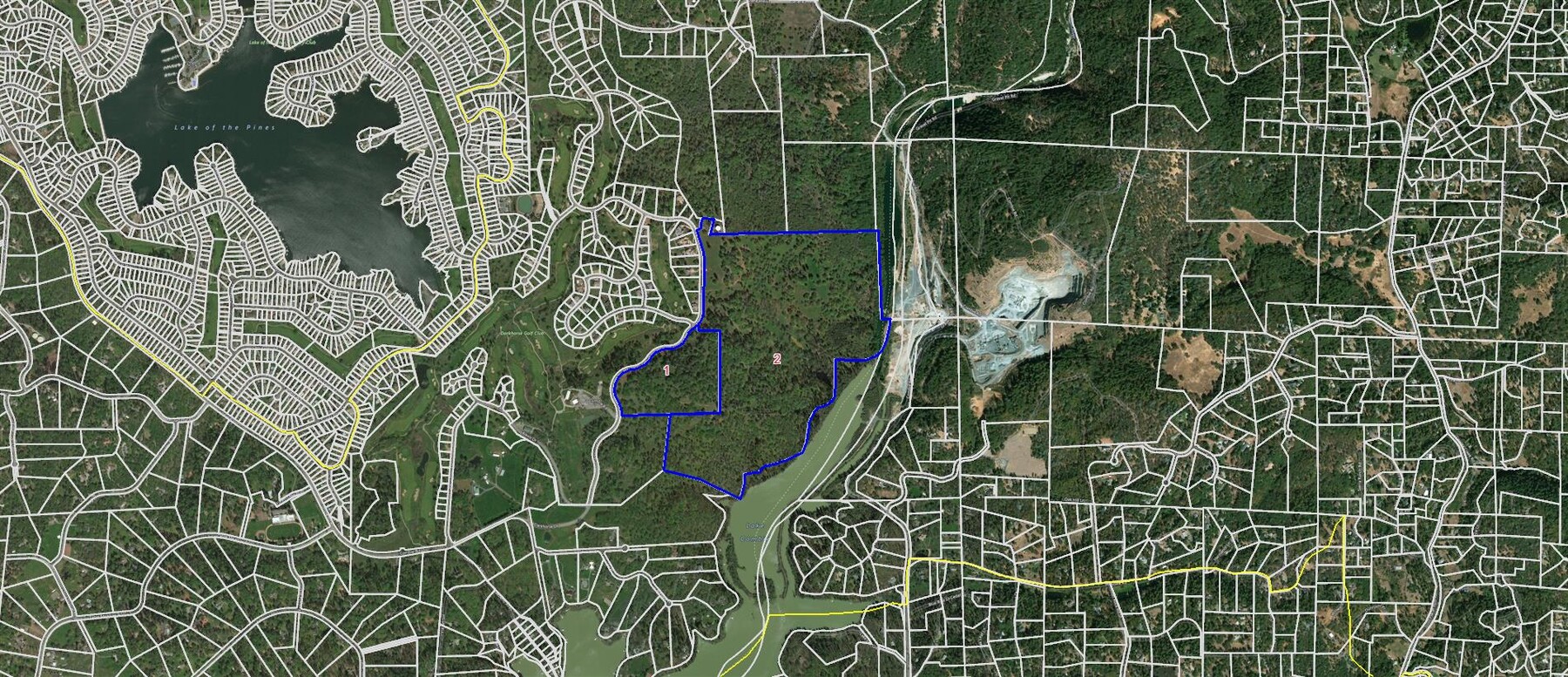
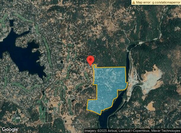
23861 Darkhorse Dr
Truckee-Grass Valley, CA
Darkhorse
011-181-018-000
PCL CC DARKHORSE & PTN 36-14-8
Agriculturalland
Nevada
A
California
06061C0475H
cc
2023
184.37 AC
2024
California North Rural Area
000106
Other Market Areas
DEMOGRAPHICS near 23861 Darkhorse Dr
1 Mile
3 Mile
5 Mile
2024 Total Population
1,396
11,381
21,490
2029 Population
1,446
11,677
22,203
Pop Growth 2024-2029
+ 3.58%
+ 2.60%
+ 3.32%
Average Age
51
48
48
2024 Total Households
562
4,521
8,523
HH Growth 2024-2029
+ 3.56%
+ 2.54%
+ 3.30%
Median Household Inc
$94,999
$102,007
$102,096
Avg Household Size
2.40
2.40
2.50
2024 Avg HH Vehicles
2.00
2.00
3.00
Median Home Value
$578,740
$620,340
$647,102
Median Year Built
1981
1980
1981
Nearby Places
- Restaurants
- Banks
- Shops
- Fitness
- Groceries
Nearby Properties
Address
Land Use
TOTAL SIZE
Lot Size
Zoning
Address
Land Use
TOTAL SIZE
Lot Size
Zoning
5.52 AC
Address
Land Use
TOTAL SIZE
Lot Size
Zoning
25,195 SF
3.20 AC
C2-SC-SP
Address
Land Use
TOTAL SIZE
Lot Size
Zoning
58,478 SF
5.31 AC
C1-SC-SP
Address
Land Use
TOTAL SIZE
Lot Size
Zoning
47,083 SF
11.43 AC
C2SCSP
Address
Land Use
TOTAL SIZE
Lot Size
Zoning
3,351 SF
1.41 AC
C2-SC-SP
Address
Land Use
TOTAL SIZE
Lot Size
Zoning
43,150 SF
5.61 AC
RA-1.5
Address
Land Use
TOTAL SIZE
Lot Size
Zoning
26,537 SF
2.48 AC
C2DC
Address
Land Use
TOTAL SIZE
Lot Size
Zoning
36,632 SF
11.98 AC
RA-5
Address
Land Use
TOTAL SIZE
Lot Size
Zoning
3,600 SF
170.26 AC
RECPDSP
Address
Land Use
TOTAL SIZE
Lot Size
Zoning
14,085 SF
1.58 AC
C2-SC-SP
Address
Land Use
TOTAL SIZE
Lot Size
Zoning
2,980 SF
1.34 AC
C2-SC-SP
Address
Land Use
TOTAL SIZE
Lot Size
Zoning
31,600 SF
1.93 AC
M1-SC-SP
Address
Land Use
TOTAL SIZE
Lot Size
Zoning
30,520 SF
6.16 AC
BP-SC-SP
Address
Land Use
TOTAL SIZE
Lot Size
Zoning
3,192 SF
3.88 AC
C2-SC-SP
Address
Land Use
TOTAL SIZE
Lot Size
Zoning
4,154 SF
1.80 AC
C2DC
Address
Land Use
TOTAL SIZE
Lot Size
Zoning
8,000 SF
1.65 AC
M1-SC-SP
Address
Land Use
TOTAL SIZE
Lot Size
Zoning
12,695 SF
1.15 AC
BP-SC
Address
Land Use
TOTAL SIZE
Lot Size
Zoning
3,584 SF
5.07 AC
RA-1.5
Address
Land Use
TOTAL SIZE
Lot Size
Zoning
6,220 SF
0.82 AC
C2DC
Address
Land Use
TOTAL SIZE
Lot Size
Zoning
4,800 SF
0.51 AC
C2DC
Address
Land Use
TOTAL SIZE
Lot Size
Zoning
14,562 SF
3.75 AC
C1-SC-SP
Address
Land Use
TOTAL SIZE
Lot Size
Zoning
20,454 SF
1.90 AC
RSAGB40
Address
Land Use
TOTAL SIZE
Lot Size
Zoning
2,500 SF
0.80 AC
C2-SC-SP
Address
Land Use
TOTAL SIZE
Lot Size
Zoning
10,591 SF
0.68 AC
C2DC
Address
Land Use
TOTAL SIZE
Lot Size
Zoning
2,889 SF
1 AC
OPB40DC
Address
Land Use
TOTAL SIZE
Lot Size
Zoning
12,060 SF
1.30 AC
C3DC
Address
Land Use
TOTAL SIZE
Lot Size
Zoning
1,632 SF
1.30 AC
OPDC
Address
Land Use
TOTAL SIZE
Lot Size
Zoning
5,887 SF
1.02 AC
C2DC
Address
Land Use
TOTAL SIZE
Lot Size
Zoning
13,348 SF
36.80 AC
RAB100
The World's #1 Commercial Real Estate Marketplace
Connect with us
© 2025 CoStar Group
The information above has been obtained from sources believed reliable. While we do not doubt its accuracy we have not verified it and make no guarantee, warranty or representation about it. It is your responsibility to independently confirm its accuracy and completeness. Any projections, opinions, assumptions, or estimates used are for example only and do not represent the current or future performance of the property. The value of this transaction to you depends on tax and other factors which should be evaluated by your tax, financial, and legal advisors. You and your advisors should conduct a careful, independent investigation of the property to determine to your satisfaction the suitability of the property for your needs.