Property Record
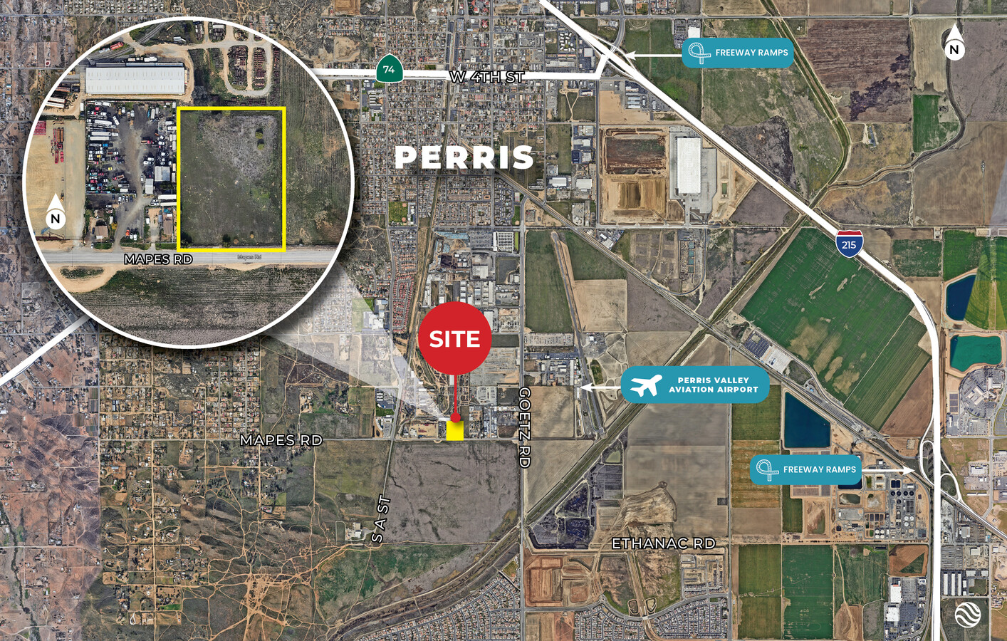
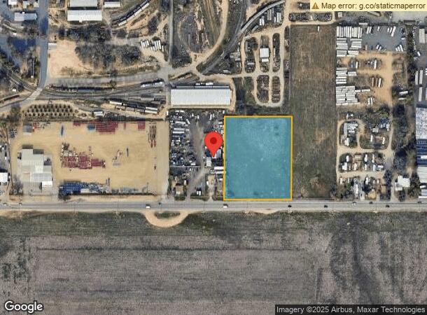
240 Mapes Rd, Perris, CA 92570
Current Lease Availabilities
NEARBY LISTINGS FOR SALE OR LEASE
Property Detail
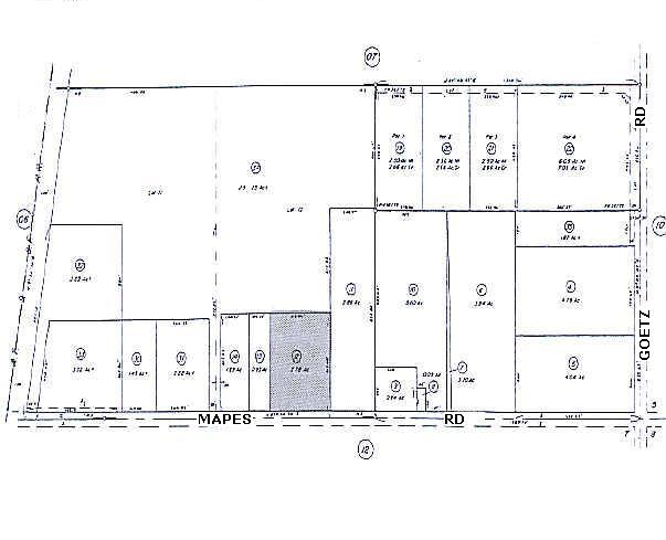
240 Mapes Rd
Riverside-San Bernardino-Ontario, CA
Sub Of S 1/2 Sec 6 T5s R3w
330-080-012
2.78 ACRES M/L IN POR LOT 12 MB 015/696 SD SUB OF S 1/2 SEC 6 T5S R3W
Commercialacreage
Riverside
X
California
06065C1440H
12
2023
2.78 AC
2023
Moreno Valley/Perris
042907
Inland Empire (California)
DEMOGRAPHICS near 240 Mapes Rd
1 Mile
3 Mile
5 Mile
2024 Total Population
3,026
48,491
124,406
2029 Population
3,233
51,830
131,558
Pop Growth 2024-2029
+ 6.84%
+ 6.89%
+ 5.75%
Average Age
34
35
37
2024 Total Households
728
13,088
36,074
HH Growth 2024-2029
+ 6.59%
+ 6.59%
+ 5.38%
Median Household Inc
$81,804
$64,736
$67,184
Avg Household Size
4.10
3.60
3.30
2024 Avg HH Vehicles
3.00
2.00
2.00
Median Home Value
$393,378
$347,935
$359,749
Median Year Built
1998
1993
1988
Nearby Places
- Restaurants
- Banks
- Shops
- Fitness
- Groceries
PUBLIC TRANSPORTATION
COMMUTER RAIL
Perris Downtown (Metrolink 91-Perris Valley Line - Metrolink Trains)
DRIVE
WALK
Distance
Perris Downtown (Metrolink 91-Perris Valley Line - Metrolink Trains)
4 min
2.5 mi
South Perris (Metrolink 91-Perris Valley Line - Metrolink Trains)
DRIVE
WALK
Distance
South Perris (Metrolink 91-Perris Valley Line - Metrolink Trains)
4 min
2.8 mi
AIRPORT
Ontario International
DRIVE
WALK
Distance
Ontario International
46 min
36.5 mi
Freight Ports
Port of Long Beach
DRIVE
WALK
Distance
Port of Long Beach
95 min
73.5 mi
Nearby Properties
Address
Land Use
TOTAL SIZE
Lot Size
Zoning
Address
Land Use
TOTAL SIZE
Lot Size
Zoning
57,600 SF
51.69 AC
Address
Land Use
TOTAL SIZE
Lot Size
Zoning
104,208 SF
10.96 AC
Address
Land Use
TOTAL SIZE
Lot Size
Zoning
75,109 SF
9.39 AC
Address
Land Use
TOTAL SIZE
Lot Size
Zoning
1,080 SF
9.53 AC
A02
Address
Land Use
TOTAL SIZE
Lot Size
Zoning
50,000 SF
5.36 AC
CC
Address
Land Use
TOTAL SIZE
Lot Size
Zoning
3,750 SF
37.79 AC
GI
Address
Land Use
TOTAL SIZE
Lot Size
Zoning
97,942 SF
11 AC
Address
Land Use
TOTAL SIZE
Lot Size
Zoning
35,600 SF
3.19 AC
Address
Land Use
TOTAL SIZE
Lot Size
Zoning
13,489 SF
6.18 AC
R3
Address
Land Use
TOTAL SIZE
Lot Size
Zoning
114,400 SF
9.88 AC
Address
Land Use
TOTAL SIZE
Lot Size
Zoning
17,976 SF
6.03 AC
Address
Land Use
TOTAL SIZE
Lot Size
Zoning
122,824 SF
5.18 AC
CC
Address
Land Use
TOTAL SIZE
Lot Size
Zoning
68,986 SF
7.21 AC
CPS
Address
Land Use
TOTAL SIZE
Lot Size
Zoning
17,776 SF
14.92 AC
Address
Land Use
TOTAL SIZE
Lot Size
Zoning
28,428 SF
1.97 AC
CICP
Address
Land Use
TOTAL SIZE
Lot Size
Zoning
24,754 SF
3.93 AC
Address
Land Use
TOTAL SIZE
Lot Size
Zoning
54,282 SF
3.87 AC
MSC
Address
Land Use
TOTAL SIZE
Lot Size
Zoning
50,625 SF
5 AC
R14
Address
Land Use
TOTAL SIZE
Lot Size
Zoning
34,496 SF
7.04 AC
R14
Address
Land Use
TOTAL SIZE
Lot Size
Zoning
27,448 SF
0.95 AC
M1
Address
Land Use
TOTAL SIZE
Lot Size
Zoning
80,158 SF
2.47 AC
DTSP
Address
Land Use
TOTAL SIZE
Lot Size
Zoning
4.80 AC
MSC
Address
Land Use
TOTAL SIZE
Lot Size
Zoning
84,699 SF
14.53 AC
C2
Address
Land Use
TOTAL SIZE
Lot Size
Zoning
71,741 SF
32.78 AC
Address
Land Use
TOTAL SIZE
Lot Size
Zoning
18,898 SF
1.69 AC
RR
The World's #1 Commercial Real Estate Marketplace
Connect with us
© 2025 CoStar Group
The information above has been obtained from sources believed reliable. While we do not doubt its accuracy we have not verified it and make no guarantee, warranty or representation about it. It is your responsibility to independently confirm its accuracy and completeness. Any projections, opinions, assumptions, or estimates used are for example only and do not represent the current or future performance of the property. The value of this transaction to you depends on tax and other factors which should be evaluated by your tax, financial, and legal advisors. You and your advisors should conduct a careful, independent investigation of the property to determine to your satisfaction the suitability of the property for your needs.