Property Record
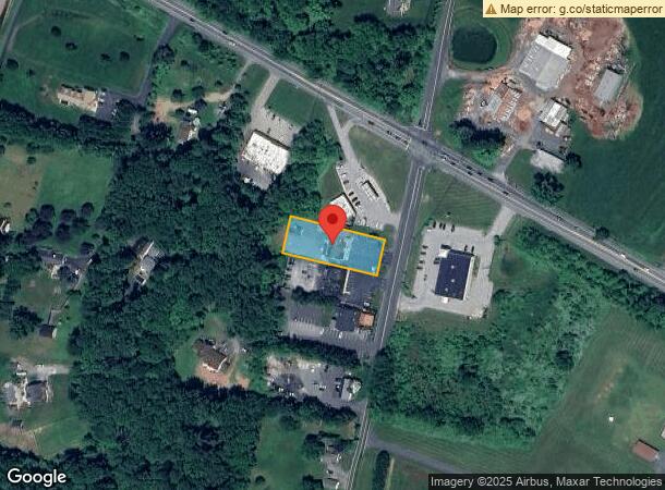
2402 Pleasantville Rd, Fallston, MD 21047
NEARBY LISTINGS FOR SALE OR LEASE
-
-
View all Fallston listings for sale on LoopNet.com
Property Detail
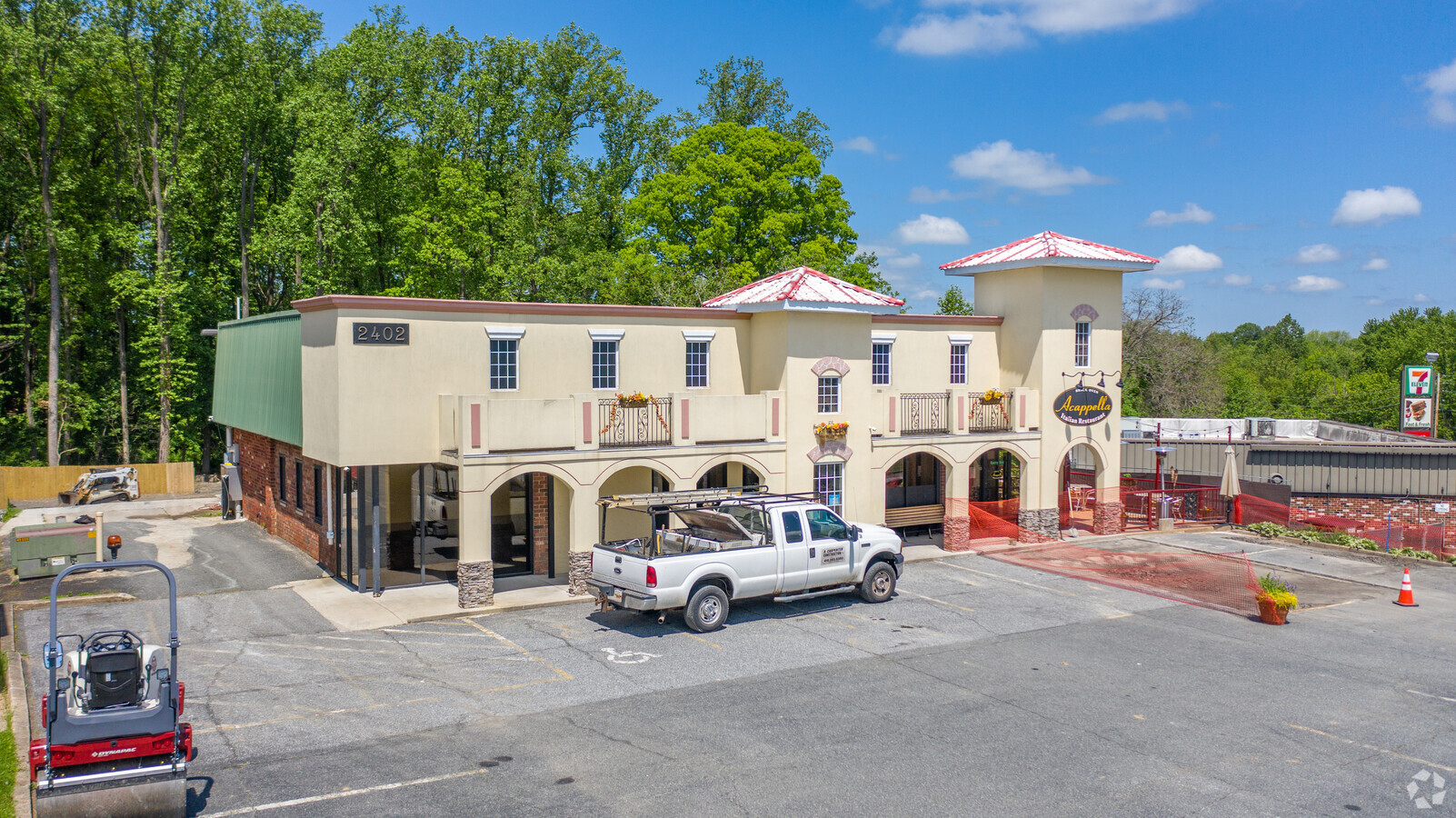
2402 Pleasantville Rd
04-041984
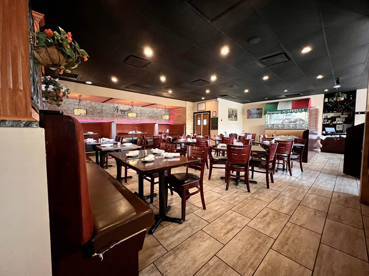
Fortunatos Restaurant
Restaurantbuilding
LOT 0.714 AC 2402 PLEASANTVILLE ROAD FORTUNATO'S RESTAURANT
X
Harford
2400100165G
Maryland
2022
0.71 AC
2024
Outlying Harford County
3042015012
Baltimore
2,976 SF
Baltimore-Columbia-Towson, MD
DEMOGRAPHICS near 2402 Pleasantville Rd
1 Mile
3 Mile
5 Mile
2024 Total Population
2,242
12,315
49,005
2029 Population
2,290
12,554
49,990
Pop Growth 2024-2029
+ 2.14%
+ 1.94%
+ 2.01%
Average Age
44
44
43
2024 Total Households
790
4,307
18,094
HH Growth 2024-2029
+ 2.15%
+ 1.95%
+ 2.06%
Median Household Inc
$138,839
$137,471
$115,323
Avg Household Size
2.80
2.80
2.60
2024 Avg HH Vehicles
3.00
3.00
2.00
Median Home Value
$456,443
$462,863
$416,634
Median Year Built
1976
1976
1982
Nearby Places
- Restaurants
- Banks
- Shops
- Fitness
- Groceries
PUBLIC TRANSPORTATION
AIRPORT
Baltimore/Washington International Thurgood Marshall
DRIVE
WALK
Distance
Baltimore/Washington International Thurgood Marshall
55 min
37.9 mi
Freight Ports
Port of Baltimore
DRIVE
WALK
Distance
Port of Baltimore
43 min
29.2 mi
SALE & LEASE HISTORY
LISTING DATE
SALE/LEASE

May 17, 2023
For Sale
Nearby Properties
Address
Land Use
TOTAL SIZE
Lot Size
Zoning
Address
Land Use
TOTAL SIZE
Lot Size
Zoning
233,500 SF
98.88 AC
AG
Address
Land Use
TOTAL SIZE
Lot Size
Zoning
4,200 SF
75.77 AC
AG
Address
Land Use
TOTAL SIZE
Lot Size
Zoning
26.18 AC
AG
Address
Land Use
TOTAL SIZE
Lot Size
Zoning
19,783 SF
6.10 AC
B1 AG
Address
Land Use
TOTAL SIZE
Lot Size
Zoning
8,679 SF
10.31 AC
AG
Address
Land Use
TOTAL SIZE
Lot Size
Zoning
5,301 SF
14.98 AC
AG
Address
Land Use
TOTAL SIZE
Lot Size
Zoning
14,136 SF
11 AC
RR AG
Address
Land Use
TOTAL SIZE
Lot Size
Zoning
10,032 SF
3.03 AC
B1
Address
Land Use
TOTAL SIZE
Lot Size
Zoning
16,920 SF
27.98 AC
AG
Address
Land Use
TOTAL SIZE
Lot Size
Zoning
1,160 SF
3.90 AC
AG
Address
Land Use
TOTAL SIZE
Lot Size
Zoning
5.01 AC
AG
Address
Land Use
TOTAL SIZE
Lot Size
Zoning
2,424 SF
19.36 AC
AG
Address
Land Use
TOTAL SIZE
Lot Size
Zoning
8,700 SF
2.14 AC
B1
Address
Land Use
TOTAL SIZE
Lot Size
Zoning
205.09 AC
AG
Address
Land Use
TOTAL SIZE
Lot Size
Zoning
180.61 AC
AG
Address
Land Use
TOTAL SIZE
Lot Size
Zoning
2,520 SF
1.13 AC
B1
Address
Land Use
TOTAL SIZE
Lot Size
Zoning
1,976 SF
1.35 AC
VB
Address
Land Use
TOTAL SIZE
Lot Size
Zoning
1,088 SF
1.44 AC
VB
Address
Land Use
TOTAL SIZE
Lot Size
Zoning
3.96 AC
RR
Address
Land Use
TOTAL SIZE
Lot Size
Zoning
5.25 AC
B3
Address
Land Use
TOTAL SIZE
Lot Size
Zoning
2,977 SF
0.86 AC
B1
Address
Land Use
TOTAL SIZE
Lot Size
Zoning
8,660 SF
0.92 AC
Address
Land Use
TOTAL SIZE
Lot Size
Zoning
4,070 SF
1.15 AC
B1
Address
Land Use
TOTAL SIZE
Lot Size
Zoning
2,483 SF
48.73 AC
B1
Address
Land Use
TOTAL SIZE
Lot Size
Zoning
1,400 SF
0.64 AC
B1
Address
Land Use
TOTAL SIZE
Lot Size
Zoning
4,826 SF
1.05 AC
BL-CR
Address
Land Use
TOTAL SIZE
Lot Size
Zoning
3,517 SF
3.24 AC
AG
Address
Land Use
TOTAL SIZE
Lot Size
Zoning
1,500 SF
3.66 AC
RR
Address
Land Use
TOTAL SIZE
Lot Size
Zoning
3,342 SF
0.88 AC
BL-CR
The World's #1 Commercial Real Estate Marketplace
Connect with us
© 2025 CoStar Group
The information above has been obtained from sources believed reliable. While we do not doubt its accuracy we have not verified it and make no guarantee, warranty or representation about it. It is your responsibility to independently confirm its accuracy and completeness. Any projections, opinions, assumptions, or estimates used are for example only and do not represent the current or future performance of the property. The value of this transaction to you depends on tax and other factors which should be evaluated by your tax, financial, and legal advisors. You and your advisors should conduct a careful, independent investigation of the property to determine to your satisfaction the suitability of the property for your needs.