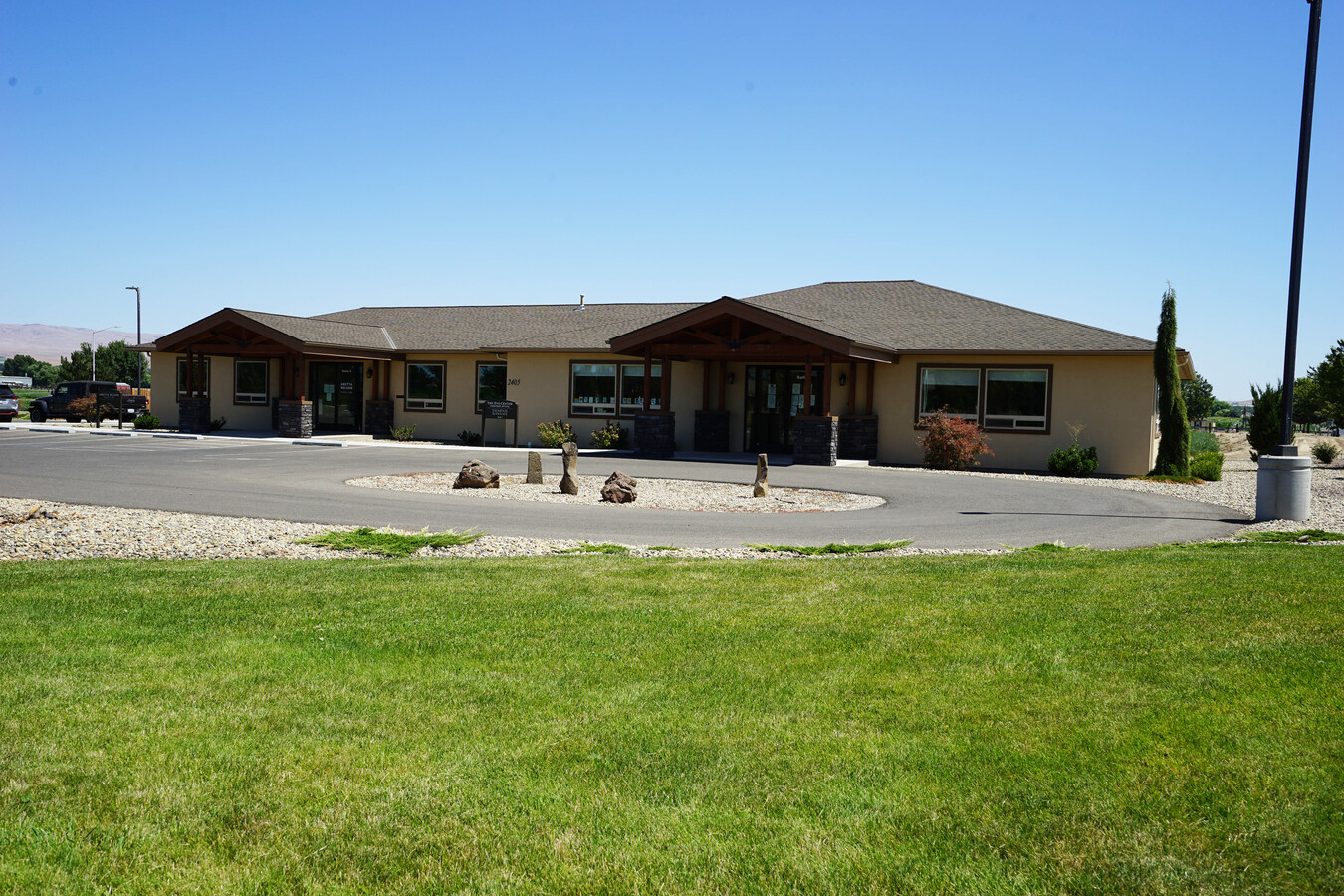
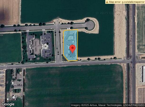
Property Record
2405 Reith Way, Sunnyside, WA 98944

NEARBY LISTINGS FOR SALE OR LEASE
Property Detail
2405 Reith Way
Yakima, WA
Of Amended Binding Site Plan As
231030-14411
SECTION 30 TOWNSHIP 10 RANGE 23 QUARTER NE: BINDING SITE PLAN AF 8008672 LOT 8-D
Commercialnec
Yakima
X
Washington
53077C1925D
8-d
2024
1.26 AC
2023
Grandview/Sunnyside
002003
Yakima
4,568 SF
DEMOGRAPHICS near 2405 Reith Way
1 Mile
3 Mile
5 Mile
2024 Total Population
1,557
20,260
24,523
2029 Population
1,554
20,296
24,491
Pop Growth 2024-2029
(0.19%)
+ 0.18%
(0.13%)
Average Age
32
32
33
2024 Total Households
459
5,710
6,942
HH Growth 2024-2029
(0.22%)
+ 0.09%
(0.23%)
Median Household Inc
$41,666
$49,904
$52,012
Avg Household Size
3.30
3.50
3.40
2024 Avg HH Vehicles
3.00
3.00
3.00
Median Home Value
$187,499
$196,278
$203,077
Median Year Built
1973
1973
1973
Nearby Places
- Restaurants
- Banks
- Shops
- Fitness
- Groceries
SALE & LEASE HISTORY
LISTING DATE
SALE/LEASE

Feb 27, 2023
For Lease
Feb 24, 2023
For Sale
Aug 03, 2021
For Lease
Nearby Properties
Address
Land Use
TOTAL SIZE
Lot Size
Zoning
Address
Land Use
TOTAL SIZE
Lot Size
Zoning
504,969 SF
75.89 AC
PF
Address
Land Use
TOTAL SIZE
Lot Size
Zoning
136,437 SF
14.46 AC
PUB
Address
Land Use
TOTAL SIZE
Lot Size
Zoning
92,281 SF
18.90 AC
R1
Address
Land Use
TOTAL SIZE
Lot Size
Zoning
76,449 SF
2.78 AC
PB
Address
Land Use
TOTAL SIZE
Lot Size
Zoning
187,651 SF
18.17 AC
M2
Address
Land Use
TOTAL SIZE
Lot Size
Zoning
272,152 SF
17.57 AC
M1
Address
Land Use
TOTAL SIZE
Lot Size
Zoning
65,578 SF
41.08 AC
R1
Address
Land Use
TOTAL SIZE
Lot Size
Zoning
155,600 SF
17.44 AC
BCOM
Address
Land Use
TOTAL SIZE
Lot Size
Zoning
224,160 SF
8.53 AC
M2
Address
Land Use
TOTAL SIZE
Lot Size
Zoning
83,940 SF
28.15 AC
R1
Address
Land Use
TOTAL SIZE
Lot Size
Zoning
17,861 SF
7.03 AC
R3
Address
Land Use
TOTAL SIZE
Lot Size
Zoning
113,242 SF
12.92 AC
M1
Address
Land Use
TOTAL SIZE
Lot Size
Zoning
133,376 SF
11.48 AC
B1
Address
Land Use
TOTAL SIZE
Lot Size
Zoning
268,860 SF
12.15 AC
M2
Address
Land Use
TOTAL SIZE
Lot Size
Zoning
36,382 SF
5 AC
R1
Address
Land Use
TOTAL SIZE
Lot Size
Zoning
110,860 SF
7.49 AC
M1
Address
Land Use
TOTAL SIZE
Lot Size
Zoning
52,132 SF
4.74 AC
R2
Address
Land Use
TOTAL SIZE
Lot Size
Zoning
134,029 SF
7.19 AC
B2
Address
Land Use
TOTAL SIZE
Lot Size
Zoning
26,021 SF
10.12 AC
PF
Address
Land Use
TOTAL SIZE
Lot Size
Zoning
50,548 SF
0.97 AC
R3
Address
Land Use
TOTAL SIZE
Lot Size
Zoning
96,195 SF
6.28 AC
B2
Address
Land Use
TOTAL SIZE
Lot Size
Zoning
15,432 SF
21.94 AC
M2
Address
Land Use
TOTAL SIZE
Lot Size
Zoning
23,570 SF
9.37 AC
M1
Address
Land Use
TOTAL SIZE
Lot Size
Zoning
39,183 SF
9.17 AC
B1
Address
Land Use
TOTAL SIZE
Lot Size
Zoning
29,120 SF
1.94 AC
R3
Address
Land Use
TOTAL SIZE
Lot Size
Zoning
50,004 SF
1.62 AC
B1
Address
Land Use
TOTAL SIZE
Lot Size
Zoning
38,396 SF
2.10 AC
BCOM
Address
Land Use
TOTAL SIZE
Lot Size
Zoning
35,146 SF
10 AC
M2
Address
Land Use
TOTAL SIZE
Lot Size
Zoning
36,882 SF
3.06 AC
R2
Address
Land Use
TOTAL SIZE
Lot Size
Zoning
37,330 SF
4.95 AC
B2
The World's #1 Commercial Real Estate Marketplace
Connect with us
© 2025 CoStar Group
The information above has been obtained from sources believed reliable. While we do not doubt its accuracy we have not verified it and make no guarantee, warranty or representation about it. It is your responsibility to independently confirm its accuracy and completeness. Any projections, opinions, assumptions, or estimates used are for example only and do not represent the current or future performance of the property. The value of this transaction to you depends on tax and other factors which should be evaluated by your tax, financial, and legal advisors. You and your advisors should conduct a careful, independent investigation of the property to determine to your satisfaction the suitability of the property for your needs.