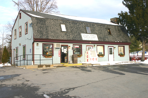
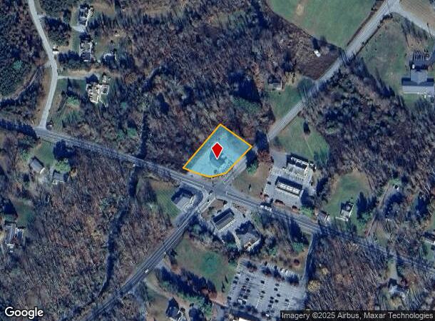
Property Record
1333 Clove Valley Rd, Hopewell Junction, NY 12533
NEARBY LISTINGS FOR SALE OR LEASE
Property Detail
1333 Clove Valley Rd
132200-6759-00-386424-0000
0.68 AC (D) 1992 0262 1909 0005
Commercialnec
Dutchess
X
New York
36027C0414E
386
2023
0.68 AC
2023
Fishkill
050203
Westchester/So Connecticut
5,244 SF
Dutchess County-Putnam County, NY
DEMOGRAPHICS near 1333 Clove Valley Rd
1 Mile
3 Mile
5 Mile
2024 Total Population
1,744
12,068
26,664
2029 Population
1,726
12,051
26,593
Pop Growth 2024-2029
(1.03%)
(0.14%)
(0.27%)
Average Age
42
42
42
2024 Total Households
637
4,317
8,666
HH Growth 2024-2029
(1.10%)
(0.16%)
(0.30%)
Median Household Inc
$133,700
$111,902
$116,551
Avg Household Size
2.70
2.70
2.80
2024 Avg HH Vehicles
2.00
2.00
2.00
Median Home Value
$425,180
$406,895
$423,409
Median Year Built
1994
1984
1982
Nearby Places
- Restaurants
- Banks
- Shops
- Fitness
- Groceries
PUBLIC TRANSPORTATION
COMMUTER RAIL
Harlem Valley-Wingdale Station (Harlem Line - Metro-North Commuter Railroad Company (Metro-North))
DRIVE
WALK
Distance
Harlem Valley-Wingdale Station (Harlem Line - Metro-North Commuter Railroad Company (Metro-North))
19 min
10.0 mi
AIRPORT
New York Stewart International
DRIVE
WALK
Distance
New York Stewart International
44 min
29.7 mi
Freight Ports
Port of New Haven
DRIVE
WALK
Distance
Port of New Haven
93 min
60.5 mi
Nearby Properties
Address
Land Use
TOTAL SIZE
Lot Size
Zoning
Address
Land Use
TOTAL SIZE
Lot Size
Zoning
100 SF
86.38 AC
TC
Address
Land Use
TOTAL SIZE
Lot Size
Zoning
13.98 AC
TC
Address
Land Use
TOTAL SIZE
Lot Size
Zoning
38,233 SF
466.58 AC
R-45
Address
Land Use
TOTAL SIZE
Lot Size
Zoning
54,004 SF
20 AC
R-45
Address
Land Use
TOTAL SIZE
Lot Size
Zoning
41,538 SF
7.18 AC
C-2
Address
Land Use
TOTAL SIZE
Lot Size
Zoning
303.09 AC
R-135
Address
Land Use
TOTAL SIZE
Lot Size
Zoning
4,611 SF
388.78 AC
RA3
Address
Land Use
TOTAL SIZE
Lot Size
Zoning
243.20 AC
R-135
Address
Land Use
TOTAL SIZE
Lot Size
Zoning
6,520 SF
109.60 AC
RD10
Address
Land Use
TOTAL SIZE
Lot Size
Zoning
12,715 SF
77.08 AC
R-45
Address
Land Use
TOTAL SIZE
Lot Size
Zoning
120,546 SF
58.90 AC
R-45
Address
Land Use
TOTAL SIZE
Lot Size
Zoning
5,280 SF
549.15 AC
RD10
Address
Land Use
TOTAL SIZE
Lot Size
Zoning
31,186 SF
9.65 AC
P-H
Address
Land Use
TOTAL SIZE
Lot Size
Zoning
153.10 AC
R-45
Address
Land Use
TOTAL SIZE
Lot Size
Zoning
100.30 AC
RD10
Address
Land Use
TOTAL SIZE
Lot Size
Zoning
9,037 SF
581.60 AC
RD10
Address
Land Use
TOTAL SIZE
Lot Size
Zoning
14,906 SF
2.40 AC
P-H
Address
Land Use
TOTAL SIZE
Lot Size
Zoning
248.48 AC
R-45
Address
Land Use
TOTAL SIZE
Lot Size
Zoning
4,160 SF
119.95 AC
R-45
Address
Land Use
TOTAL SIZE
Lot Size
Zoning
51,541 SF
17.10 AC
R-45
Address
Land Use
TOTAL SIZE
Lot Size
Zoning
3,521 SF
28.61 AC
TC
Address
Land Use
TOTAL SIZE
Lot Size
Zoning
14,044 SF
9.80 AC
R-45
Address
Land Use
TOTAL SIZE
Lot Size
Zoning
11,869 SF
50 AC
RD10
Address
Land Use
TOTAL SIZE
Lot Size
Zoning
11,900 SF
2.27 AC
C-2
Address
Land Use
TOTAL SIZE
Lot Size
Zoning
86.50 AC
R-135
Address
Land Use
TOTAL SIZE
Lot Size
Zoning
2,432 SF
194.98 AC
R-45
Address
Land Use
TOTAL SIZE
Lot Size
Zoning
288 SF
65.28 AC
R-45
Address
Land Use
TOTAL SIZE
Lot Size
Zoning
393.20 AC
RA5
Address
Land Use
TOTAL SIZE
Lot Size
Zoning
15,225 SF
1.70 AC
C-2
Address
Land Use
TOTAL SIZE
Lot Size
Zoning
51.50 AC
RA3
The World's #1 Commercial Real Estate Marketplace
Connect with us
© 2025 CoStar Group
The information above has been obtained from sources believed reliable. While we do not doubt its accuracy we have not verified it and make no guarantee, warranty or representation about it. It is your responsibility to independently confirm its accuracy and completeness. Any projections, opinions, assumptions, or estimates used are for example only and do not represent the current or future performance of the property. The value of this transaction to you depends on tax and other factors which should be evaluated by your tax, financial, and legal advisors. You and your advisors should conduct a careful, independent investigation of the property to determine to your satisfaction the suitability of the property for your needs.