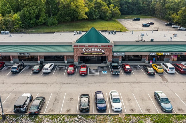
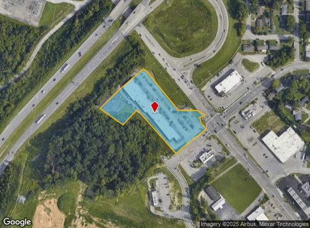
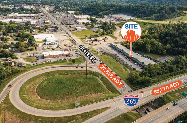
Property Record
2441 State St, New Albany, IN 47150

Current Lease Availabilities
NEARBY LISTINGS FOR SALE OR LEASE
Property Detail
2441 State St
22-05-02-700-377.004-008
Mall Development Sub
Stripcommercialcenter
P 1446 L 4 3.310AC MP 05-02-730-044.004
X
Floyd
18019C0275E
Indiana
2023
3.31 AC
2024
New Albany
070801
Louisville
29,470 SF
Louisville-Jefferson County, KY-IN
DEMOGRAPHICS near 2441 State St
1 Mile
3 Mile
5 Mile
2024 Total Population
5,847
43,871
110,645
2029 Population
5,883
44,457
112,840
Pop Growth 2024-2029
+ 0.62%
+ 1.34%
+ 1.98%
Average Age
40
40
40
2024 Total Households
2,607
18,699
45,770
HH Growth 2024-2029
+ 0.50%
+ 1.31%
+ 2.01%
Median Household Inc
$50,662
$51,060
$46,949
Avg Household Size
2.10
2.20
2.30
2024 Avg HH Vehicles
2.00
2.00
2.00
Median Home Value
$155,345
$161,868
$152,763
Median Year Built
1969
1963
1960
Nearby Places
Map Layers
Map Styles
 Street
 Aerial
- Restaurants
- Banks
- Shops
- Fitness
- Groceries
PUBLIC TRANSPORTATION
AIRPORT
Louisville Muhammad Ali International
DRIVE
WALK
Distance
Louisville Muhammad Ali International
26 min
14.3 mi
Nearby Properties
Address
Land Use
TOTAL SIZE
Lot Size
Zoning
Address
Land Use
TOTAL SIZE
Lot Size
Zoning
175,626 SF
60.10 AC
Address
Land Use
TOTAL SIZE
Lot Size
Zoning
12,270 SF
13.50 AC
Address
Land Use
TOTAL SIZE
Lot Size
Zoning
25,728 SF
10.37 AC
Address
Land Use
TOTAL SIZE
Lot Size
Zoning
4,512 SF
17.76 AC
Address
Land Use
TOTAL SIZE
Lot Size
Zoning
1.84 AC
Address
Land Use
TOTAL SIZE
Lot Size
Zoning
270,377 SF
17.54 AC
Address
Land Use
TOTAL SIZE
Lot Size
Zoning
3,692 SF
15.99 AC
Address
Land Use
TOTAL SIZE
Lot Size
Zoning
143,700 SF
0.29 AC
Address
Land Use
TOTAL SIZE
Lot Size
Zoning
202,859 SF
22.95 AC
Address
Land Use
TOTAL SIZE
Lot Size
Zoning
169 SF
35.25 AC
Address
Land Use
TOTAL SIZE
Lot Size
Zoning
34,308 SF
4.59 AC
Address
Land Use
TOTAL SIZE
Lot Size
Zoning
72,332 SF
2.48 AC
Address
Land Use
TOTAL SIZE
Lot Size
Zoning
83,084 SF
14.65 AC
Address
Land Use
TOTAL SIZE
Lot Size
Zoning
27,132 SF
4.27 AC
Address
Land Use
TOTAL SIZE
Lot Size
Zoning
272 SF
210.55 AC
Address
Land Use
TOTAL SIZE
Lot Size
Zoning
31,646 SF
5.63 AC
Address
Land Use
TOTAL SIZE
Lot Size
Zoning
35,044 SF
3.39 AC
Address
Land Use
TOTAL SIZE
Lot Size
Zoning
3,360 SF
9.40 AC
Address
Land Use
TOTAL SIZE
Lot Size
Zoning
39,851 SF
19.68 AC
Address
Land Use
TOTAL SIZE
Lot Size
Zoning
118,371 SF
11.83 AC
Address
Land Use
TOTAL SIZE
Lot Size
Zoning
75,310 SF
0.83 AC
Address
Land Use
TOTAL SIZE
Lot Size
Zoning
7,496 SF
9.37 AC
Address
Land Use
TOTAL SIZE
Lot Size
Zoning
16,088 SF
8.13 AC
Address
Land Use
TOTAL SIZE
Lot Size
Zoning
65,748 SF
4.34 AC
Address
Land Use
TOTAL SIZE
Lot Size
Zoning
42,344 SF
6.77 AC
Address
Land Use
TOTAL SIZE
Lot Size
Zoning
125,751 SF
22.59 AC
Address
Land Use
TOTAL SIZE
Lot Size
Zoning
59,998 SF
7.28 AC
Address
Land Use
TOTAL SIZE
Lot Size
Zoning
26,532 SF
1.20 AC
Address
Land Use
TOTAL SIZE
Lot Size
Zoning
75,898 SF
2.16 AC
Address
Land Use
TOTAL SIZE
Lot Size
Zoning
301,104 SF
15.74 AC
The World's #1 Commercial Real Estate Marketplace
Connect with us
© 2026 CoStar Group
The information above has been obtained from sources believed reliable. While we do not doubt its accuracy we have not verified it and make no guarantee, warranty or representation about it. It is your responsibility to independently confirm its accuracy and completeness. Any projections, opinions, assumptions, or estimates used are for example only and do not represent the current or future performance of the property. The value of this transaction to you depends on tax and other factors which should be evaluated by your tax, financial, and legal advisors. You and your advisors should conduct a careful, independent investigation of the property to determine to your satisfaction the suitability of the property for your needs.