Property Record
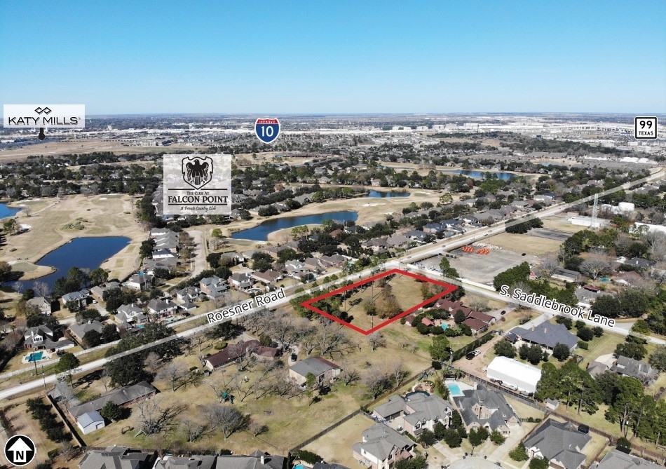
24515 Roesner Rd, Katy, TX 77494
NEARBY LISTINGS FOR SALE OR LEASE
Property Detail
24515 Roesner Rd
Houston-The Woodlands-Sugar Land, TX
I And Gn Ry
0262-03-102-0000-914
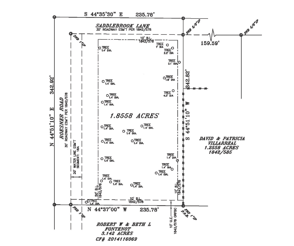
0262 I AND GN RY, TRACT 3, PARCEL 102, ACRES 1.8558, SEC 3
Residentialacreage
Fort Bend
X
Texas
48201C0595M
3,
2023
1.86 AC
2023
Katy/Grand Parkway West
673112
Houston
DEMOGRAPHICS near 24515 Roesner Rd
1 Mile
3 Mile
5 Mile
2024 Total Population
14,910
112,403
307,465
2029 Population
17,170
125,961
346,687
Pop Growth 2024-2029
+ 15.16%
+ 12.06%
+ 12.76%
Average Age
37
37
36
2024 Total Households
5,186
38,129
99,025
HH Growth 2024-2029
+ 14.40%
+ 11.69%
+ 12.53%
Median Household Inc
$109,663
$105,490
$111,228
Avg Household Size
2.80
2.90
3.10
2024 Avg HH Vehicles
2.00
2.00
2.00
Median Home Value
$358,482
$326,531
$339,658
Median Year Built
2009
2005
2007
Nearby Places
- Restaurants
- Banks
- Shops
- Fitness
- Groceries
SALE & LEASE HISTORY
LISTING DATE
SALE/LEASE

Mar 06, 2018
For Sale
Feb 14, 2022
For Sale
Aug 10, 2017
For Sale
Nearby Properties
Address
Land Use
TOTAL SIZE
Lot Size
Zoning
Address
Land Use
TOTAL SIZE
Lot Size
Zoning
39.24 AC
Address
Land Use
TOTAL SIZE
Lot Size
Zoning
1,655,920 SF
121.35 AC
Address
Land Use
TOTAL SIZE
Lot Size
Zoning
786,753 SF
116.13 AC
Address
Land Use
TOTAL SIZE
Lot Size
Zoning
610,000 SF
99.39 AC
Y
Address
Land Use
TOTAL SIZE
Lot Size
Zoning
350,883 SF
29.41 AC
Address
Land Use
TOTAL SIZE
Lot Size
Zoning
433,000 SF
59.75 AC
Address
Land Use
TOTAL SIZE
Lot Size
Zoning
Address
Land Use
TOTAL SIZE
Lot Size
Zoning
455,592 SF
27.53 AC
Address
Land Use
TOTAL SIZE
Lot Size
Zoning
352,733 SF
13.66 AC
Address
Land Use
TOTAL SIZE
Lot Size
Zoning
351,758 SF
18.23 AC
Address
Land Use
TOTAL SIZE
Lot Size
Zoning
185,815 SF
30.28 AC
Address
Land Use
TOTAL SIZE
Lot Size
Zoning
523,641 SF
17.31 AC
X
Address
Land Use
TOTAL SIZE
Lot Size
Zoning
455,592 SF
20.95 AC
Address
Land Use
TOTAL SIZE
Lot Size
Zoning
440,214 SF
23.66 AC
Address
Land Use
TOTAL SIZE
Lot Size
Zoning
348,199 SF
16.69 AC
Address
Land Use
TOTAL SIZE
Lot Size
Zoning
165,097 SF
45.40 AC
Address
Land Use
TOTAL SIZE
Lot Size
Zoning
329,094 SF
13.78 AC
Address
Land Use
TOTAL SIZE
Lot Size
Zoning
1,022 SF
21.43 AC
RAD
Address
Land Use
TOTAL SIZE
Lot Size
Zoning
481,055 SF
4.56 AC
Address
Land Use
TOTAL SIZE
Lot Size
Zoning
312,053 SF
14.11 AC
Address
Land Use
TOTAL SIZE
Lot Size
Zoning
6.13 AC
Address
Land Use
TOTAL SIZE
Lot Size
Zoning
41,083 SF
23.66 AC
Address
Land Use
TOTAL SIZE
Lot Size
Zoning
261,803 SF
12.51 AC
Address
Land Use
TOTAL SIZE
Lot Size
Zoning
21.54 AC
Address
Land Use
TOTAL SIZE
Lot Size
Zoning
Address
Land Use
TOTAL SIZE
Lot Size
Zoning
313,705 SF
14.11 AC
Address
Land Use
TOTAL SIZE
Lot Size
Zoning
317,277 SF
16.16 AC
Address
Land Use
TOTAL SIZE
Lot Size
Zoning
12.50 AC
Address
Land Use
TOTAL SIZE
Lot Size
Zoning
296,130 SF
12 AC
Address
Land Use
TOTAL SIZE
Lot Size
Zoning
174,906 SF
31.18 AC
The World's #1 Commercial Real Estate Marketplace
Connect with us
© 2025 CoStar Group
The information above has been obtained from sources believed reliable. While we do not doubt its accuracy we have not verified it and make no guarantee, warranty or representation about it. It is your responsibility to independently confirm its accuracy and completeness. Any projections, opinions, assumptions, or estimates used are for example only and do not represent the current or future performance of the property. The value of this transaction to you depends on tax and other factors which should be evaluated by your tax, financial, and legal advisors. You and your advisors should conduct a careful, independent investigation of the property to determine to your satisfaction the suitability of the property for your needs.