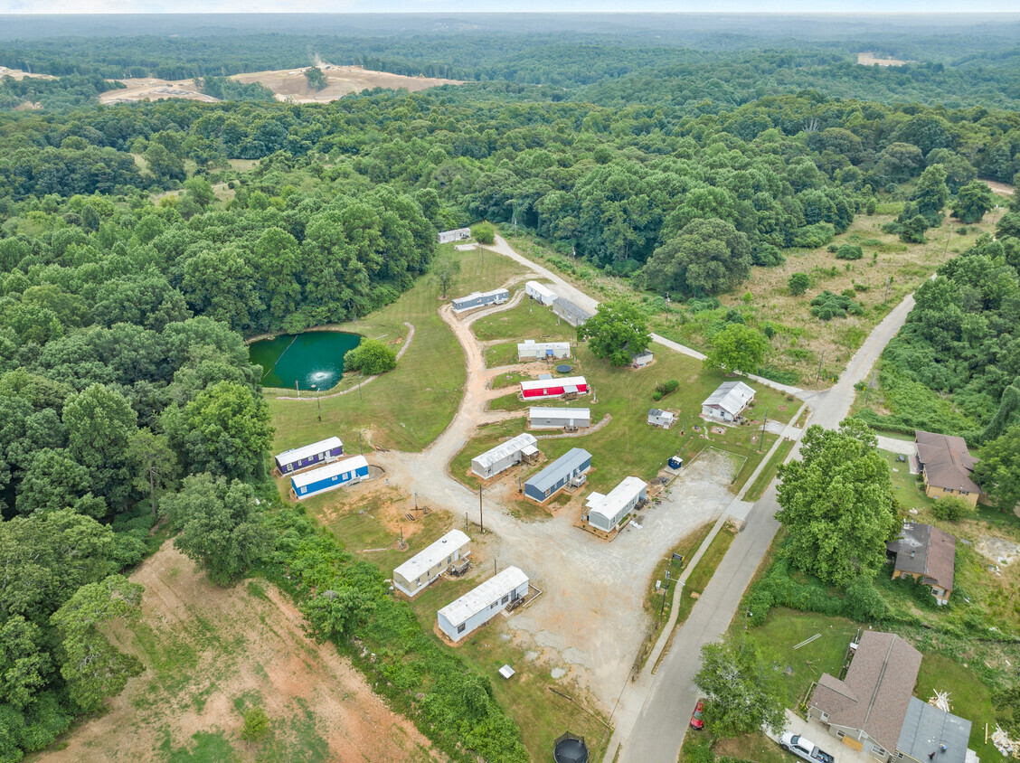
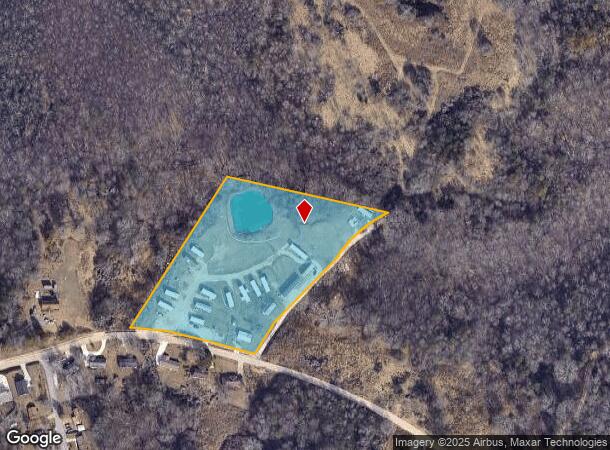
Property Record
2455 Floyd Rd, Gainesville, GA 30507


NEARBY LISTINGS FOR SALE OR LEASE
Property Detail
2455 Floyd Rd
Gainesville, GA
Hall
15-00022-00-037
Georgia
Sfr
6.93 AC
X
Gainesville/Hall County
13139C0195H
Atlanta
1,056 SF
DEMOGRAPHICS near 2455 Floyd Rd
1 Mile
3 Mile
5 Mile
2024 Total Population
3,667
26,874
63,268
2029 Population
4,070
29,685
69,379
Pop Growth 2024-2029
+ 10.99%
+ 10.46%
+ 9.66%
Average Age
34
36
36
2024 Total Households
1,084
8,913
20,702
HH Growth 2024-2029
+ 10.89%
+ 10.50%
+ 9.67%
Median Household Inc
$37,636
$45,293
$52,142
Avg Household Size
3.20
2.80
2.90
2024 Avg HH Vehicles
2.00
2.00
2.00
Median Home Value
$135,405
$185,464
$221,465
Median Year Built
1990
1986
1988
Nearby Places
- Restaurants
- Banks
- Shops
- Fitness
- Groceries
PUBLIC TRANSPORTATION
COMMUTER RAIL
Gainesville Amtrak Station (Crescent - Amtrak)
DRIVE
WALK
Distance
Gainesville Amtrak Station (Crescent - Amtrak)
8 min
3.7 mi
Freight Ports
Georgia Ports - Savannah
DRIVE
WALK
Distance
Georgia Ports - Savannah
317 min
249.9 mi
SALE & LEASE HISTORY
LISTING DATE
SALE/LEASE

Jul 09, 2024
For Sale
Nearby Properties
Address
Land Use
TOTAL SIZE
Lot Size
Zoning
Address
Land Use
TOTAL SIZE
Lot Size
Zoning
564,132 SF
48.45 AC
EX
Address
Land Use
TOTAL SIZE
Lot Size
Zoning
39,637 SF
31.55 AC
R-II
Address
Land Use
TOTAL SIZE
Lot Size
Zoning
34,131 SF
80.82 AC
L-I
Address
Land Use
TOTAL SIZE
Lot Size
Zoning
44,052 SF
19.19 AC
PUD
Address
Land Use
TOTAL SIZE
Lot Size
Zoning
27,221 SF
2.23 AC
G-B
Address
Land Use
TOTAL SIZE
Lot Size
Zoning
2,160 SF
5.60 AC
PUD
Address
Land Use
TOTAL SIZE
Lot Size
Zoning
3,284 SF
28.53 AC
PUD
Address
Land Use
TOTAL SIZE
Lot Size
Zoning
77,333 SF
11.74 AC
G-B
Address
Land Use
TOTAL SIZE
Lot Size
Zoning
2,038 SF
20.92 AC
R-II
Address
Land Use
TOTAL SIZE
Lot Size
Zoning
76,726 SF
0.42 AC
C-B
Address
Land Use
TOTAL SIZE
Lot Size
Zoning
100,864 SF
4.10 AC
PUD
Address
Land Use
TOTAL SIZE
Lot Size
Zoning
6,852 SF
3.15 AC
PUD
Address
Land Use
TOTAL SIZE
Lot Size
Zoning
46,795 SF
17.38 AC
PUD
Address
Land Use
TOTAL SIZE
Lot Size
Zoning
102,317 SF
6.90 AC
PUD
Address
Land Use
TOTAL SIZE
Lot Size
Zoning
128,531 SF
13.32 AC
R-I
Address
Land Use
TOTAL SIZE
Lot Size
Zoning
148,619 SF
30.75 AC
L-I
Address
Land Use
TOTAL SIZE
Lot Size
Zoning
1,441 SF
10.46 AC
R-II
Address
Land Use
TOTAL SIZE
Lot Size
Zoning
82,610 SF
13.68 AC
H-B
Address
Land Use
TOTAL SIZE
Lot Size
Zoning
4,032 SF
89.43 AC
R-I
Address
Land Use
TOTAL SIZE
Lot Size
Zoning
140,805 SF
3.74 AC
G-B
Address
Land Use
TOTAL SIZE
Lot Size
Zoning
67,383 SF
1.68 AC
C-B
Address
Land Use
TOTAL SIZE
Lot Size
Zoning
69,888 SF
5.37 AC
O-I
Address
Land Use
TOTAL SIZE
Lot Size
Zoning
12,200 SF
0.30 AC
C-B
Address
Land Use
TOTAL SIZE
Lot Size
Zoning
60,062 SF
0.51 AC
C-B
Address
Land Use
TOTAL SIZE
Lot Size
Zoning
6.23 AC
R-II
Address
Land Use
TOTAL SIZE
Lot Size
Zoning
97,660 SF
7.17 AC
Address
Land Use
TOTAL SIZE
Lot Size
Zoning
194,850 SF
13.58 AC
I-I
Address
Land Use
TOTAL SIZE
Lot Size
Zoning
16,388 SF
5.16 AC
G-B
Address
Land Use
TOTAL SIZE
Lot Size
Zoning
231,966 SF
0.95 AC
C-B
Address
Land Use
TOTAL SIZE
Lot Size
Zoning
24,097 SF
1.85 AC
G-B
The World's #1 Commercial Real Estate Marketplace
Connect with us
© 2025 CoStar Group
The information above has been obtained from sources believed reliable. While we do not doubt its accuracy we have not verified it and make no guarantee, warranty or representation about it. It is your responsibility to independently confirm its accuracy and completeness. Any projections, opinions, assumptions, or estimates used are for example only and do not represent the current or future performance of the property. The value of this transaction to you depends on tax and other factors which should be evaluated by your tax, financial, and legal advisors. You and your advisors should conduct a careful, independent investigation of the property to determine to your satisfaction the suitability of the property for your needs.