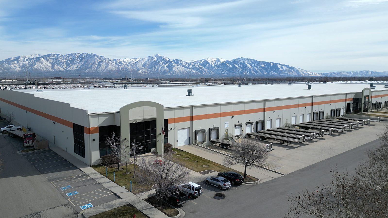
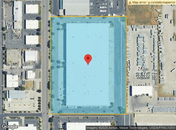
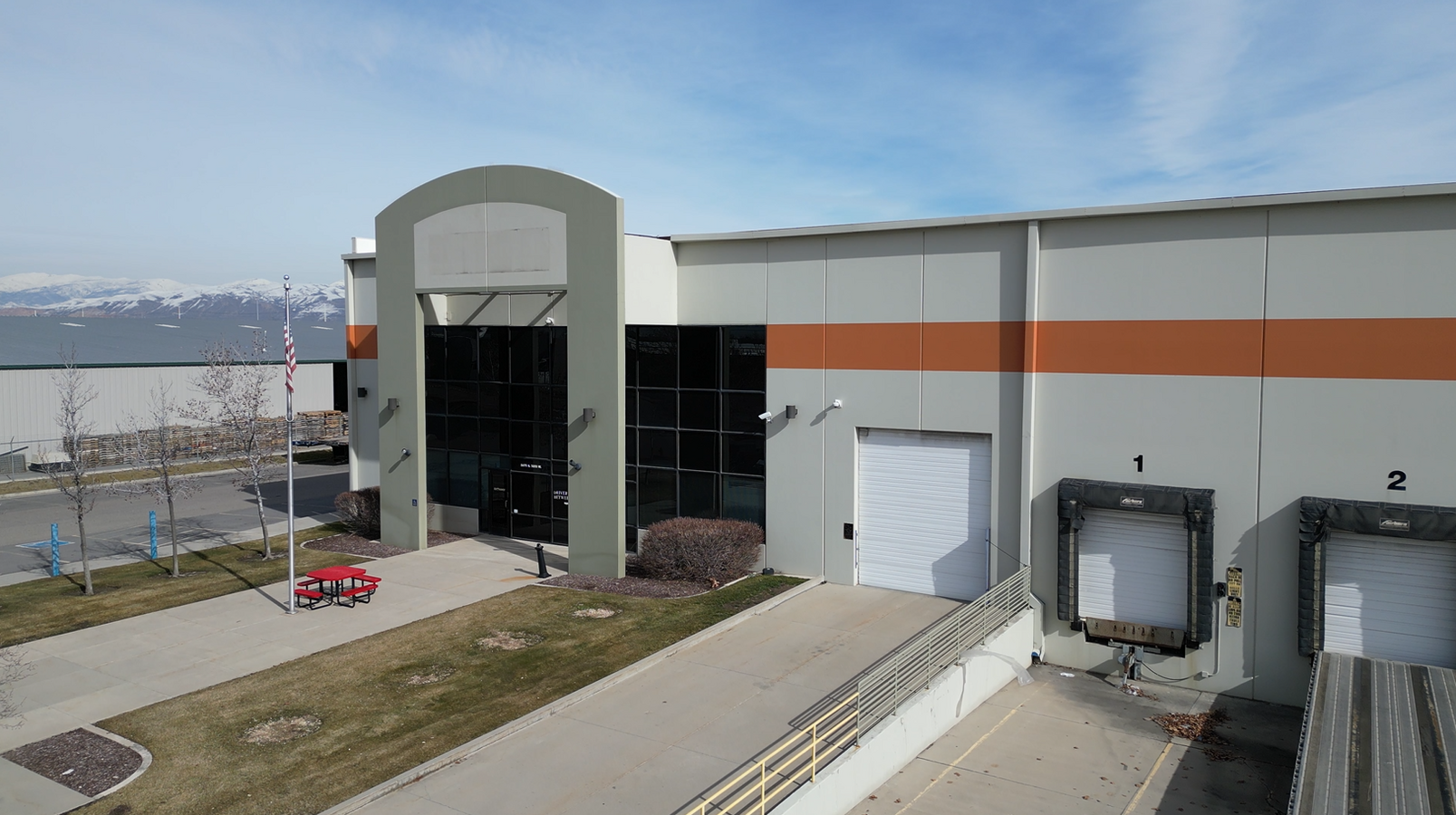
Property Record
2475 S 3200 W, West Valley City, UT 84119
NEARBY LISTINGS FOR SALE OR LEASE
Property Detail
2475 S 3200 W
15-21-301-005-0000
Pratezk Industrial Park Plat 4
Warehouse
BEG S 0^0425 E 330 FT & N 89^5512 E 50 FT FR W 1/4 COR SEC 21, T 1S, R 1W, SLM; S 89^5428 E 782.06 FT; S 0^0506E 997.88 FT; N 89^5912 W 782.25 FT; N 0^0425 W 998.96 FTTO BEG. 17.92 AC. 3955-0005,0007 5970-0351 8285-4089 8394-2119 8927-0681 8971-7384
X
Salt Lake
49035C0280E
Utah
2023
17.92 AC
2023
West Valley
113307
Salt Lake City
367,984 SF
Salt Lake City, UT
DEMOGRAPHICS near 2475 S 3200 W
1 Mile
3 Mile
5 Mile
2024 Total Population
8,255
89,934
291,639
2029 Population
8,228
90,294
295,361
Pop Growth 2024-2029
(0.33%)
+ 0.40%
+ 1.28%
Average Age
33
35
36
2024 Total Households
2,264
27,567
98,799
HH Growth 2024-2029
(0.40%)
+ 0.43%
+ 1.46%
Median Household Inc
$64,201
$65,561
$63,609
Avg Household Size
3.40
3.10
2.80
2024 Avg HH Vehicles
2.00
2.00
2.00
Median Home Value
$210,152
$312,534
$340,441
Median Year Built
1977
1979
1980
Nearby Places
- Restaurants
- Banks
- Shops
- Fitness
- Groceries
PUBLIC TRANSPORTATION
COMMUTER RAIL
North Temple Station (FrontRunner - Utah Transit Authority (UTA))
DRIVE
WALK
Distance
North Temple Station (FrontRunner - Utah Transit Authority (UTA))
15 min
8.1 mi
Warm Springs Relief Point (FrontRunner - Utah Transit Authority (UTA))
DRIVE
WALK
Distance
Warm Springs Relief Point (FrontRunner - Utah Transit Authority (UTA))
16 min
9.4 mi
AIRPORT
Salt Lake City International
DRIVE
WALK
Distance
Salt Lake City International
11 min
6.0 mi
Freight Ports
Port of Stockton
DRIVE
WALK
Distance
Port of Stockton
710 min
692.6 mi
SALE & LEASE HISTORY
LISTING DATE
SALE/LEASE

Nov 06, 2017
For Lease
Feb 26, 2024
For Lease
Dec 05, 2023
For Lease
Apr 19, 2024
For Lease
Nearby Properties
Address
Land Use
TOTAL SIZE
Lot Size
Zoning
Address
Land Use
TOTAL SIZE
Lot Size
Zoning
488,509 SF
36.03 AC
FLEX
Address
Land Use
TOTAL SIZE
Lot Size
Zoning
488,509 SF
36.15 AC
LT-IND
Address
Land Use
TOTAL SIZE
Lot Size
Zoning
185,436 SF
25.23 AC
RM
Address
Land Use
TOTAL SIZE
Lot Size
Zoning
828,265 SF
9.06 AC
RM
Address
Land Use
TOTAL SIZE
Lot Size
Zoning
322,076 SF
16.32 AC
PL
Address
Land Use
TOTAL SIZE
Lot Size
Zoning
432,730 SF
13.03 AC
R-M
Address
Land Use
TOTAL SIZE
Lot Size
Zoning
690,542 SF
35.75 AC
M-1
Address
Land Use
TOTAL SIZE
Lot Size
Zoning
76,096 SF
17.30 AC
RM
Address
Land Use
TOTAL SIZE
Lot Size
Zoning
545,061 SF
38.41 AC
M
Address
Land Use
TOTAL SIZE
Lot Size
Zoning
436,903 SF
27.09 AC
M-1
Address
Land Use
TOTAL SIZE
Lot Size
Zoning
289,725 SF
8.42 AC
1108
Address
Land Use
TOTAL SIZE
Lot Size
Zoning
505,079 SF
30.07 AC
M-1
Address
Land Use
TOTAL SIZE
Lot Size
Zoning
482,870 SF
31.13 AC
M-1
Address
Land Use
TOTAL SIZE
Lot Size
Zoning
426,280 SF
19.84 AC
M1
Address
Land Use
TOTAL SIZE
Lot Size
Zoning
116,268 SF
8.07 AC
RMF-45
Address
Land Use
TOTAL SIZE
Lot Size
Zoning
475,592 SF
24.09 AC
M-1
Address
Land Use
TOTAL SIZE
Lot Size
Zoning
505,079 SF
25.87 AC
M-1
Address
Land Use
TOTAL SIZE
Lot Size
Zoning
131,460 SF
75.92 AC
R-1-10
Address
Land Use
TOTAL SIZE
Lot Size
Zoning
29.13 AC
C-2
Address
Land Use
TOTAL SIZE
Lot Size
Zoning
89,239 SF
14.78 AC
RM
Address
Land Use
TOTAL SIZE
Lot Size
Zoning
603,730 SF
31.77 AC
PO
Address
Land Use
TOTAL SIZE
Lot Size
Zoning
180,383 SF
4.77 AC
MXD
Address
Land Use
TOTAL SIZE
Lot Size
Zoning
46,874 SF
16.35 AC
RM
Address
Land Use
TOTAL SIZE
Lot Size
Zoning
398,192 SF
2.88 AC
CC
Address
Land Use
TOTAL SIZE
Lot Size
Zoning
393,809 SF
2.86 AC
CC
Address
Land Use
TOTAL SIZE
Lot Size
Zoning
491,507 SF
28.28 AC
M-1
Address
Land Use
TOTAL SIZE
Lot Size
Zoning
436,875 SF
26.95 AC
M-1
Address
Land Use
TOTAL SIZE
Lot Size
Zoning
482,768 SF
22.90 AC
M-1
Address
Land Use
TOTAL SIZE
Lot Size
Zoning
74,439 SF
27.33 AC
M
Address
Land Use
TOTAL SIZE
Lot Size
Zoning
431,400 SF
23.99 AC
IP-M-1
The World's #1 Commercial Real Estate Marketplace
Connect with us
© 2025 CoStar Group
The information above has been obtained from sources believed reliable. While we do not doubt its accuracy we have not verified it and make no guarantee, warranty or representation about it. It is your responsibility to independently confirm its accuracy and completeness. Any projections, opinions, assumptions, or estimates used are for example only and do not represent the current or future performance of the property. The value of this transaction to you depends on tax and other factors which should be evaluated by your tax, financial, and legal advisors. You and your advisors should conduct a careful, independent investigation of the property to determine to your satisfaction the suitability of the property for your needs.