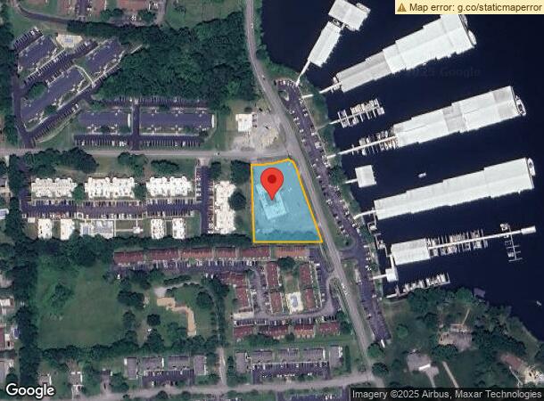
Property Record
248 Sanders Ferry Rd, Hendersonville, TN 37075


NEARBY LISTINGS FOR SALE OR LEASE
Property Detail
248 Sanders Ferry Rd
Nashville-Davidson--Murfreesboro--Franklin, TN
Kimberly Manor
164P-C-025.00
PLAT: 0006 PAGE: 0042 BLOCK: LOT: P/O1 SUBD: KIMBERLY MANOR
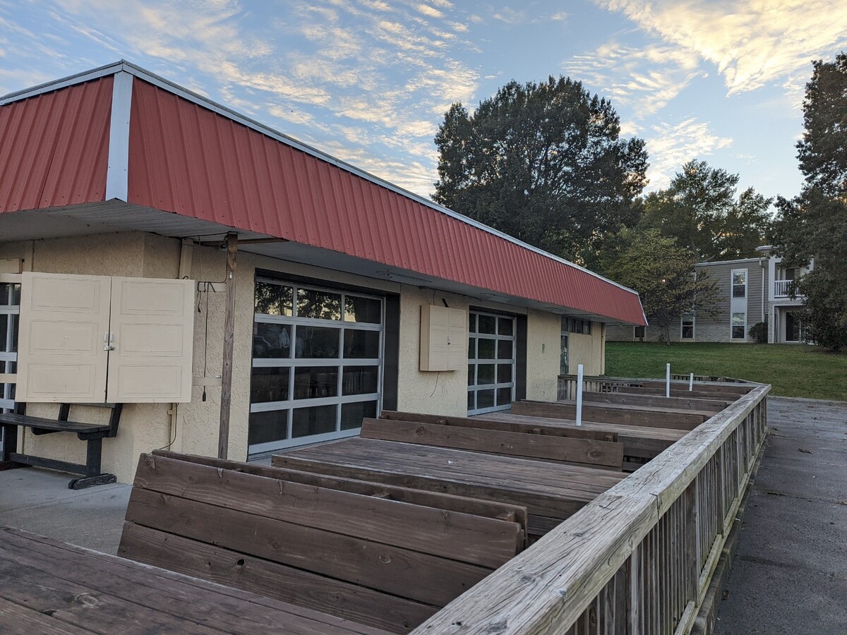
Restaurantbuilding
Sumner
X
Tennessee
47165C0411G
p/o1
2023
1.30 AC
2023
Hendersonville-Gallatin
021107
Nashville
9,546 SF
DEMOGRAPHICS near 248 Sanders Ferry Rd
1 Mile
3 Mile
5 Mile
2024 Total Population
8,354
45,029
104,441
2029 Population
9,352
49,643
113,164
Pop Growth 2024-2029
+ 11.95%
+ 10.25%
+ 8.35%
Average Age
42
41
41
2024 Total Households
3,697
17,999
41,166
HH Growth 2024-2029
+ 12.31%
+ 10.40%
+ 8.15%
Median Household Inc
$69,595
$71,113
$73,952
Avg Household Size
2.20
2.40
2.50
2024 Avg HH Vehicles
2.00
2.00
2.00
Median Home Value
$300,966
$327,118
$337,651
Median Year Built
1978
1981
1986
Nearby Places
- Restaurants
- Banks
- Shops
- Fitness
- Groceries
PUBLIC TRANSPORTATION
AIRPORT
Nashville International
DRIVE
WALK
Distance
Nashville International
37 min
27.4 mi
Freight Ports
Port of Mobile
DRIVE
WALK
Distance
Port of Mobile
510 min
465.0 mi
SALE & LEASE HISTORY
LISTING DATE
SALE/LEASE

Nov 02, 2021
For Sale
Nearby Properties
Address
Land Use
TOTAL SIZE
Lot Size
Zoning
Address
Land Use
TOTAL SIZE
Lot Size
Zoning
56,782 SF
11.37 AC
Address
Land Use
TOTAL SIZE
Lot Size
Zoning
46,650 SF
17.41 AC
MRO
Address
Land Use
TOTAL SIZE
Lot Size
Zoning
31,919 SF
14.69 AC
Address
Land Use
TOTAL SIZE
Lot Size
Zoning
191,733 SF
62.90 AC
MULTI-ZONE
Address
Land Use
TOTAL SIZE
Lot Size
Zoning
29,068 SF
13.30 AC
TCR
Address
Land Use
TOTAL SIZE
Lot Size
Zoning
32,481 SF
9.42 AC
GCS
Address
Land Use
TOTAL SIZE
Lot Size
Zoning
68,131 SF
4.16 AC
MUL
Address
Land Use
TOTAL SIZE
Lot Size
Zoning
218,472 SF
27.08 AC
GCS
Address
Land Use
TOTAL SIZE
Lot Size
Zoning
105,942 SF
14.80 AC
GCS
Address
Land Use
TOTAL SIZE
Lot Size
Zoning
18,342 SF
8.40 AC
RM1
Address
Land Use
TOTAL SIZE
Lot Size
Zoning
20,896 SF
17.79 AC
Address
Land Use
TOTAL SIZE
Lot Size
Zoning
15,456 SF
23.18 AC
Address
Land Use
TOTAL SIZE
Lot Size
Zoning
2,560 SF
2.86 AC
R15
Address
Land Use
TOTAL SIZE
Lot Size
Zoning
6,632 SF
9.47 AC
Address
Land Use
TOTAL SIZE
Lot Size
Zoning
15,105 SF
13.35 AC
Address
Land Use
TOTAL SIZE
Lot Size
Zoning
67,473 SF
2.92 AC
Address
Land Use
TOTAL SIZE
Lot Size
Zoning
18,762 SF
13.02 AC
Address
Land Use
TOTAL SIZE
Lot Size
Zoning
120,846 SF
15.03 AC
GCS
Address
Land Use
TOTAL SIZE
Lot Size
Zoning
154,556 SF
16.26 AC
Address
Land Use
TOTAL SIZE
Lot Size
Zoning
11,274 SF
15.30 AC
Address
Land Use
TOTAL SIZE
Lot Size
Zoning
4,712 SF
7.90 AC
Address
Land Use
TOTAL SIZE
Lot Size
Zoning
61,399 SF
2.97 AC
GCS
Address
Land Use
TOTAL SIZE
Lot Size
Zoning
317,625 SF
30.98 AC
Address
Land Use
TOTAL SIZE
Lot Size
Zoning
8,060 SF
13.37 AC
Address
Land Use
TOTAL SIZE
Lot Size
Zoning
82,800 SF
20 AC
IR
Address
Land Use
TOTAL SIZE
Lot Size
Zoning
29,716 SF
8.16 AC
GCS
Address
Land Use
TOTAL SIZE
Lot Size
Zoning
57,712 SF
8 AC
Address
Land Use
TOTAL SIZE
Lot Size
Zoning
13,616 SF
6.17 AC
TC-C
Address
Land Use
TOTAL SIZE
Lot Size
Zoning
69,898 SF
7.71 AC
GCS
Address
Land Use
TOTAL SIZE
Lot Size
Zoning
35,486 SF
2.56 AC
GCS
The World's #1 Commercial Real Estate Marketplace
Connect with us
© 2025 CoStar Group
The information above has been obtained from sources believed reliable. While we do not doubt its accuracy we have not verified it and make no guarantee, warranty or representation about it. It is your responsibility to independently confirm its accuracy and completeness. Any projections, opinions, assumptions, or estimates used are for example only and do not represent the current or future performance of the property. The value of this transaction to you depends on tax and other factors which should be evaluated by your tax, financial, and legal advisors. You and your advisors should conduct a careful, independent investigation of the property to determine to your satisfaction the suitability of the property for your needs.