Property Record
2482 Highway 50, Rosebud, MO 63091
NEARBY LISTINGS FOR SALE OR LEASE
-
-
View all Rosebud listings for sale on LoopNet.com
Property Detail
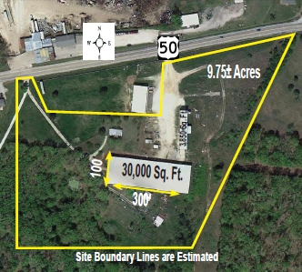
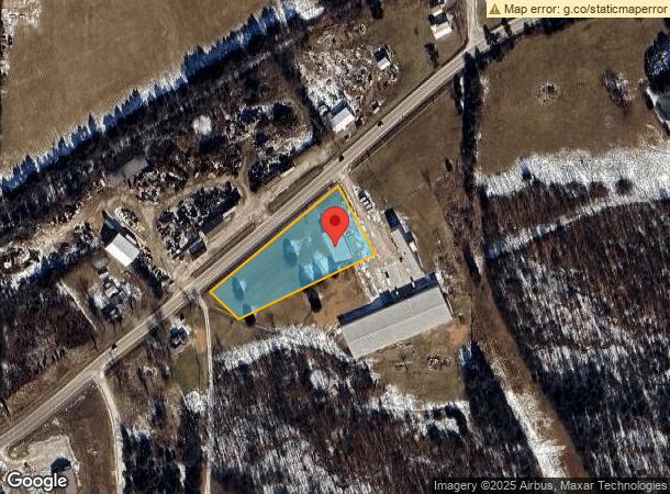
2482 Highway 50
Miscellaneous
Town Johnson
X
PT SE SE, S OF HWY 50: AC-1.64
29071C0250D
Gasconade
2024
Missouri
2024
1.64 AC
960500
Other Market Areas
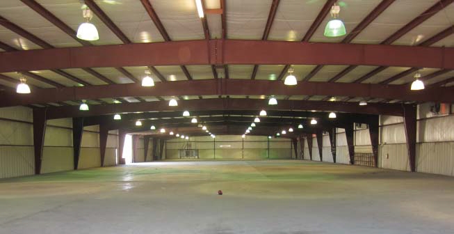
5,000 SF
13-2.0-09-000-000-008.000
DEMOGRAPHICS near 2482 Highway 50
1 Mile
3 Mile
5 Mile
2024 Total Population
42
2,463
3,673
2029 Population
42
2,519
3,755
Pop Growth 2024-2029
0.00%
+ 2.27%
+ 2.23%
Average Age
41
42
42
2024 Total Households
16
981
1,453
HH Growth 2024-2029
+ 6.25%
+ 2.34%
+ 2.27%
Median Household Inc
$71,249
$69,795
$67,349
Avg Household Size
2.40
2.40
2.50
2024 Avg HH Vehicles
2.00
3.00
2.00
Median Home Value
$225,000
$201,515
$193,864
Median Year Built
1977
1976
1976
Nearby Places
- Restaurants
- Banks
- Shops
- Fitness
- Groceries
SALE & LEASE HISTORY
LISTING DATE
SALE/LEASE

Sep 24, 2016
For Sale
Nearby Properties
Address
Land Use
TOTAL SIZE
Lot Size
Zoning
Address
Land Use
TOTAL SIZE
Lot Size
Zoning
51,018 SF
6.30 AC
Address
Land Use
TOTAL SIZE
Lot Size
Zoning
12,200 SF
0.80 AC
Address
Land Use
TOTAL SIZE
Lot Size
Zoning
735 SF
5 AC
Address
Land Use
TOTAL SIZE
Lot Size
Zoning
2,033 SF
1 AC
Address
Land Use
TOTAL SIZE
Lot Size
Zoning
11,221 SF
19 AC
CD
Address
Land Use
TOTAL SIZE
Lot Size
Zoning
3,200 SF
5.10 AC
Address
Land Use
TOTAL SIZE
Lot Size
Zoning
1,350 SF
71 AC
Address
Land Use
TOTAL SIZE
Lot Size
Zoning
6,000 SF
29 AC
Address
Land Use
TOTAL SIZE
Lot Size
Zoning
5,481 SF
1.60 AC
Address
Land Use
TOTAL SIZE
Lot Size
Zoning
5,588 SF
0.70 AC
Address
Land Use
TOTAL SIZE
Lot Size
Zoning
99.23 AC
Address
Land Use
TOTAL SIZE
Lot Size
Zoning
5,347 SF
0.30 AC
Address
Land Use
TOTAL SIZE
Lot Size
Zoning
20,160 SF
4.50 AC
Address
Land Use
TOTAL SIZE
Lot Size
Zoning
4,089 SF
0.80 AC
Address
Land Use
TOTAL SIZE
Lot Size
Zoning
80,000 SF
10 AC
ANU
Address
Land Use
TOTAL SIZE
Lot Size
Zoning
3,239 SF
5.20 AC
Address
Land Use
TOTAL SIZE
Lot Size
Zoning
4,385 SF
1 AC
Address
Land Use
TOTAL SIZE
Lot Size
Zoning
1.10 AC
Address
Land Use
TOTAL SIZE
Lot Size
Zoning
13.50 AC
CD
Address
Land Use
TOTAL SIZE
Lot Size
Zoning
4,752 SF
0.20 AC
Address
Land Use
TOTAL SIZE
Lot Size
Zoning
8.80 AC
Address
Land Use
TOTAL SIZE
Lot Size
Zoning
48,750 SF
10 AC
Address
Land Use
TOTAL SIZE
Lot Size
Zoning
5,192 SF
3.10 AC
Address
Land Use
TOTAL SIZE
Lot Size
Zoning
54,195 SF
5.10 AC
CD
Address
Land Use
TOTAL SIZE
Lot Size
Zoning
80,000 SF
10 AC
Address
Land Use
TOTAL SIZE
Lot Size
Zoning
16,817 SF
2.80 AC
Address
Land Use
TOTAL SIZE
Lot Size
Zoning
7,200 SF
3.73 AC
Address
Land Use
TOTAL SIZE
Lot Size
Zoning
3,450 SF
0.10 AC
Address
Land Use
TOTAL SIZE
Lot Size
Zoning
1,740 SF
3.90 AC
Address
Land Use
TOTAL SIZE
Lot Size
Zoning
The World's #1 Commercial Real Estate Marketplace
Connect with us
© 2025 CoStar Group
The information above has been obtained from sources believed reliable. While we do not doubt its accuracy we have not verified it and make no guarantee, warranty or representation about it. It is your responsibility to independently confirm its accuracy and completeness. Any projections, opinions, assumptions, or estimates used are for example only and do not represent the current or future performance of the property. The value of this transaction to you depends on tax and other factors which should be evaluated by your tax, financial, and legal advisors. You and your advisors should conduct a careful, independent investigation of the property to determine to your satisfaction the suitability of the property for your needs.