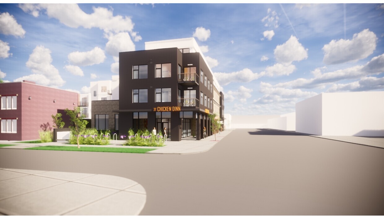
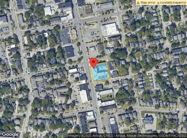
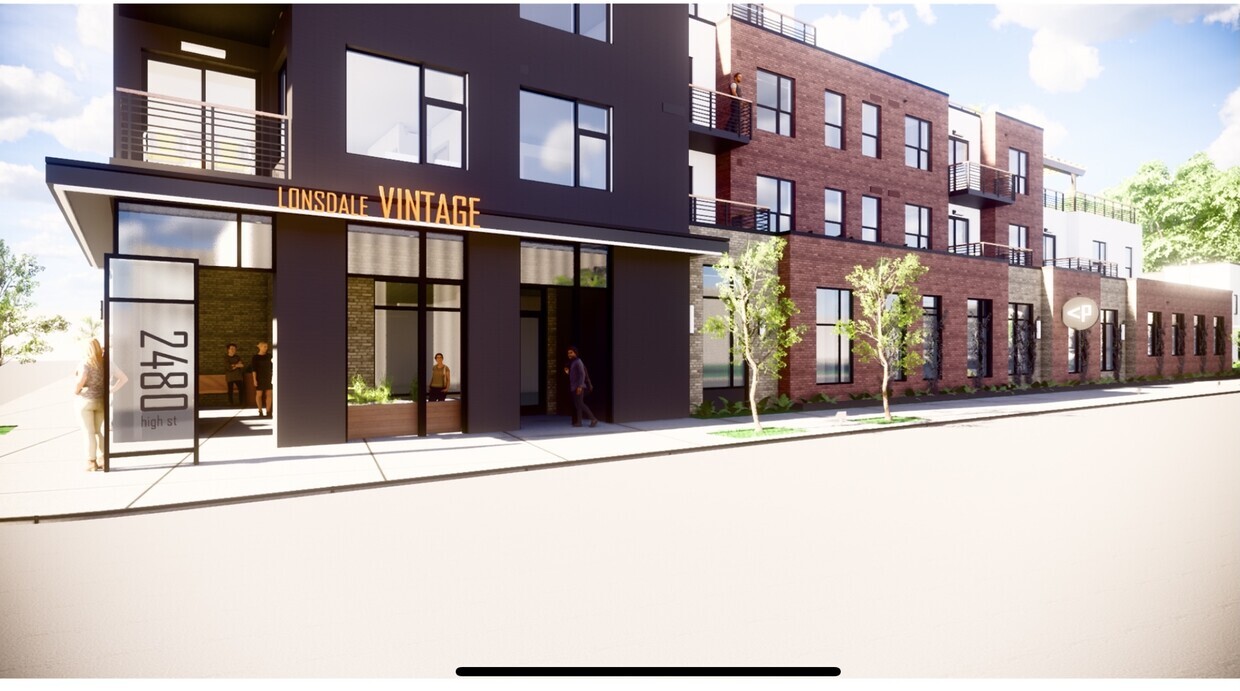
Property Record
2490 N High St, Columbus, OH 43202
NEARBY LISTINGS FOR SALE OR LEASE
Property Detail
2490 N High St
Columbus, OH
Samuel Kinnears East Add
010-045644
SE COR E TOMPKINS & N HIGH STREETS R18 T1 1/4TWP3 165 X 163.25 ON WILCOX ST
Storebuilding
Franklin
2023
Ohio
2023
0.62 AC
000600
Old North Columbus
153,291 SF
Columbus
DEMOGRAPHICS near 2490 N High St
1 Mile
3 Mile
5 Mile
2024 Total Population
32,812
170,029
375,444
2029 Population
33,046
170,982
378,327
Pop Growth 2024-2029
+ 0.71%
+ 0.56%
+ 0.77%
Average Age
28
34
36
2024 Total Households
11,700
74,293
163,806
HH Growth 2024-2029
+ 1.02%
+ 0.48%
+ 0.80%
Median Household Inc
$41,414
$58,261
$58,152
Avg Household Size
2.10
2.10
2.10
2024 Avg HH Vehicles
2.00
2.00
2.00
Median Home Value
$264,711
$309,893
$287,253
Median Year Built
1961
1959
1964
Nearby Places
- Restaurants
- Banks
- Shops
- Fitness
- Groceries
PUBLIC TRANSPORTATION
AIRPORT
John Glenn Columbus International
DRIVE
WALK
Distance
John Glenn Columbus International
15 min
9.5 mi
Rickenbacker International
DRIVE
WALK
Distance
Rickenbacker International
28 min
18.6 mi
Freight Ports
Port of Toledo
DRIVE
WALK
Distance
Port of Toledo
180 min
141.5 mi
Nearby Properties
Address
Land Use
TOTAL SIZE
Lot Size
Zoning
Address
Land Use
TOTAL SIZE
Lot Size
Zoning
3,462,019 SF
54.42 AC
Address
Land Use
TOTAL SIZE
Lot Size
Zoning
3,094,929 SF
328.10 AC
Address
Land Use
TOTAL SIZE
Lot Size
Zoning
344,620 SF
296.23 AC
Address
Land Use
TOTAL SIZE
Lot Size
Zoning
382,270 SF
319.59 AC
Address
Land Use
TOTAL SIZE
Lot Size
Zoning
Address
Land Use
TOTAL SIZE
Lot Size
Zoning
1,099,074 SF
39.12 AC
Address
Land Use
TOTAL SIZE
Lot Size
Zoning
1,504,872 SF
1.23 AC
Address
Land Use
TOTAL SIZE
Lot Size
Zoning
892,861 SF
5.26 AC
Address
Land Use
TOTAL SIZE
Lot Size
Zoning
1.64 AC
Address
Land Use
TOTAL SIZE
Lot Size
Zoning
594,403 SF
63.19 AC
Address
Land Use
TOTAL SIZE
Lot Size
Zoning
1,833,759 SF
32.89 AC
Address
Land Use
TOTAL SIZE
Lot Size
Zoning
378,522 SF
41.13 AC
Address
Land Use
TOTAL SIZE
Lot Size
Zoning
4.90 AC
Address
Land Use
TOTAL SIZE
Lot Size
Zoning
720,432 SF
45.78 AC
Address
Land Use
TOTAL SIZE
Lot Size
Zoning
1,164,246 SF
12.41 AC
Address
Land Use
TOTAL SIZE
Lot Size
Zoning
2,301,984 SF
5.10 AC
Address
Land Use
TOTAL SIZE
Lot Size
Zoning
4.46 AC
Address
Land Use
TOTAL SIZE
Lot Size
Zoning
36.42 AC
Address
Land Use
TOTAL SIZE
Lot Size
Zoning
Address
Land Use
TOTAL SIZE
Lot Size
Zoning
34,200 SF
8.10 AC
Address
Land Use
TOTAL SIZE
Lot Size
Zoning
365,440 SF
4.03 AC
Address
Land Use
TOTAL SIZE
Lot Size
Zoning
325,684 SF
2 AC
Address
Land Use
TOTAL SIZE
Lot Size
Zoning
24.14 AC
Address
Land Use
TOTAL SIZE
Lot Size
Zoning
31,104 SF
293.98 AC
Address
Land Use
TOTAL SIZE
Lot Size
Zoning
1,017,996 SF
1.42 AC
Address
Land Use
TOTAL SIZE
Lot Size
Zoning
508,286 SF
9.74 AC
Address
Land Use
TOTAL SIZE
Lot Size
Zoning
634,615 SF
10.10 AC
Address
Land Use
TOTAL SIZE
Lot Size
Zoning
0.99 AC
Address
Land Use
TOTAL SIZE
Lot Size
Zoning
1.38 AC
Address
Land Use
TOTAL SIZE
Lot Size
Zoning
1,048,116 SF
3.09 AC
The World's #1 Commercial Real Estate Marketplace
Connect with us
© 2025 CoStar Group
The information above has been obtained from sources believed reliable. While we do not doubt its accuracy we have not verified it and make no guarantee, warranty or representation about it. It is your responsibility to independently confirm its accuracy and completeness. Any projections, opinions, assumptions, or estimates used are for example only and do not represent the current or future performance of the property. The value of this transaction to you depends on tax and other factors which should be evaluated by your tax, financial, and legal advisors. You and your advisors should conduct a careful, independent investigation of the property to determine to your satisfaction the suitability of the property for your needs.