Property Record
25 Ware St, Palmer, MA 01069
NEARBY LISTINGS FOR SALE OR LEASE
Property Detail
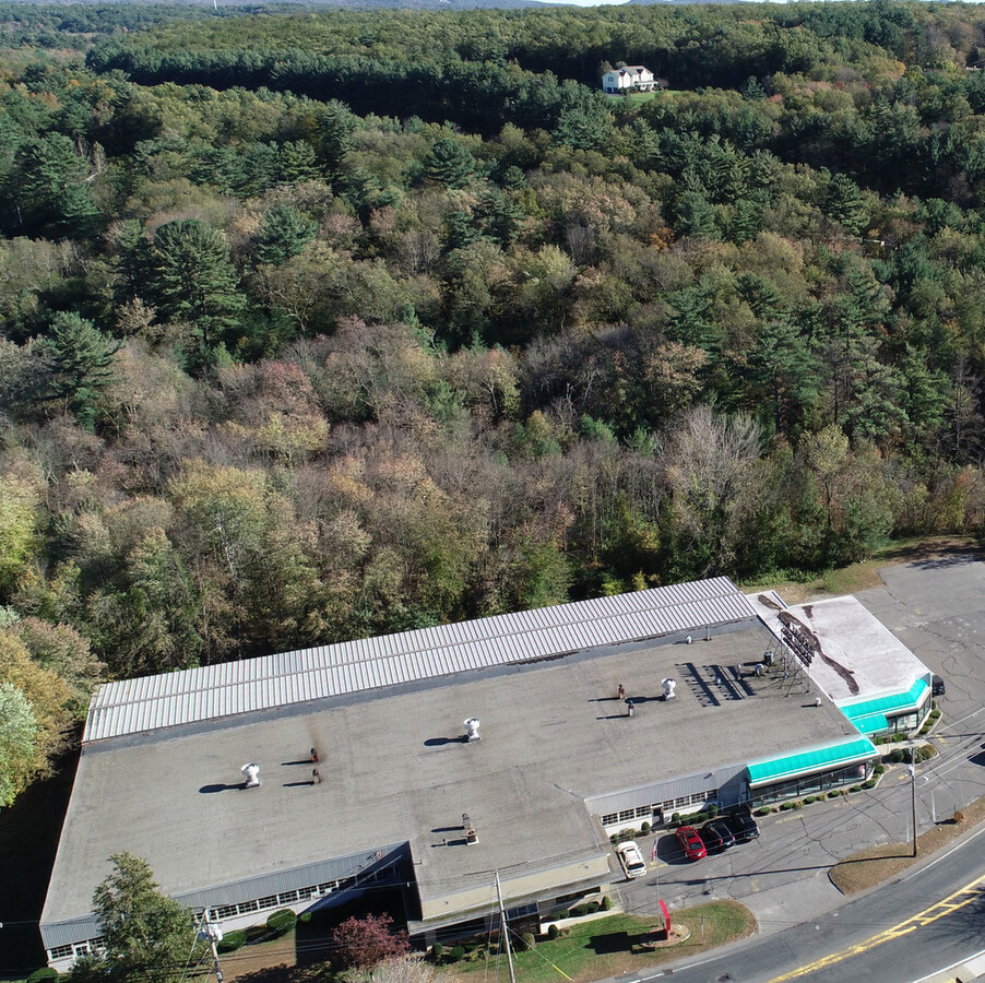
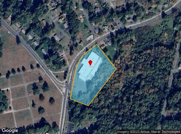
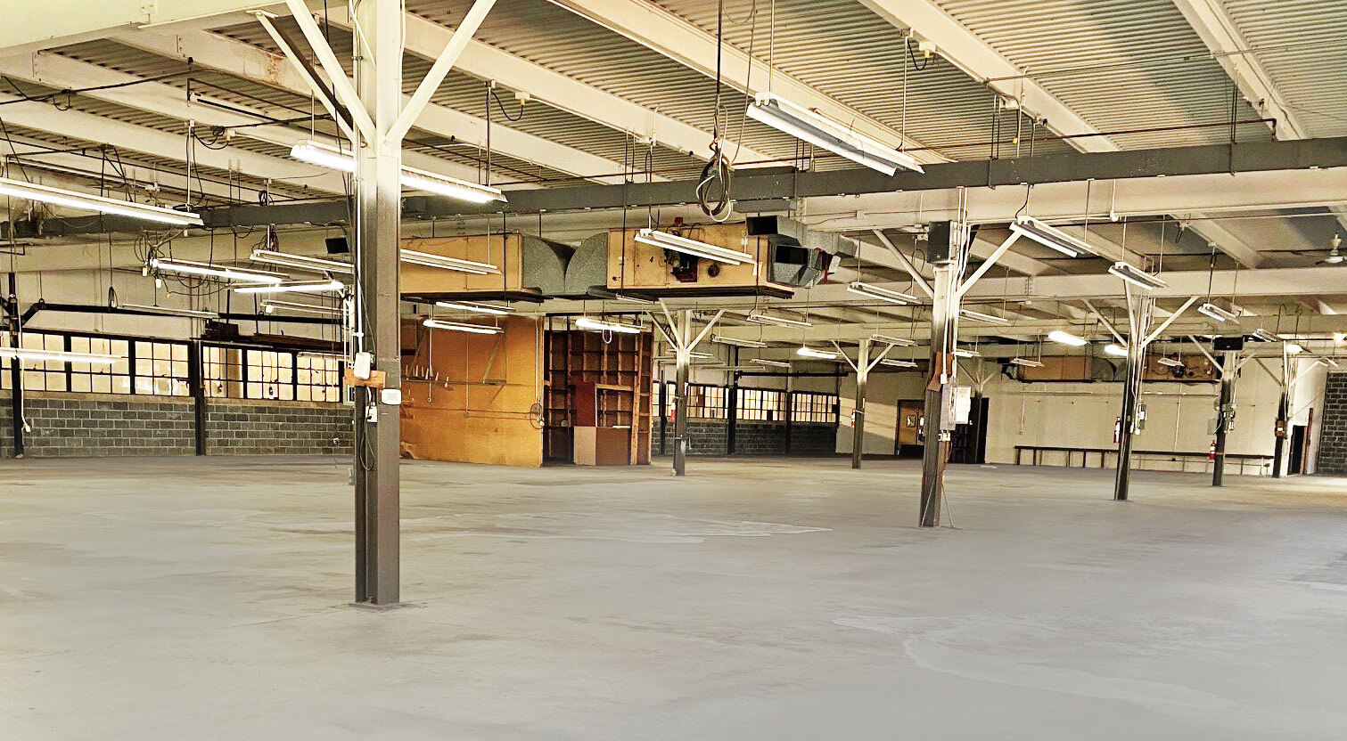
25 Ware St
Manufacturinglight
Hampden
X
Massachusetts
25013C0262E
3.30 AC
2024
Hampden County
2024
Hartford
810200
Springfield, MA
40,964 SF
PALM-000073-000000-000057
DEMOGRAPHICS near 25 Ware St
1 Mile
3 Mile
5 Mile
2024 Total Population
1,247
11,978
21,025
2029 Population
1,202
11,601
19,993
Pop Growth 2024-2029
(3.61%)
(3.15%)
(4.91%)
Average Age
44
43
43
2024 Total Households
549
5,234
8,821
HH Growth 2024-2029
(3.64%)
(3.17%)
(4.94%)
Median Household Inc
$60,234
$67,140
$74,479
Avg Household Size
2.30
2.30
2.40
2024 Avg HH Vehicles
2.00
2.00
2.00
Median Home Value
$248,830
$249,116
$271,519
Median Year Built
1970
1964
1969
Nearby Places
- Restaurants
- Banks
- Shops
- Fitness
- Groceries
PUBLIC TRANSPORTATION
AIRPORT
Bradley International
DRIVE
WALK
Distance
Bradley International
57 min
32.4 mi
Worcester Regional
DRIVE
WALK
Distance
Worcester Regional
53 min
36.8 mi
Freight Ports
Port of Davisville, RI
DRIVE
WALK
Distance
Port of Davisville, RI
111 min
88.1 mi
SALE & LEASE HISTORY
LISTING DATE
SALE/LEASE

Jan 19, 2023
For Sale
Feb 07, 2019
For Lease
Apr 17, 2018
For Sale
Nearby Properties
Address
Land Use
TOTAL SIZE
Lot Size
Zoning
Address
Land Use
TOTAL SIZE
Lot Size
Zoning
8.94 AC
RR
Address
Land Use
TOTAL SIZE
Lot Size
Zoning
137,080 SF
15.72 AC
GB
Address
Land Use
TOTAL SIZE
Lot Size
Zoning
674.33 AC
RR
Address
Land Use
TOTAL SIZE
Lot Size
Zoning
25.40 AC
RR
Address
Land Use
TOTAL SIZE
Lot Size
Zoning
68 AC
TR
Address
Land Use
TOTAL SIZE
Lot Size
Zoning
33.89 AC
RR
Address
Land Use
TOTAL SIZE
Lot Size
Zoning
62,960 SF
1.04 AC
GB
Address
Land Use
TOTAL SIZE
Lot Size
Zoning
2.99 AC
VC2
Address
Land Use
TOTAL SIZE
Lot Size
Zoning
50.20 AC
RR
Address
Land Use
TOTAL SIZE
Lot Size
Zoning
255.28 AC
RR
Address
Land Use
TOTAL SIZE
Lot Size
Zoning
800 SF
Address
Land Use
TOTAL SIZE
Lot Size
Zoning
192,362 SF
5.51 AC
URIP
Address
Land Use
TOTAL SIZE
Lot Size
Zoning
10,080 SF
1.53 AC
VC1
Address
Land Use
TOTAL SIZE
Lot Size
Zoning
912 SF
Address
Land Use
TOTAL SIZE
Lot Size
Zoning
0.92 AC
SR
Address
Land Use
TOTAL SIZE
Lot Size
Zoning
84,748 SF
2 AC
HB
Address
Land Use
TOTAL SIZE
Lot Size
Zoning
9.06 AC
URIP
Address
Land Use
TOTAL SIZE
Lot Size
Zoning
14.73 AC
RR
Address
Land Use
TOTAL SIZE
Lot Size
Zoning
4.69 AC
GB
Address
Land Use
TOTAL SIZE
Lot Size
Zoning
152.05 AC
HB
Address
Land Use
TOTAL SIZE
Lot Size
Zoning
8.96 AC
IA
Address
Land Use
TOTAL SIZE
Lot Size
Zoning
1,012 SF
72.89 AC
RR
Address
Land Use
TOTAL SIZE
Lot Size
Zoning
301 AC
RR
Address
Land Use
TOTAL SIZE
Lot Size
Zoning
53.88 AC
RR
Address
Land Use
TOTAL SIZE
Lot Size
Zoning
1,700 SF
7.91 AC
RC
Address
Land Use
TOTAL SIZE
Lot Size
Zoning
20,518 SF
0.90 AC
TR
Address
Land Use
TOTAL SIZE
Lot Size
Zoning
47,712 SF
3.59 AC
HB
Address
Land Use
TOTAL SIZE
Lot Size
Zoning
48.18 AC
IA
Address
Land Use
TOTAL SIZE
Lot Size
Zoning
10,716 SF
0.31 AC
VC1
Address
Land Use
TOTAL SIZE
Lot Size
Zoning
24,676 SF
1.37 AC
TR
The World's #1 Commercial Real Estate Marketplace
Connect with us
© 2025 CoStar Group
The information above has been obtained from sources believed reliable. While we do not doubt its accuracy we have not verified it and make no guarantee, warranty or representation about it. It is your responsibility to independently confirm its accuracy and completeness. Any projections, opinions, assumptions, or estimates used are for example only and do not represent the current or future performance of the property. The value of this transaction to you depends on tax and other factors which should be evaluated by your tax, financial, and legal advisors. You and your advisors should conduct a careful, independent investigation of the property to determine to your satisfaction the suitability of the property for your needs.