Property Record
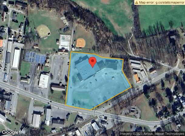
25 Wilson St, Andrews, NC 28901

NEARBY LISTINGS FOR SALE OR LEASE
-
-
View all Andrews listings for sale on LoopNet.com
Property Detail
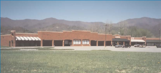
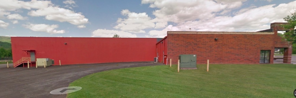
25 Wilson St
Stripcommercialcenter
SHOPPING CENTER TOWN OF ANDREWS 1043/342
X
Cherokee
3700555600J
North Carolina
2023
6.99 AC
2024
North Carolina West/Cherokee Area
930101
Other Market Areas
38,880 SF
5556-16-73-6120-000
DEMOGRAPHICS near 25 Wilson St
1 Mile
3 Mile
5 Mile
2024 Total Population
1,827
3,603
4,556
2029 Population
1,901
3,732
4,712
Pop Growth 2024-2029
+ 4.05%
+ 3.58%
+ 3.42%
Average Age
41
44
44
2024 Total Households
761
1,494
1,888
HH Growth 2024-2029
+ 3.94%
+ 3.35%
+ 3.13%
Median Household Inc
$42,647
$45,024
$44,549
Avg Household Size
2.30
2.30
2.40
2024 Avg HH Vehicles
2.00
2.00
2.00
Median Home Value
$104,027
$133,811
$138,602
Median Year Built
1984
1983
1984
Nearby Places
- Restaurants
- Banks
- Shops
- Fitness
- Groceries
SALE & LEASE HISTORY
LISTING DATE
SALE/LEASE

Sep 25, 2016
For Lease
Sep 24, 2016
For Sale
Jul 17, 2017
For Lease
Feb 03, 2017
For Sale
Dec 07, 2016
For Sale
Aug 02, 2017
For Sale
Nearby Properties
Address
Land Use
TOTAL SIZE
Lot Size
Zoning
Address
Land Use
TOTAL SIZE
Lot Size
Zoning
81.11 AC
Address
Land Use
TOTAL SIZE
Lot Size
Zoning
23,272 SF
6.13 AC
GR
Address
Land Use
TOTAL SIZE
Lot Size
Zoning
42,956 SF
24.16 AC
HC-I
Address
Land Use
TOTAL SIZE
Lot Size
Zoning
24,796 SF
8.06 AC
SF
Address
Land Use
TOTAL SIZE
Lot Size
Zoning
51,383 SF
7.52 AC
SF
Address
Land Use
TOTAL SIZE
Lot Size
Zoning
87,528 SF
20.51 AC
HC-I
Address
Land Use
TOTAL SIZE
Lot Size
Zoning
11,232 SF
11.04 AC
HB
Address
Land Use
TOTAL SIZE
Lot Size
Zoning
10,307 SF
1.38 AC
HB
Address
Land Use
TOTAL SIZE
Lot Size
Zoning
8,646 SF
0.64 AC
CB
Address
Land Use
TOTAL SIZE
Lot Size
Zoning
930.06 AC
Address
Land Use
TOTAL SIZE
Lot Size
Zoning
34,056 SF
8.66 AC
HB
Address
Land Use
TOTAL SIZE
Lot Size
Zoning
6,961 SF
14.23 AC
Address
Land Use
TOTAL SIZE
Lot Size
Zoning
23,348 SF
7.50 AC
GR
Address
Land Use
TOTAL SIZE
Lot Size
Zoning
7,676 SF
4.88 AC
GR
Address
Land Use
TOTAL SIZE
Lot Size
Zoning
90,712 SF
57.85 AC
HC-I
Address
Land Use
TOTAL SIZE
Lot Size
Zoning
22,874 SF
3.05 AC
HB
Address
Land Use
TOTAL SIZE
Lot Size
Zoning
9,600 SF
0.99 AC
CB
Address
Land Use
TOTAL SIZE
Lot Size
Zoning
29.27 AC
Address
Land Use
TOTAL SIZE
Lot Size
Zoning
12,540 SF
18.12 AC
Address
Land Use
TOTAL SIZE
Lot Size
Zoning
12,746 SF
1.43 AC
CB
Address
Land Use
TOTAL SIZE
Lot Size
Zoning
7,676 SF
1.02 AC
HB
Address
Land Use
TOTAL SIZE
Lot Size
Zoning
8,640 SF
11.05 AC
Address
Land Use
TOTAL SIZE
Lot Size
Zoning
5,588 SF
0.69 AC
HB
Address
Land Use
TOTAL SIZE
Lot Size
Zoning
12,000 SF
8.19 AC
HB
Address
Land Use
TOTAL SIZE
Lot Size
Zoning
13,088 SF
1.17 AC
Address
Land Use
TOTAL SIZE
Lot Size
Zoning
3,776 SF
0.63 AC
CB
Address
Land Use
TOTAL SIZE
Lot Size
Zoning
6,476 SF
0.31 AC
CB
Address
Land Use
TOTAL SIZE
Lot Size
Zoning
7,087 SF
1.35 AC
HB
Address
Land Use
TOTAL SIZE
Lot Size
Zoning
3,042 SF
1.59 AC
HB
The World's #1 Commercial Real Estate Marketplace
Connect with us
© 2025 CoStar Group
The information above has been obtained from sources believed reliable. While we do not doubt its accuracy we have not verified it and make no guarantee, warranty or representation about it. It is your responsibility to independently confirm its accuracy and completeness. Any projections, opinions, assumptions, or estimates used are for example only and do not represent the current or future performance of the property. The value of this transaction to you depends on tax and other factors which should be evaluated by your tax, financial, and legal advisors. You and your advisors should conduct a careful, independent investigation of the property to determine to your satisfaction the suitability of the property for your needs.