Property Record
250 Patchogue Yaphank Rd, East Patchogue, NY 11772
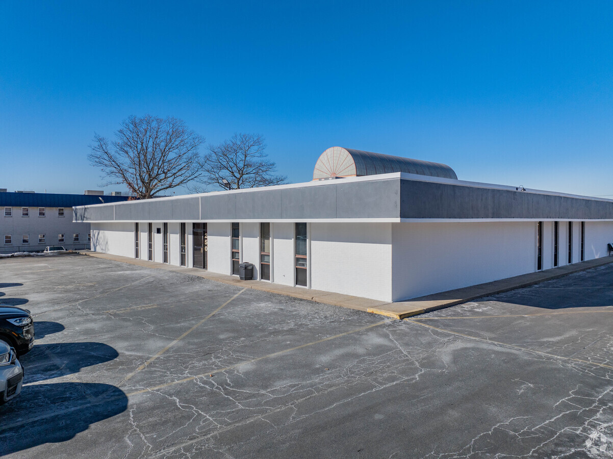
This Property Is For Sale
Current Lease Availabilities
NEARBY LISTINGS FOR SALE OR LEASE
Property Detail
250 Patchogue Yaphank Rd
Nassau County-Suffolk County, NY
Hospital Road Prof Center
0200-975-71-03-00-002-000
HOSPITAL ROAD PROF CENTER 142 STE 1
Commercialbuilding
Suffolk
X
New York
36103C0713H
6
2023
0.03 AC
2023
Central Suffolk
159110
Long Island (New York)
DEMOGRAPHICS near 250 Patchogue Yaphank Rd
1 Mile
3 Mile
5 Mile
2024 Total Population
6,400
66,118
125,101
2029 Population
6,294
65,423
123,933
Pop Growth 2024-2029
(1.66%)
(1.05%)
(0.93%)
Average Age
43
41
42
2024 Total Households
2,492
23,444
44,736
HH Growth 2024-2029
(2.25%)
(1.36%)
(1.14%)
Median Household Inc
$87,254
$100,117
$106,372
Avg Household Size
2.40
2.70
2.70
2024 Avg HH Vehicles
2.00
2.00
2.00
Median Home Value
$421,500
$416,368
$444,957
Median Year Built
1976
1972
1974
Nearby Places
- Restaurants
- Banks
- Shops
- Fitness
- Groceries
PUBLIC TRANSPORTATION
COMMUTER RAIL
Patchogue Station (Montauk Branch - Long Island Rail Road)
DRIVE
WALK
Distance
Patchogue Station (Montauk Branch - Long Island Rail Road)
5 min
2.6 mi
Bellport Station (Montauk Branch - Long Island Rail Road)
DRIVE
WALK
Distance
Bellport Station (Montauk Branch - Long Island Rail Road)
5 min
3.1 mi
AIRPORT
Long Island MacArthur
DRIVE
WALK
Distance
Long Island MacArthur
16 min
8.4 mi
Freight Ports
Port of New Haven
DRIVE
WALK
Distance
Port of New Haven
135 min
52.4 mi
Nearby Properties
Address
Land Use
TOTAL SIZE
Lot Size
Zoning
Address
Land Use
TOTAL SIZE
Lot Size
Zoning
3,278 SF
0.51 AC
VILLA
Address
Land Use
TOTAL SIZE
Lot Size
Zoning
3,942 SF
0.45 AC
VILLA
Address
Land Use
TOTAL SIZE
Lot Size
Zoning
3,960 SF
0.72 AC
R40
Address
Land Use
TOTAL SIZE
Lot Size
Zoning
2,946 SF
1.04 AC
R20
Address
Land Use
TOTAL SIZE
Lot Size
Zoning
28.97 AC
Address
Land Use
TOTAL SIZE
Lot Size
Zoning
1 AC
R40
Address
Land Use
TOTAL SIZE
Lot Size
Zoning
26.20 AC
Address
Land Use
TOTAL SIZE
Lot Size
Zoning
32.04 AC
Address
Land Use
TOTAL SIZE
Lot Size
Zoning
2,880 SF
0.40 AC
VB
Address
Land Use
TOTAL SIZE
Lot Size
Zoning
8.30 AC
Address
Land Use
TOTAL SIZE
Lot Size
Zoning
0.80 AC
CR80
Address
Land Use
TOTAL SIZE
Lot Size
Zoning
19.01 AC
Address
Land Use
TOTAL SIZE
Lot Size
Zoning
0.98 AC
CR80
Address
Land Use
TOTAL SIZE
Lot Size
Zoning
Address
Land Use
TOTAL SIZE
Lot Size
Zoning
2,444 SF
0.17 AC
VILLA
Address
Land Use
TOTAL SIZE
Lot Size
Zoning
32.52 AC
Address
Land Use
TOTAL SIZE
Lot Size
Zoning
0.02 AC
R40
Address
Land Use
TOTAL SIZE
Lot Size
Zoning
Address
Land Use
TOTAL SIZE
Lot Size
Zoning
1,828 SF
0.18 AC
VILLA
Address
Land Use
TOTAL SIZE
Lot Size
Zoning
5.62 AC
Address
Land Use
TOTAL SIZE
Lot Size
Zoning
0.99 AC
Address
Land Use
TOTAL SIZE
Lot Size
Zoning
21.19 AC
Address
Land Use
TOTAL SIZE
Lot Size
Zoning
Address
Land Use
TOTAL SIZE
Lot Size
Zoning
Address
Land Use
TOTAL SIZE
Lot Size
Zoning
12.09 AC
Address
Land Use
TOTAL SIZE
Lot Size
Zoning
8.34 AC
Address
Land Use
TOTAL SIZE
Lot Size
Zoning
9.25 AC
Address
Land Use
TOTAL SIZE
Lot Size
Zoning
37.51 AC
Address
Land Use
TOTAL SIZE
Lot Size
Zoning
65.86 AC
Address
Land Use
TOTAL SIZE
Lot Size
Zoning
The World's #1 Commercial Real Estate Marketplace
Connect with us
© 2025 CoStar Group
The information above has been obtained from sources believed reliable. While we do not doubt its accuracy we have not verified it and make no guarantee, warranty or representation about it. It is your responsibility to independently confirm its accuracy and completeness. Any projections, opinions, assumptions, or estimates used are for example only and do not represent the current or future performance of the property. The value of this transaction to you depends on tax and other factors which should be evaluated by your tax, financial, and legal advisors. You and your advisors should conduct a careful, independent investigation of the property to determine to your satisfaction the suitability of the property for your needs.