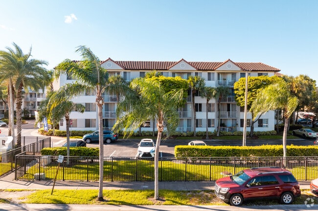
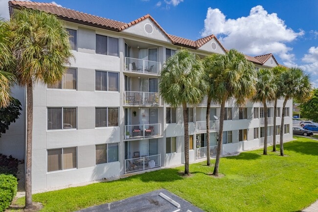
Property Record
2500 W 56Th St, Hialeah, FL 33016

Property Detail
2500 W 56Th St
04-2034-160-0010
VILLA HIALEAH SUB PB 133-11 TRACT A LOT SIZZE 9.726 AC M/L OR 20900-3881 1202 6 COC 22581-4303 08 2004 5
Multifamilydwelling
Miami-Dade
4600
Florida
B and X Area of moderate flood hazard, usually the area between the limits of the 100-year and 500-year floods.
9.73 AC
2024
Hialeah
2025
South Florida
013802
Miami-Miami Beach-Kendall, FL
293,854 SF
NEARBY LISTINGS FOR SALE OR LEASE
DEMOGRAPHICS near 2500 W 56Th St
1 mile
3 mile
5 mile
2025 Total Population
46,210
196,063
415,317
2030 Population
48,993
209,204
443,666
Pop Growth 2025-2030
+ 6.02%
+ 6.70%
+ 6.83%
Average Age
43
43
42
2025 Total Households
15,600
64,936
138,247
HH Growth 2025-2030
+ 5.91%
+ 6.63%
+ 6.77%
Median Household Inc
$51,717
$62,100
$70,255
Avg Household Size
2.90
2.90
2.90
2025 Avg HH Vehicles
2.00
2.00
2.00
Median Home Value
$292,537
$416,580
$457,282
Median Year Built
1984
1982
1984
Nearby Places
Map Layers
Map Styles
 Street
 Aerial
Layers
 Traffic
 Biking
Places
Listings with unknown addresses are not visible on the map
- Restaurants
- Banks
- Shops
- Fitness
- Groceries
PUBLIC TRANSPORTATION
COMMUTER RAIL
Palmetto (Metrorail Green Line - Miami-Dade Transit (Metrorail/Metromover))
Drive
Walk
Distance
Palmetto (Metrorail Green Line - Miami-Dade Transit (Metrorail/Metromover))
7 min
3.2 mi
Okeechobee (Metrorail Green Line - Miami-Dade Transit (Metrorail/Metromover))
Drive
Walk
Distance
Okeechobee (Metrorail Green Line - Miami-Dade Transit (Metrorail/Metromover))
9 min
3.9 mi
AIRPORT
Miami International
Drive
Walk
Distance
Miami International
18 min
8.3 mi
Fort Lauderdale/Hollywood International
Drive
Walk
Distance
Fort Lauderdale/Hollywood International
37 min
24.3 mi
Freight Ports
Port of Miami
Drive
Walk
Distance
Port of Miami
31 min
17.8 mi
Nearby Properties
Address
Land Use
TOTAL SIZE
Lot Size
Zoning
Address
Land Use
TOTAL SIZE
Lot Size
Zoning
312,996 SF
157.16 AC
8900
Address
Land Use
TOTAL SIZE
Lot Size
Zoning
614,708 SF
22.54 AC
4400
Address
Land Use
TOTAL SIZE
Lot Size
Zoning
636,721 SF
52.61 AC
2800
Address
Land Use
TOTAL SIZE
Lot Size
Zoning
777,714 SF
7.59 AC
9450
Address
Land Use
TOTAL SIZE
Lot Size
Zoning
439,520 SF
20.20 AC
9400
Address
Land Use
TOTAL SIZE
Lot Size
Zoning
595,768 SF
33.42 AC
7600
Address
Land Use
TOTAL SIZE
Lot Size
Zoning
725,624 SF
34.80 AC
7300
Address
Land Use
TOTAL SIZE
Lot Size
Zoning
526,059 SF
18.99 AC
6407
Address
Land Use
TOTAL SIZE
Lot Size
Zoning
687,804 SF
3.84 AC
9450
Address
Land Use
TOTAL SIZE
Lot Size
Zoning
301,593 SF
16 AC
7100
Address
Land Use
TOTAL SIZE
Lot Size
Zoning
538,715 SF
24.72 AC
7100
Address
Land Use
TOTAL SIZE
Lot Size
Zoning
322,084 SF
6.60 AC
7100
Address
Land Use
TOTAL SIZE
Lot Size
Zoning
344,465 SF
5.03 AC
6400
Address
Land Use
TOTAL SIZE
Lot Size
Zoning
533,605 SF
10.86 AC
9450
Address
Land Use
TOTAL SIZE
Lot Size
Zoning
648,867 SF
33.08 AC
7100
Address
Land Use
TOTAL SIZE
Lot Size
Zoning
255,793 SF
17.14 AC
8000
Address
Land Use
TOTAL SIZE
Lot Size
Zoning
359,483 SF
11.34 AC
8000
Address
Land Use
TOTAL SIZE
Lot Size
Zoning
223,543 SF
39.40 AC
6407
Address
Land Use
TOTAL SIZE
Lot Size
Zoning
382,421 SF
19.66 AC
3700
Address
Land Use
TOTAL SIZE
Lot Size
Zoning
400,062 SF
33.33 AC
0101
Address
Land Use
TOTAL SIZE
Lot Size
Zoning
225,137 SF
80.89 AC
7600
Address
Land Use
TOTAL SIZE
Lot Size
Zoning
419,656 SF
8.61 AC
6400
Address
Land Use
TOTAL SIZE
Lot Size
Zoning
445,429 SF
4.45 AC
6400
Address
Land Use
TOTAL SIZE
Lot Size
Zoning
177,893 SF
15.02 AC
7100
Address
Land Use
TOTAL SIZE
Lot Size
Zoning
313,129 SF
16.06 AC
7100
Address
Land Use
TOTAL SIZE
Lot Size
Zoning
252,698 SF
13.22 AC
7100
Address
Land Use
TOTAL SIZE
Lot Size
Zoning
293,962 SF
9.99 AC
4400
Address
Land Use
TOTAL SIZE
Lot Size
Zoning
249,486 SF
11.84 AC
7100
Address
Land Use
TOTAL SIZE
Lot Size
Zoning
196,118 SF
11.06 AC
7100
Address
Land Use
TOTAL SIZE
Lot Size
Zoning
308,699 SF
28.97 AC
7100
The World's #1 Commercial Real Estate Marketplace
Connect with us
© 2026 CoStar Group
The information above has been obtained from sources believed reliable. While we do not doubt its accuracy we have not verified it and make no guarantee, warranty or representation about it. It is your responsibility to independently confirm its accuracy and completeness. Any projections, opinions, assumptions, or estimates used are for example only and do not represent the current or future performance of the property. The value of this transaction to you depends on tax and other factors which should be evaluated by your tax, financial, and legal advisors. You and your advisors should conduct a careful, independent investigation of the property to determine to your satisfaction the suitability of the property for your needs.