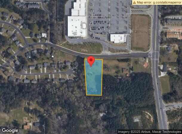
Property Record
2500 Woodward Rd, Atlanta, GA 30349
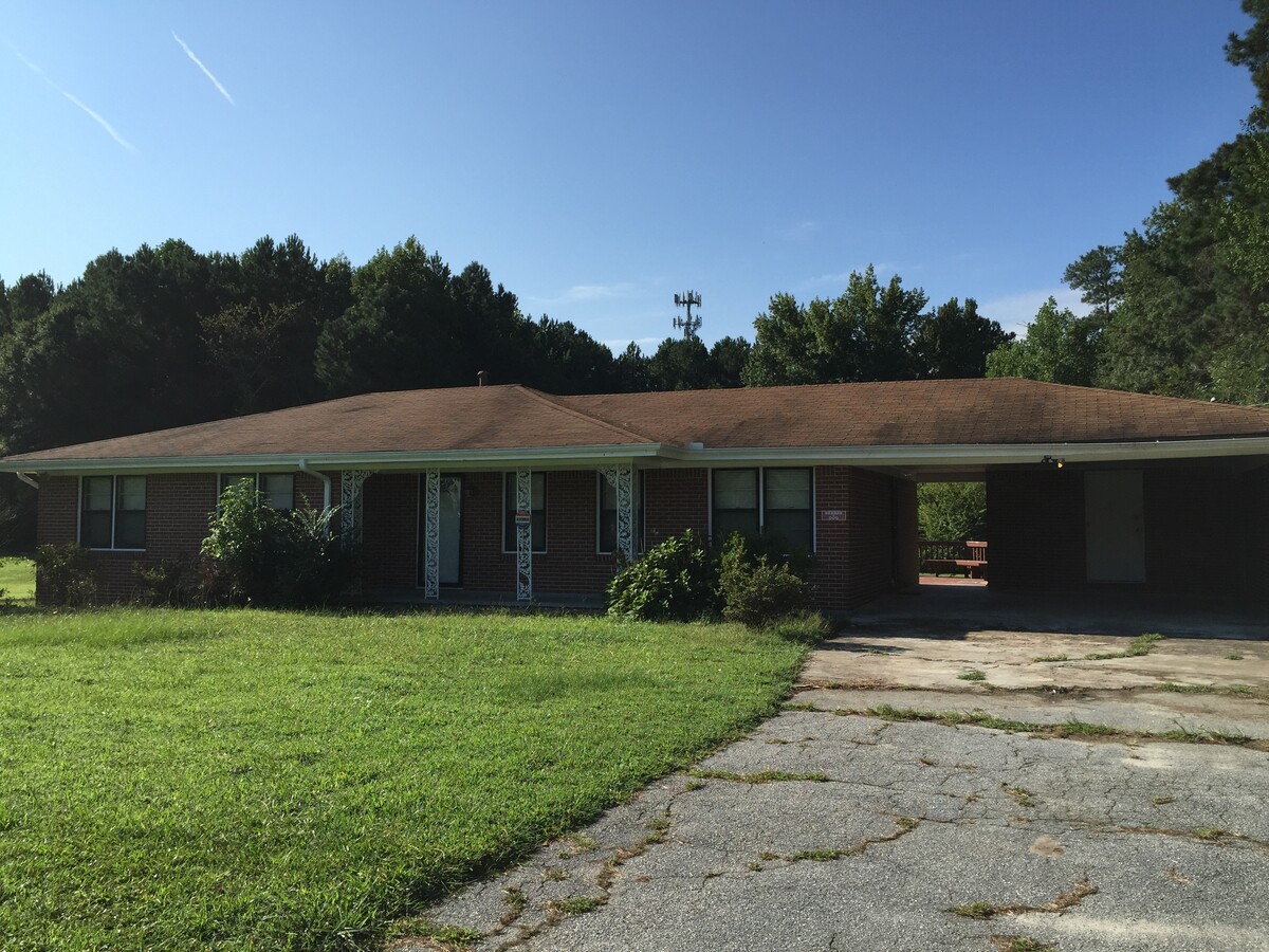
This Property Is For Sale
NEARBY LISTINGS FOR SALE OR LEASE
Property Detail
2500 Woodward Rd
Atlanta-Sandy Springs-Roswell, GA
Bobby R Lee
13-0132-LL-079-9
Fulton
Sfr
Georgia
X
1.70 AC
13121C0478F
North Clayton/Airport
1,392 SF
Atlanta
DEMOGRAPHICS near 2500 Woodward Rd
1 Mile
3 Mile
5 Mile
2024 Total Population
9,693
69,550
151,189
2029 Population
10,026
71,048
154,448
Pop Growth 2024-2029
+ 3.44%
+ 2.15%
+ 2.16%
Average Age
38
37
37
2024 Total Households
3,440
25,725
57,368
HH Growth 2024-2029
+ 3.60%
+ 2.11%
+ 2.13%
Median Household Inc
$71,140
$55,064
$50,679
Avg Household Size
2.80
2.60
2.60
2024 Avg HH Vehicles
2.00
2.00
2.00
Median Home Value
$191,521
$169,352
$171,577
Median Year Built
1995
1987
1986
Nearby Places
- Restaurants
- Banks
- Shops
- Fitness
- Groceries
PUBLIC TRANSPORTATION
AIRPORT
Hartsfield - Jackson Atlanta International
DRIVE
WALK
Distance
Hartsfield - Jackson Atlanta International
16 min
8.9 mi
Freight Ports
Georgia Ports - Savannah
DRIVE
WALK
Distance
Georgia Ports - Savannah
277 min
243.8 mi
Nearby Properties
Address
Land Use
TOTAL SIZE
Lot Size
Zoning
Address
Land Use
TOTAL SIZE
Lot Size
Zoning
699 SF
44.34 AC
RM
Address
Land Use
TOTAL SIZE
Lot Size
Zoning
240 SF
26.94 AC
RM
Address
Land Use
TOTAL SIZE
Lot Size
Zoning
992,870 SF
59.71 AC
M1
Address
Land Use
TOTAL SIZE
Lot Size
Zoning
388,225 SF
32.55 AC
A
Address
Land Use
TOTAL SIZE
Lot Size
Zoning
160,662 SF
3.58 AC
M1
Address
Land Use
TOTAL SIZE
Lot Size
Zoning
216 SF
24.45 AC
RM
Address
Land Use
TOTAL SIZE
Lot Size
Zoning
1,026,040 SF
72.52 AC
M1
Address
Land Use
TOTAL SIZE
Lot Size
Zoning
296 SF
27.93 AC
RM
Address
Land Use
TOTAL SIZE
Lot Size
Zoning
358,011 SF
60.44 AC
AG1
Address
Land Use
TOTAL SIZE
Lot Size
Zoning
370 SF
36.20 AC
RM
Address
Land Use
TOTAL SIZE
Lot Size
Zoning
262,427 SF
18.79 AC
MF
Address
Land Use
TOTAL SIZE
Lot Size
Zoning
278,904 SF
30.58 AC
RM
Address
Land Use
TOTAL SIZE
Lot Size
Zoning
177 SF
23.79 AC
RM
Address
Land Use
TOTAL SIZE
Lot Size
Zoning
9.04 AC
C
Address
Land Use
TOTAL SIZE
Lot Size
Zoning
257,723 SF
28.76 AC
C1
Address
Land Use
TOTAL SIZE
Lot Size
Zoning
234,763 SF
22.43 AC
OI
Address
Land Use
TOTAL SIZE
Lot Size
Zoning
365,092 SF
26.70 AC
AG1
Address
Land Use
TOTAL SIZE
Lot Size
Zoning
147,540 SF
47.10 AC
C RP
Address
Land Use
TOTAL SIZE
Lot Size
Zoning
178,002 SF
39.88 AC
OI
Address
Land Use
TOTAL SIZE
Lot Size
Zoning
230,068 SF
22.64 AC
M1
Address
Land Use
TOTAL SIZE
Lot Size
Zoning
369,000 SF
43.81 AC
AC
Address
Land Use
TOTAL SIZE
Lot Size
Zoning
212 SF
20.18 AC
RM
Address
Land Use
TOTAL SIZE
Lot Size
Zoning
141 SF
12.89 AC
RM
Address
Land Use
TOTAL SIZE
Lot Size
Zoning
182 SF
13.68 AC
C
Address
Land Use
TOTAL SIZE
Lot Size
Zoning
93,568 SF
15.84 AC
R4C
Address
Land Use
TOTAL SIZE
Lot Size
Zoning
132,252 SF
14.33 AC
C1C
Address
Land Use
TOTAL SIZE
Lot Size
Zoning
1,440 SF
7.37 AC
C
Address
Land Use
TOTAL SIZE
Lot Size
Zoning
312,240 SF
38.93 AC
MIA
Address
Land Use
TOTAL SIZE
Lot Size
Zoning
175,539 SF
14.47 AC
RM
Address
Land Use
TOTAL SIZE
Lot Size
Zoning
157,960 SF
16.24 AC
RM
The World's #1 Commercial Real Estate Marketplace
Connect with us
© 2025 CoStar Group
The information above has been obtained from sources believed reliable. While we do not doubt its accuracy we have not verified it and make no guarantee, warranty or representation about it. It is your responsibility to independently confirm its accuracy and completeness. Any projections, opinions, assumptions, or estimates used are for example only and do not represent the current or future performance of the property. The value of this transaction to you depends on tax and other factors which should be evaluated by your tax, financial, and legal advisors. You and your advisors should conduct a careful, independent investigation of the property to determine to your satisfaction the suitability of the property for your needs.