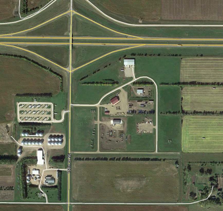
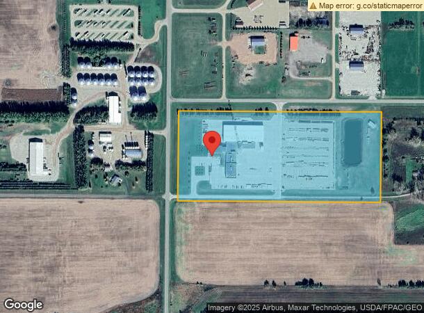
Property Record
2501 158Th St Ne, Menoken, ND 58558
NEARBY LISTINGS FOR SALE OR LEASE
-
-
View all Menoken listings for sale on LoopNet.com
Property Detail
2501 158Th St Ne
Bismarck, ND
TWN: 139 SCT: 28 RNG: 78 SUB: 331397860 BLK: 01 LOT: 1 YVONNE'S INDUSTRIAL PARK BLOCK 01 LOT 1 (FORMERLY LOTS 1-3)
33-139-78-60-01-010
Burleigh
Realpropertynec
North Dakota
X
1-3
38015C0835D
8.33 AC
2023
Bismarck
2023
Other Market Areas
011400
DEMOGRAPHICS near 2501 158Th St Ne
1 Mile
3 Mile
5 Mile
2024 Total Population
45
322
968
2029 Population
46
331
994
Pop Growth 2024-2029
+ 2.22%
+ 2.80%
+ 2.69%
Average Age
43
42
42
2024 Total Households
16
118
354
HH Growth 2024-2029
+ 6.25%
+ 2.54%
+ 2.54%
Median Household Inc
$112,500
$102,678
$103,529
Avg Household Size
2.60
2.80
2.70
2024 Avg HH Vehicles
3.00
3.00
3.00
Median Home Value
$350,000
$345,652
$346,478
Median Year Built
1997
1994
1994
Nearby Places
- Restaurants
- Banks
- Shops
- Fitness
- Groceries
PUBLIC TRANSPORTATION
AIRPORT
Bismarck Municipal
DRIVE
WALK
Distance
Bismarck Municipal
26 min
14.7 mi
Freight Ports
Port Milwaukee
DRIVE
WALK
Distance
Port Milwaukee
809 min
752.5 mi
Nearby Properties
Address
Land Use
TOTAL SIZE
Lot Size
Zoning
Address
Land Use
TOTAL SIZE
Lot Size
Zoning
1,400 SF
53.45 AC
Address
Land Use
TOTAL SIZE
Lot Size
Zoning
11,300 SF
2.42 AC
Address
Land Use
TOTAL SIZE
Lot Size
Zoning
5,000 SF
2.18 AC
Address
Land Use
TOTAL SIZE
Lot Size
Zoning
575 SF
2.46 AC
Address
Land Use
TOTAL SIZE
Lot Size
Zoning
18,000 SF
4.31 AC
Address
Land Use
TOTAL SIZE
Lot Size
Zoning
1,538 SF
1.50 AC
Address
Land Use
TOTAL SIZE
Lot Size
Zoning
5,200 SF
2.01 AC
Address
Land Use
TOTAL SIZE
Lot Size
Zoning
3,804 SF
2.38 AC
Address
Land Use
TOTAL SIZE
Lot Size
Zoning
5,200 SF
2.01 AC
Address
Land Use
TOTAL SIZE
Lot Size
Zoning
38.25 AC
Address
Land Use
TOTAL SIZE
Lot Size
Zoning
3.15 AC
Address
Land Use
TOTAL SIZE
Lot Size
Zoning
Address
Land Use
TOTAL SIZE
Lot Size
Zoning
3.12 AC
Address
Land Use
TOTAL SIZE
Lot Size
Zoning
3.02 AC
Address
Land Use
TOTAL SIZE
Lot Size
Zoning
Address
Land Use
TOTAL SIZE
Lot Size
Zoning
Address
Land Use
TOTAL SIZE
Lot Size
Zoning
Address
Land Use
TOTAL SIZE
Lot Size
Zoning
152.12 AC
Address
Land Use
TOTAL SIZE
Lot Size
Zoning
Address
Land Use
TOTAL SIZE
Lot Size
Zoning
Address
Land Use
TOTAL SIZE
Lot Size
Zoning
2.18 AC
Address
Land Use
TOTAL SIZE
Lot Size
Zoning
2.18 AC
Address
Land Use
TOTAL SIZE
Lot Size
Zoning
2.13 AC
Address
Land Use
TOTAL SIZE
Lot Size
Zoning
2.02 AC
Address
Land Use
TOTAL SIZE
Lot Size
Zoning
5,000 SF
2.03 AC
Address
Land Use
TOTAL SIZE
Lot Size
Zoning
157.46 AC
Address
Land Use
TOTAL SIZE
Lot Size
Zoning
2.02 AC
Address
Land Use
TOTAL SIZE
Lot Size
Zoning
2.02 AC
Address
Land Use
TOTAL SIZE
Lot Size
Zoning
The World's #1 Commercial Real Estate Marketplace
Connect with us
© 2025 CoStar Group
The information above has been obtained from sources believed reliable. While we do not doubt its accuracy we have not verified it and make no guarantee, warranty or representation about it. It is your responsibility to independently confirm its accuracy and completeness. Any projections, opinions, assumptions, or estimates used are for example only and do not represent the current or future performance of the property. The value of this transaction to you depends on tax and other factors which should be evaluated by your tax, financial, and legal advisors. You and your advisors should conduct a careful, independent investigation of the property to determine to your satisfaction the suitability of the property for your needs.