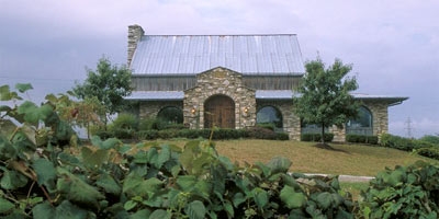
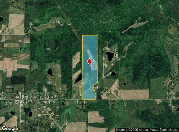
Property Record
25043 Jacobs Rd, Guilford, IN 47022

Current Lease Availabilities
NEARBY LISTINGS FOR SALE OR LEASE
-
-
View all Guilford listings for lease on LoopNet.com
Property Detail
25043 Jacobs Rd
15-02-28-400-016.000-010
17-08 PT W1/2 E1/2 SE 28-7-2 36.82A
Commercialnec
Dearborn
X
Indiana
18029C0105C
36.82 AC
2023
Dearborn County
2023
Cincinnati/Dayton
080201
Cincinnati, OH-KY-IN
8,364 SF
DEMOGRAPHICS near 25043 Jacobs Rd
1 Mile
3 Mile
5 Mile
2024 Total Population
310
2,339
6,657
2029 Population
315
2,364
6,757
Pop Growth 2024-2029
+ 1.61%
+ 1.07%
+ 1.50%
Average Age
42
42
42
2024 Total Households
114
862
2,423
HH Growth 2024-2029
+ 1.75%
+ 1.04%
+ 1.36%
Median Household Inc
$124,166
$110,613
$100,080
Avg Household Size
2.60
2.70
2.70
2024 Avg HH Vehicles
3.00
3.00
3.00
Median Home Value
$255,882
$264,195
$274,061
Median Year Built
1987
1989
1990
Nearby Places
- Restaurants
- Banks
- Shops
- Fitness
- Groceries
PUBLIC TRANSPORTATION
AIRPORT
Cincinnati/Northern Kentucky International
DRIVE
WALK
Distance
Cincinnati/Northern Kentucky International
55 min
31.1 mi
Freight Ports
Port of Toledo
DRIVE
WALK
Distance
Port of Toledo
269 min
228.2 mi
Nearby Properties
Address
Land Use
TOTAL SIZE
Lot Size
Zoning
Address
Land Use
TOTAL SIZE
Lot Size
Zoning
7,500 SF
9.29 AC
Address
Land Use
TOTAL SIZE
Lot Size
Zoning
5,146 SF
26.39 AC
Address
Land Use
TOTAL SIZE
Lot Size
Zoning
11,950 SF
3.07 AC
Address
Land Use
TOTAL SIZE
Lot Size
Zoning
Address
Land Use
TOTAL SIZE
Lot Size
Zoning
5,041 SF
2.04 AC
Address
Land Use
TOTAL SIZE
Lot Size
Zoning
3,192 SF
3 AC
Address
Land Use
TOTAL SIZE
Lot Size
Zoning
6,714 SF
4.23 AC
Address
Land Use
TOTAL SIZE
Lot Size
Zoning
1,620 SF
78.16 AC
Address
Land Use
TOTAL SIZE
Lot Size
Zoning
94.85 AC
Address
Land Use
TOTAL SIZE
Lot Size
Zoning
4,132 SF
1.32 AC
Address
Land Use
TOTAL SIZE
Lot Size
Zoning
6,272 SF
3.91 AC
Address
Land Use
TOTAL SIZE
Lot Size
Zoning
3,360 SF
1.12 AC
Address
Land Use
TOTAL SIZE
Lot Size
Zoning
145.89 AC
Address
Land Use
TOTAL SIZE
Lot Size
Zoning
80 AC
Address
Land Use
TOTAL SIZE
Lot Size
Zoning
1.59 AC
Address
Land Use
TOTAL SIZE
Lot Size
Zoning
3,988 SF
0.51 AC
Address
Land Use
TOTAL SIZE
Lot Size
Zoning
1,576 SF
160 AC
Address
Land Use
TOTAL SIZE
Lot Size
Zoning
24.41 AC
Address
Land Use
TOTAL SIZE
Lot Size
Zoning
595 SF
74.49 AC
Address
Land Use
TOTAL SIZE
Lot Size
Zoning
78.53 AC
Address
Land Use
TOTAL SIZE
Lot Size
Zoning
1,992 SF
55.28 AC
Address
Land Use
TOTAL SIZE
Lot Size
Zoning
103.03 AC
Address
Land Use
TOTAL SIZE
Lot Size
Zoning
21.60 AC
Address
Land Use
TOTAL SIZE
Lot Size
Zoning
Address
Land Use
TOTAL SIZE
Lot Size
Zoning
Address
Land Use
TOTAL SIZE
Lot Size
Zoning
48.02 AC
Address
Land Use
TOTAL SIZE
Lot Size
Zoning
2 AC
Address
Land Use
TOTAL SIZE
Lot Size
Zoning
1.40 AC
Address
Land Use
TOTAL SIZE
Lot Size
Zoning
3,432 SF
0.68 AC
The World's #1 Commercial Real Estate Marketplace
Connect with us
© 2025 CoStar Group
The information above has been obtained from sources believed reliable. While we do not doubt its accuracy we have not verified it and make no guarantee, warranty or representation about it. It is your responsibility to independently confirm its accuracy and completeness. Any projections, opinions, assumptions, or estimates used are for example only and do not represent the current or future performance of the property. The value of this transaction to you depends on tax and other factors which should be evaluated by your tax, financial, and legal advisors. You and your advisors should conduct a careful, independent investigation of the property to determine to your satisfaction the suitability of the property for your needs.