Property Record
25101 Ford Rd, Dearborn, MI 48128

NEARBY LISTINGS FOR SALE OR LEASE
Property Detail
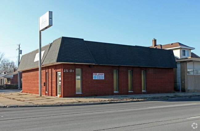
25101 Ford Rd
32-09-171-27-017
Survey For Emil Cunov
Medicalbuilding
LAND IN SEC 17 T2SR10E BEG AT A PT ON SL OF FORD RD PT BEINGS-89-44-00-E ALG NL OF SEC 17,963.105 FT & S-00-11-00-E 53 FT FROM INT OF NL OF SEC 17 & WL OF E 1/2 OF NW 1/4 OF SEC 17, TH S-00-00-50-W 133.71 FT,TH N-89-44-00-W 55.555 FT, TH N-00-11-00-W
X
Wayne
26163C0233E
Michigan
2025
0.17 AC
2025
Dearborn
574700
Detroit
2,116 SF
Detroit-Warren-Dearborn, MI
DEMOGRAPHICS near 25101 Ford Rd
1 Mile
3 Mile
5 Mile
2024 Total Population
17,101
125,581
317,099
2029 Population
16,377
121,104
306,639
Pop Growth 2024-2029
(4.23%)
(3.57%)
(3.30%)
Average Age
38
39
38
2024 Total Households
5,777
47,694
121,473
HH Growth 2024-2029
(4.29%)
(3.56%)
(3.37%)
Median Household Inc
$78,066
$62,948
$57,031
Avg Household Size
2.90
2.60
2.50
2024 Avg HH Vehicles
2.00
2.00
2.00
Median Home Value
$207,048
$171,646
$149,253
Median Year Built
1957
1956
1955
Nearby Places
Map Layers
Map Styles
 Street
 Aerial
- Restaurants
- Banks
- Shops
- Fitness
- Groceries
PUBLIC TRANSPORTATION
COMMUTER RAIL
DRIVE
WALK
Distance
10 min
3.7 mi
AIRPORT
Detroit Metro Wayne County
DRIVE
WALK
Distance
Detroit Metro Wayne County
24 min
12.9 mi
Windsor International
DRIVE
WALK
Distance
Windsor International
45 min
23.4 mi
Freight Ports
DRIVE
WALK
Distance
76 min
56.2 mi
Nearby Properties
Address
Land Use
TOTAL SIZE
Lot Size
Zoning
Address
Land Use
TOTAL SIZE
Lot Size
Zoning
5,597,761 SF
73.85 AC
IB
Address
Land Use
TOTAL SIZE
Lot Size
Zoning
324,414 SF
18.68 AC
RD
Address
Land Use
TOTAL SIZE
Lot Size
Zoning
Address
Land Use
TOTAL SIZE
Lot Size
Zoning
335,133 SF
22.08 AC
Address
Land Use
TOTAL SIZE
Lot Size
Zoning
126,712 SF
4.52 AC
BC
Address
Land Use
TOTAL SIZE
Lot Size
Zoning
463,642 SF
22.82 AC
Address
Land Use
TOTAL SIZE
Lot Size
Zoning
247,588 SF
4.12 AC
RE
Address
Land Use
TOTAL SIZE
Lot Size
Zoning
240,425 SF
6.39 AC
IB
Address
Land Use
TOTAL SIZE
Lot Size
Zoning
328,480 SF
11.54 AC
IA
Address
Land Use
TOTAL SIZE
Lot Size
Zoning
84,333 SF
1.15 AC
BC
Address
Land Use
TOTAL SIZE
Lot Size
Zoning
63,898 SF
BC
Address
Land Use
TOTAL SIZE
Lot Size
Zoning
107,680 SF
7.46 AC
BC
Address
Land Use
TOTAL SIZE
Lot Size
Zoning
63,706 SF
0.96 AC
BC
Address
Land Use
TOTAL SIZE
Lot Size
Zoning
179,412 SF
2.17 AC
Address
Land Use
TOTAL SIZE
Lot Size
Zoning
149,735 SF
6.64 AC
Address
Land Use
TOTAL SIZE
Lot Size
Zoning
Address
Land Use
TOTAL SIZE
Lot Size
Zoning
152,424 SF
5.02 AC
Address
Land Use
TOTAL SIZE
Lot Size
Zoning
58,958 SF
2.15 AC
BC
Address
Land Use
TOTAL SIZE
Lot Size
Zoning
127,017 SF
6.91 AC
Address
Land Use
TOTAL SIZE
Lot Size
Zoning
94,353 SF
8.70 AC
BC
Address
Land Use
TOTAL SIZE
Lot Size
Zoning
57,345 SF
0.73 AC
BC
Address
Land Use
TOTAL SIZE
Lot Size
Zoning
176,883 SF
10.83 AC
Address
Land Use
TOTAL SIZE
Lot Size
Zoning
110,117 SF
5.85 AC
RE
Address
Land Use
TOTAL SIZE
Lot Size
Zoning
114,337 SF
3.94 AC
RE
Address
Land Use
TOTAL SIZE
Lot Size
Zoning
88,769 SF
0.91 AC
IB
Address
Land Use
TOTAL SIZE
Lot Size
Zoning
138,447 SF
11.40 AC
BC
Address
Land Use
TOTAL SIZE
Lot Size
Zoning
171,414 SF
23.57 AC
Address
Land Use
TOTAL SIZE
Lot Size
Zoning
240,100 SF
4.09 AC
OS
Address
Land Use
TOTAL SIZE
Lot Size
Zoning
61,031 SF
5.14 AC
BC
Address
Land Use
TOTAL SIZE
Lot Size
Zoning
47,900 SF
2.34 AC
BC
The World's #1 Commercial Real Estate Marketplace
Connect with us
© 2025 CoStar Group
The information above has been obtained from sources believed reliable. While we do not doubt its accuracy we have not verified it and make no guarantee, warranty or representation about it. It is your responsibility to independently confirm its accuracy and completeness. Any projections, opinions, assumptions, or estimates used are for example only and do not represent the current or future performance of the property. The value of this transaction to you depends on tax and other factors which should be evaluated by your tax, financial, and legal advisors. You and your advisors should conduct a careful, independent investigation of the property to determine to your satisfaction the suitability of the property for your needs.