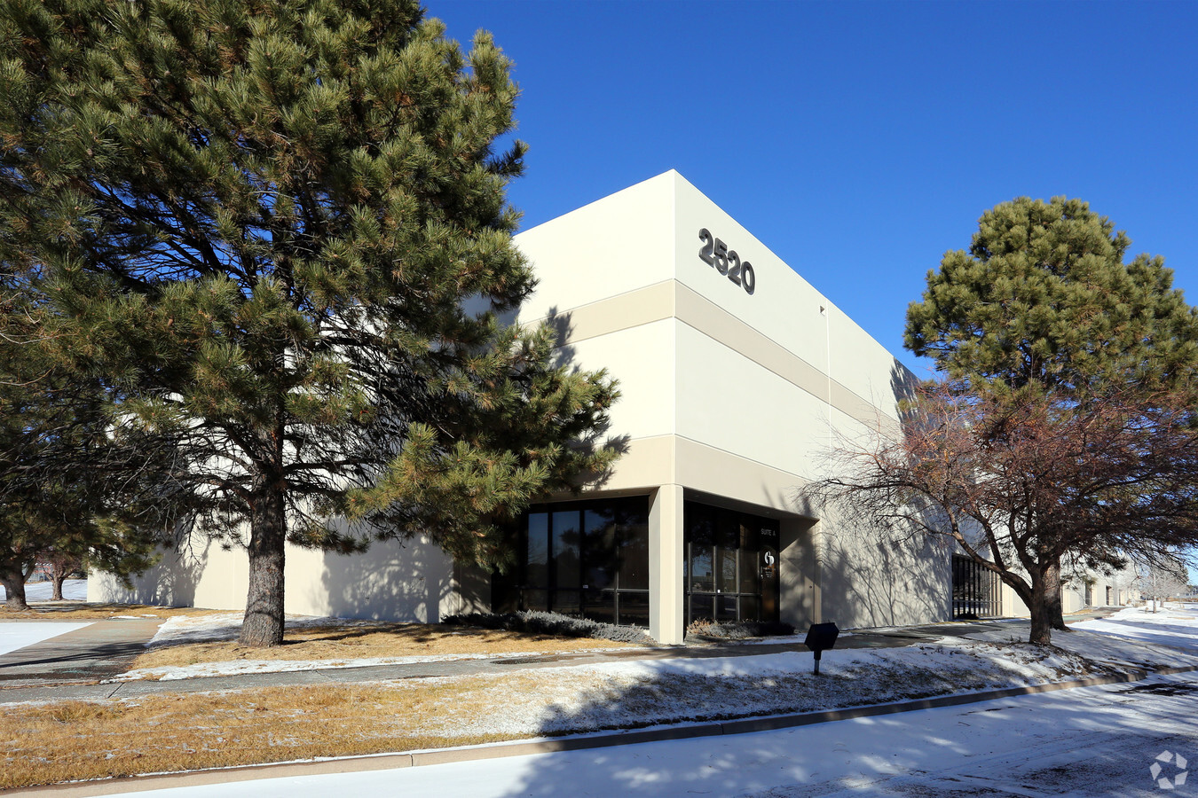
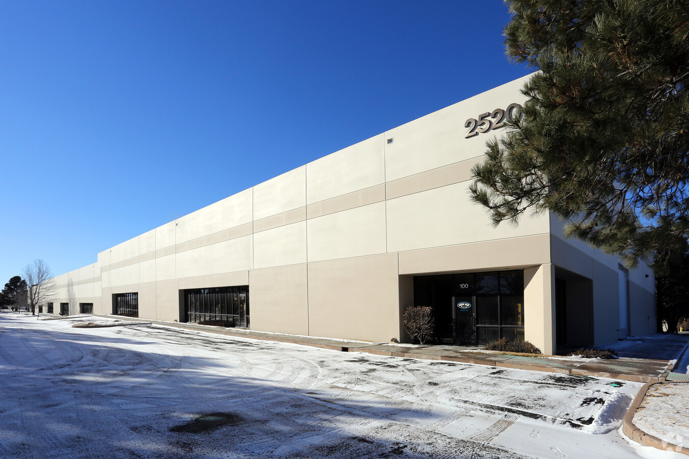
Property Record
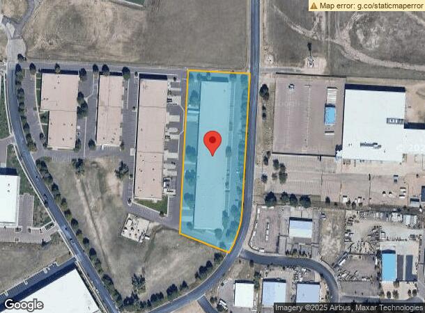
2520 Aviation Way, Colorado Springs, CO 80916

Current Lease Availabilities
NEARBY LISTINGS FOR SALE OR LEASE
Property Detail
2520 Aviation Way
Colorado Springs, CO
C C & F Airport Business Center Fil No 1
64361-02-001
LOT 1 BLK 1 CC & F AIRPORT BUSINESS CENTER FIL NO 1 COLO SPGS
Warehouse
El Paso
X
Colorado
08041C0761G
1
2023
4.58 AC
2024
Southeast
004008
Colorado Springs
75,952 SF
DEMOGRAPHICS near 2520 Aviation Way
1 Mile
3 Mile
5 Mile
2024 Total Population
7,988
75,609
181,921
2029 Population
8,248
78,991
190,212
Pop Growth 2024-2029
+ 3.25%
+ 4.47%
+ 4.56%
Average Age
33
34
35
2024 Total Households
2,534
26,522
68,115
HH Growth 2024-2029
+ 3.43%
+ 4.85%
+ 4.92%
Median Household Inc
$60,044
$58,887
$57,936
Avg Household Size
3.10
2.70
2.50
2024 Avg HH Vehicles
2.00
2.00
2.00
Median Home Value
$187,499
$267,536
$291,643
Median Year Built
1995
1987
1981
Nearby Places
- Restaurants
- Banks
- Shops
- Fitness
- Groceries
PUBLIC TRANSPORTATION
AIRPORT
City of Colorado Springs Municipal
DRIVE
WALK
Distance
City of Colorado Springs Municipal
13 min
5.6 mi
Freight Ports
Tulsa Port Of Catoosa
DRIVE
WALK
Distance
Tulsa Port Of Catoosa
738 min
692.1 mi
Nearby Properties
Address
Land Use
TOTAL SIZE
Lot Size
Zoning
Address
Land Use
TOTAL SIZE
Lot Size
Zoning
3,486,127 SF
69.25 AC
APD AO APZ
Address
Land Use
TOTAL SIZE
Lot Size
Zoning
339,516 SF
1,090.76 AC
APD RPZ AO
Address
Land Use
TOTAL SIZE
Lot Size
Zoning
233,194 SF
30 AC
R1-6 SS AO
Address
Land Use
TOTAL SIZE
Lot Size
Zoning
185,508 SF
16.48 AC
PIP2/CR SS
Address
Land Use
TOTAL SIZE
Lot Size
Zoning
200,642 SF
6.65 AC
PBC HR AO
Address
Land Use
TOTAL SIZE
Lot Size
Zoning
704,240 SF
41.99 AC
PIP2/CR UV
Address
Land Use
TOTAL SIZE
Lot Size
Zoning
278,331 SF
324.19 AC
Address
Land Use
TOTAL SIZE
Lot Size
Zoning
117,648 SF
3,971.89 AC
APD
Address
Land Use
TOTAL SIZE
Lot Size
Zoning
100,020 SF
9.03 AC
Address
Land Use
TOTAL SIZE
Lot Size
Zoning
89,487 SF
Address
Land Use
TOTAL SIZE
Lot Size
Zoning
210,964 SF
27.40 AC
PIP2 AO AP
Address
Land Use
TOTAL SIZE
Lot Size
Zoning
58,240 SF
4.10 AC
PIP2/CR AO
Address
Land Use
TOTAL SIZE
Lot Size
Zoning
124,597 SF
10.89 AC
PIP2/CR AO
Address
Land Use
TOTAL SIZE
Lot Size
Zoning
130,569 SF
3.22 AC
Address
Land Use
TOTAL SIZE
Lot Size
Zoning
162,945 SF
20.05 AC
PIP2/CR CU
Address
Land Use
TOTAL SIZE
Lot Size
Zoning
135,296 SF
11.67 AC
PIP2/CR UV
Address
Land Use
TOTAL SIZE
Lot Size
Zoning
131,040 SF
8.50 AC
PIP2/CR AO
Address
Land Use
TOTAL SIZE
Lot Size
Zoning
109,200 SF
6.13 AC
PIP2/CR AO
Address
Land Use
TOTAL SIZE
Lot Size
Zoning
23,535 SF
15.91 AC
PIP2/CR AO
Address
Land Use
TOTAL SIZE
Lot Size
Zoning
12.69 AC
APD RPZ AO
Address
Land Use
TOTAL SIZE
Lot Size
Zoning
70,466 SF
4.26 AC
OC AO
Address
Land Use
TOTAL SIZE
Lot Size
Zoning
131,040 SF
9.68 AC
PIP2 AO
Address
Land Use
TOTAL SIZE
Lot Size
Zoning
98,638 SF
7.22 AC
PBC AO
Address
Land Use
TOTAL SIZE
Lot Size
Zoning
99,960 SF
8.21 AC
PIP2 AO
Address
Land Use
TOTAL SIZE
Lot Size
Zoning
117,631 SF
4.64 AC
PBC HR AO
Address
Land Use
TOTAL SIZE
Lot Size
Zoning
217,418 SF
13.05 AC
SU AO
Address
Land Use
TOTAL SIZE
Lot Size
Zoning
48,255 SF
17.35 AC
A-5 CAD-O
Address
Land Use
TOTAL SIZE
Lot Size
Zoning
78,815 SF
Address
Land Use
TOTAL SIZE
Lot Size
Zoning
69,078 SF
0.03 AC
Address
Land Use
TOTAL SIZE
Lot Size
Zoning
125,060 SF
8.01 AC
PIP2/CR AO
The World's #1 Commercial Real Estate Marketplace
Connect with us
© 2025 CoStar Group
The information above has been obtained from sources believed reliable. While we do not doubt its accuracy we have not verified it and make no guarantee, warranty or representation about it. It is your responsibility to independently confirm its accuracy and completeness. Any projections, opinions, assumptions, or estimates used are for example only and do not represent the current or future performance of the property. The value of this transaction to you depends on tax and other factors which should be evaluated by your tax, financial, and legal advisors. You and your advisors should conduct a careful, independent investigation of the property to determine to your satisfaction the suitability of the property for your needs.