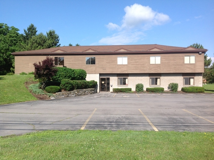
Property Record
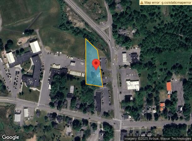
2521 Us Route 11 N, La Fayette, NY 13084
Current Lease Availabilities
NEARBY LISTINGS FOR SALE OR LEASE
Property Detail
2521 Us Route 11 N
313400-019-000-0001-006-002-0000
FL 59
Officebuilding
Onondaga
X
New York
36067C0363F
6.002
2024
1.07 AC
2023
SE Outer Onondaga County
015800
Syracuse
3,000 SF
Syracuse, NY
DEMOGRAPHICS near 2521 Us Route 11 N
1 Mile
3 Mile
5 Mile
2024 Total Population
678
3,444
6,433
2029 Population
660
3,362
6,208
Pop Growth 2024-2029
(2.65%)
(2.38%)
(3.50%)
Average Age
45
44
45
2024 Total Households
283
1,434
2,711
HH Growth 2024-2029
(2.83%)
(2.51%)
(3.87%)
Median Household Inc
$105,000
$99,095
$85,604
Avg Household Size
2.30
2.30
2.30
2024 Avg HH Vehicles
2.00
2.00
2.00
Median Home Value
$208,421
$187,728
$179,403
Median Year Built
1972
1971
1973
Nearby Places
- Restaurants
- Banks
- Shops
- Fitness
- Groceries
PUBLIC TRANSPORTATION
AIRPORT
Syracuse Hancock International
DRIVE
WALK
Distance
Syracuse Hancock International
26 min
18.6 mi
Freight Ports
Albany, NY Port
DRIVE
WALK
Distance
Albany, NY Port
184 min
156.0 mi
Nearby Properties
Address
Land Use
TOTAL SIZE
Lot Size
Zoning
Address
Land Use
TOTAL SIZE
Lot Size
Zoning
97,985 SF
46.75 AC
06 - INDUS
Address
Land Use
TOTAL SIZE
Lot Size
Zoning
64,494 SF
24.28 AC
05 - COMME
Address
Land Use
TOTAL SIZE
Lot Size
Zoning
8,700 SF
11.42 AC
06 - INDUS
Address
Land Use
TOTAL SIZE
Lot Size
Zoning
1,248 SF
26.53 AC
07 - MIXED
Address
Land Use
TOTAL SIZE
Lot Size
Zoning
22,842 SF
4.17 AC
07 - MIXED
Address
Land Use
TOTAL SIZE
Lot Size
Zoning
22.30 AC
04 - FARM
Address
Land Use
TOTAL SIZE
Lot Size
Zoning
7,030 SF
7 AC
07 - MIXED
Address
Land Use
TOTAL SIZE
Lot Size
Zoning
42,075 SF
7.99 AC
07 - MIXED
Address
Land Use
TOTAL SIZE
Lot Size
Zoning
7,854 SF
6.49 AC
06 - INDUS
Address
Land Use
TOTAL SIZE
Lot Size
Zoning
9,504 SF
18.50 AC
05 - COMME
Address
Land Use
TOTAL SIZE
Lot Size
Zoning
10,480 SF
12.03 AC
07 - MIXED
Address
Land Use
TOTAL SIZE
Lot Size
Zoning
15,080 SF
5.36 AC
07 - MIXED
Address
Land Use
TOTAL SIZE
Lot Size
Zoning
30,662 SF
3.76 AC
07 - MIXED
Address
Land Use
TOTAL SIZE
Lot Size
Zoning
17,430 SF
4.74 AC
07 - MIXED
Address
Land Use
TOTAL SIZE
Lot Size
Zoning
7,196 SF
7.68 AC
05 - COMME
Address
Land Use
TOTAL SIZE
Lot Size
Zoning
840 SF
9.36 AC
04 - FARM
Address
Land Use
TOTAL SIZE
Lot Size
Zoning
4,164 SF
8.91 AC
07 - MIXED
Address
Land Use
TOTAL SIZE
Lot Size
Zoning
9,666 SF
3.60 AC
05 - COMME
Address
Land Use
TOTAL SIZE
Lot Size
Zoning
6,612 SF
0.89 AC
07 - MIXED
Address
Land Use
TOTAL SIZE
Lot Size
Zoning
12,000 SF
8.02 AC
07 - MIXED
Address
Land Use
TOTAL SIZE
Lot Size
Zoning
8,224 SF
1.50 AC
07 - MIXED
Address
Land Use
TOTAL SIZE
Lot Size
Zoning
17,668 SF
12.24 AC
04 - FARM
Address
Land Use
TOTAL SIZE
Lot Size
Zoning
4,648 SF
83.73 AC
05 - COMME
Address
Land Use
TOTAL SIZE
Lot Size
Zoning
5,577 SF
3.82 AC
06 - INDUS
Address
Land Use
TOTAL SIZE
Lot Size
Zoning
3,112 SF
1.92 AC
07 - MIXED
Address
Land Use
TOTAL SIZE
Lot Size
Zoning
2,000 SF
1.59 AC
07 - MIXED
Address
Land Use
TOTAL SIZE
Lot Size
Zoning
2,766 SF
88.84 AC
04 - FARM
Address
Land Use
TOTAL SIZE
Lot Size
Zoning
12,594 SF
6 AC
07 - MIXED
Address
Land Use
TOTAL SIZE
Lot Size
Zoning
36.24 AC
06 - INDUS
The World's #1 Commercial Real Estate Marketplace
Connect with us
© 2025 CoStar Group
The information above has been obtained from sources believed reliable. While we do not doubt its accuracy we have not verified it and make no guarantee, warranty or representation about it. It is your responsibility to independently confirm its accuracy and completeness. Any projections, opinions, assumptions, or estimates used are for example only and do not represent the current or future performance of the property. The value of this transaction to you depends on tax and other factors which should be evaluated by your tax, financial, and legal advisors. You and your advisors should conduct a careful, independent investigation of the property to determine to your satisfaction the suitability of the property for your needs.