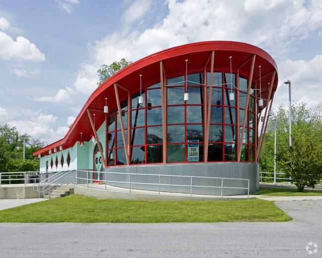
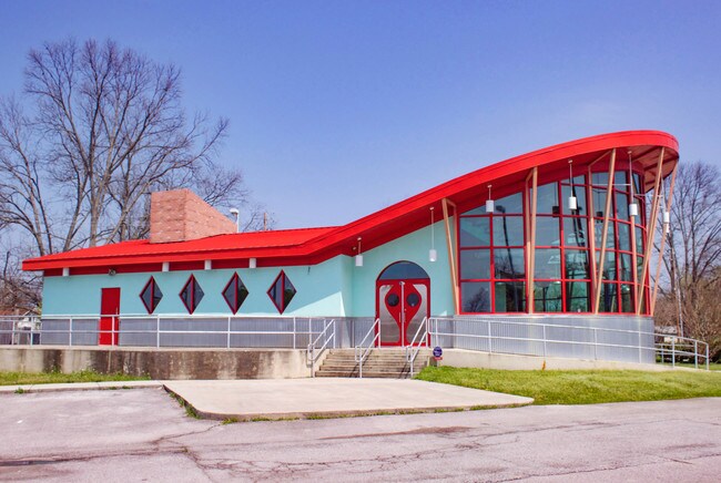
Property Record
255 Pratt Ave Ne, Huntsville, AL 35801

NEARBY LISTINGS FOR SALE OR LEASE
Property Detail
255 Pratt Ave Ne
Huntsville, AL
Quigley Map R/S Pratt Ave & Pt
14-07-36-2-001-075.000
LOT 2 QUIGLEY MAP RESUBDIVISION OF PART PRATT AVE & BLK 318 PB # 20080529000346160
Restaurantdrivein
Madison
AE
Alabama
01089C0327F
2
2025
0.76 AC
2025
South Huntsville
001000
Huntsville
2,906 SF
DEMOGRAPHICS near 255 Pratt Ave Ne
1 Mile
3 Mile
5 Mile
2024 Total Population
8,319
66,588
125,047
2029 Population
9,350
73,738
138,461
Pop Growth 2024-2029
+ 12.39%
+ 10.74%
+ 10.73%
Average Age
43
39
39
2024 Total Households
4,049
28,048
52,671
HH Growth 2024-2029
+ 12.79%
+ 11.70%
+ 11.48%
Median Household Inc
$71,902
$55,441
$49,777
Avg Household Size
1.80
2.10
2.10
2024 Avg HH Vehicles
1.00
2.00
2.00
Median Home Value
$334,234
$205,303
$178,264
Median Year Built
1963
1966
1971
Nearby Places
Map Layers
Map Styles
 Street
 Aerial
- Restaurants
- Banks
- Shops
- Fitness
- Groceries
PUBLIC TRANSPORTATION
AIRPORT
Huntsville International-Carl T Jones Field
DRIVE
WALK
Distance
Huntsville International-Carl T Jones Field
21 min
14.6 mi
Freight Ports
Port of Mobile
DRIVE
WALK
Distance
Port of Mobile
388 min
355.8 mi
SALE & LEASE HISTORY
LISTING DATE
SALE/LEASE

Sep 25, 2016
For Lease
May 23, 2017
For Sale
Jan 13, 2017
For Lease
Nearby Properties
Address
Land Use
TOTAL SIZE
Lot Size
Zoning
Address
Land Use
TOTAL SIZE
Lot Size
Zoning
91,060 SF
8.37 AC
Address
Land Use
TOTAL SIZE
Lot Size
Zoning
208,719 SF
26.55 AC
Address
Land Use
TOTAL SIZE
Lot Size
Zoning
67,440 SF
10.04 AC
Address
Land Use
TOTAL SIZE
Lot Size
Zoning
92,055 SF
4.83 AC
Address
Land Use
TOTAL SIZE
Lot Size
Zoning
5,577 SF
12.72 AC
Address
Land Use
TOTAL SIZE
Lot Size
Zoning
76,442 SF
Address
Land Use
TOTAL SIZE
Lot Size
Zoning
67,868 SF
11 AC
Address
Land Use
TOTAL SIZE
Lot Size
Zoning
0.77 AC
Address
Land Use
TOTAL SIZE
Lot Size
Zoning
18,182 SF
Address
Land Use
TOTAL SIZE
Lot Size
Zoning
61,559 SF
5.15 AC
Address
Land Use
TOTAL SIZE
Lot Size
Zoning
47,696 SF
1.63 AC
Address
Land Use
TOTAL SIZE
Lot Size
Zoning
76,079 SF
12.71 AC
Address
Land Use
TOTAL SIZE
Lot Size
Zoning
61,712 SF
0.01 AC
Address
Land Use
TOTAL SIZE
Lot Size
Zoning
9,940 SF
4.59 AC
Address
Land Use
TOTAL SIZE
Lot Size
Zoning
14,630 SF
13.44 AC
Address
Land Use
TOTAL SIZE
Lot Size
Zoning
2,532 SF
22.76 AC
Address
Land Use
TOTAL SIZE
Lot Size
Zoning
15,121 SF
1.73 AC
Address
Land Use
TOTAL SIZE
Lot Size
Zoning
Address
Land Use
TOTAL SIZE
Lot Size
Zoning
42,231 SF
6.69 AC
Address
Land Use
TOTAL SIZE
Lot Size
Zoning
17,333 SF
1.65 AC
Address
Land Use
TOTAL SIZE
Lot Size
Zoning
21,068 SF
1.39 AC
Address
Land Use
TOTAL SIZE
Lot Size
Zoning
17,985 SF
0.74 AC
Address
Land Use
TOTAL SIZE
Lot Size
Zoning
16,379 SF
0.86 AC
Address
Land Use
TOTAL SIZE
Lot Size
Zoning
33,558 SF
4.30 AC
Address
Land Use
TOTAL SIZE
Lot Size
Zoning
19,360 SF
6.24 AC
Address
Land Use
TOTAL SIZE
Lot Size
Zoning
2,471 SF
14.44 AC
Address
Land Use
TOTAL SIZE
Lot Size
Zoning
31,775 SF
3.89 AC
Address
Land Use
TOTAL SIZE
Lot Size
Zoning
12,568 SF
0.41 AC
Address
Land Use
TOTAL SIZE
Lot Size
Zoning
19,999 SF
14.93 AC
Address
Land Use
TOTAL SIZE
Lot Size
Zoning
12,989 SF
2.07 AC
The World's #1 Commercial Real Estate Marketplace
Connect with us
© 2026 CoStar Group
The information above has been obtained from sources believed reliable. While we do not doubt its accuracy we have not verified it and make no guarantee, warranty or representation about it. It is your responsibility to independently confirm its accuracy and completeness. Any projections, opinions, assumptions, or estimates used are for example only and do not represent the current or future performance of the property. The value of this transaction to you depends on tax and other factors which should be evaluated by your tax, financial, and legal advisors. You and your advisors should conduct a careful, independent investigation of the property to determine to your satisfaction the suitability of the property for your needs.