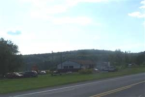
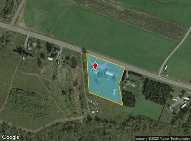
Property Record
2564 Us Highway 20, Richfield Springs, NY 13439
NEARBY LISTINGS FOR SALE OR LEASE
-
-
View all Richfield Springs listings for sale on LoopNet.com
Property Detail
2564 Us Highway 20
365689-012-000-0001-009-021-0000
003 0 0
Commercialofficeresidentialmixeduse
Otsego
X
New York
36077C0160E
9.021
2024
2.66 AC
2023
Otsego County
590301
Albany/Schenectady/Troy
2,210 SF
Oneonta, NY
DEMOGRAPHICS near 2564 Us Highway 20
1 Mile
3 Mile
5 Mile
2024 Total Population
97
1,351
3,505
2029 Population
97
1,322
3,448
Pop Growth 2024-2029
0.00%
(2.15%)
(1.63%)
Average Age
46
45
44
2024 Total Households
41
588
1,481
HH Growth 2024-2029
+ 2.44%
(2.21%)
(1.62%)
Median Household Inc
$37,500
$51,667
$53,790
Avg Household Size
2.30
2.30
2.30
2024 Avg HH Vehicles
2.00
2.00
2.00
Median Home Value
$191,666
$147,647
$154,842
Median Year Built
1960
1948
1949
Nearby Places
- Restaurants
- Banks
- Shops
- Fitness
- Groceries
Nearby Properties
Address
Land Use
TOTAL SIZE
Lot Size
Zoning
Address
Land Use
TOTAL SIZE
Lot Size
Zoning
144,200 SF
10.75 AC
Address
Land Use
TOTAL SIZE
Lot Size
Zoning
51,482 SF
6.88 AC
01 - NOT Z
Address
Land Use
TOTAL SIZE
Lot Size
Zoning
11,713 SF
1.88 AC
01 - NOT Z
Address
Land Use
TOTAL SIZE
Lot Size
Zoning
9,692 SF
0.61 AC
01 - NOT Z
Address
Land Use
TOTAL SIZE
Lot Size
Zoning
5,304 SF
2.06 AC
01 - NOT Z
Address
Land Use
TOTAL SIZE
Lot Size
Zoning
3,672 SF
1.17 AC
01 - NOT Z
Address
Land Use
TOTAL SIZE
Lot Size
Zoning
12,820 SF
0.99 AC
Address
Land Use
TOTAL SIZE
Lot Size
Zoning
10,304 SF
11.03 AC
01 - NOT Z
Address
Land Use
TOTAL SIZE
Lot Size
Zoning
4,880 SF
0.25 AC
01 - NOT Z
Address
Land Use
TOTAL SIZE
Lot Size
Zoning
51,482 SF
2.80 AC
01 - NOT Z
Address
Land Use
TOTAL SIZE
Lot Size
Zoning
26.70 AC
Address
Land Use
TOTAL SIZE
Lot Size
Zoning
2,946 SF
2.45 AC
01 - NOT Z
Address
Land Use
TOTAL SIZE
Lot Size
Zoning
3,600 SF
2.19 AC
01 - NOT Z
Address
Land Use
TOTAL SIZE
Lot Size
Zoning
2.74 AC
01 - NOT Z
Address
Land Use
TOTAL SIZE
Lot Size
Zoning
12,622 SF
2.09 AC
01 - NOT Z
Address
Land Use
TOTAL SIZE
Lot Size
Zoning
1,656 SF
0.19 AC
01 - NOT Z
Address
Land Use
TOTAL SIZE
Lot Size
Zoning
7,650 SF
0.30 AC
01 - NOT Z
Address
Land Use
TOTAL SIZE
Lot Size
Zoning
3.36 AC
01 - NOT Z
Address
Land Use
TOTAL SIZE
Lot Size
Zoning
3,704 SF
0.34 AC
01 - NOT Z
Address
Land Use
TOTAL SIZE
Lot Size
Zoning
4,457 SF
0.95 AC
01 - NOT Z
Address
Land Use
TOTAL SIZE
Lot Size
Zoning
1,792 SF
0.47 AC
01 - NOT Z
Address
Land Use
TOTAL SIZE
Lot Size
Zoning
2,912 SF
116.20 AC
Address
Land Use
TOTAL SIZE
Lot Size
Zoning
12.68 AC
1
Address
Land Use
TOTAL SIZE
Lot Size
Zoning
5,133 SF
0.69 AC
01 - NOT Z
Address
Land Use
TOTAL SIZE
Lot Size
Zoning
0.12 AC
01 - NOT Z
Address
Land Use
TOTAL SIZE
Lot Size
Zoning
1.73 AC
01 - NOT Z
Address
Land Use
TOTAL SIZE
Lot Size
Zoning
1.18 AC
01 - NOT Z
Address
Land Use
TOTAL SIZE
Lot Size
Zoning
8,820 SF
5.84 AC
7000
Address
Land Use
TOTAL SIZE
Lot Size
Zoning
309.81 AC
01 - NOT Z
Address
Land Use
TOTAL SIZE
Lot Size
Zoning
2,609 SF
338.71 AC
01 - NOT Z
The World's #1 Commercial Real Estate Marketplace
Connect with us
© 2025 CoStar Group
The information above has been obtained from sources believed reliable. While we do not doubt its accuracy we have not verified it and make no guarantee, warranty or representation about it. It is your responsibility to independently confirm its accuracy and completeness. Any projections, opinions, assumptions, or estimates used are for example only and do not represent the current or future performance of the property. The value of this transaction to you depends on tax and other factors which should be evaluated by your tax, financial, and legal advisors. You and your advisors should conduct a careful, independent investigation of the property to determine to your satisfaction the suitability of the property for your needs.