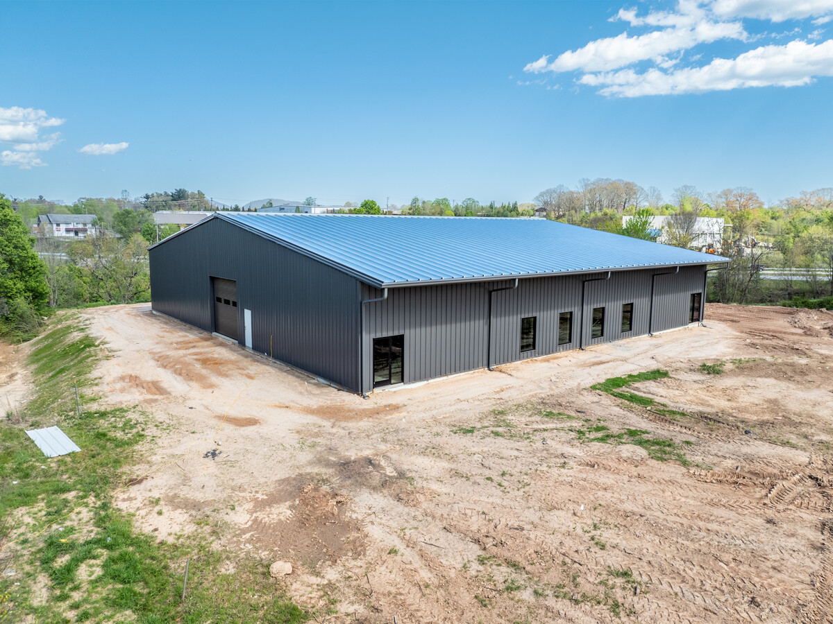
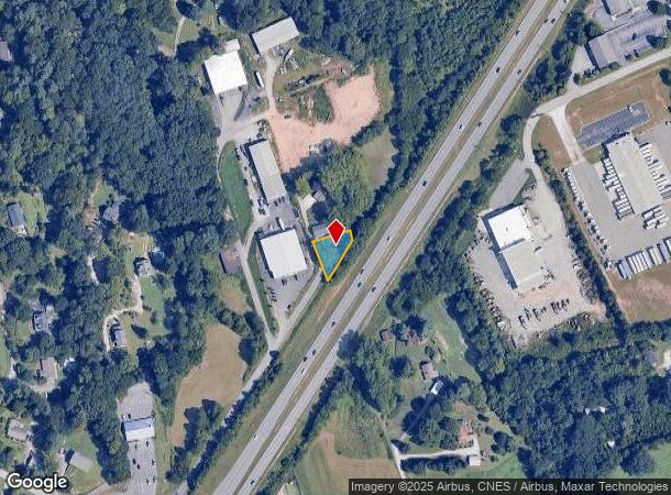
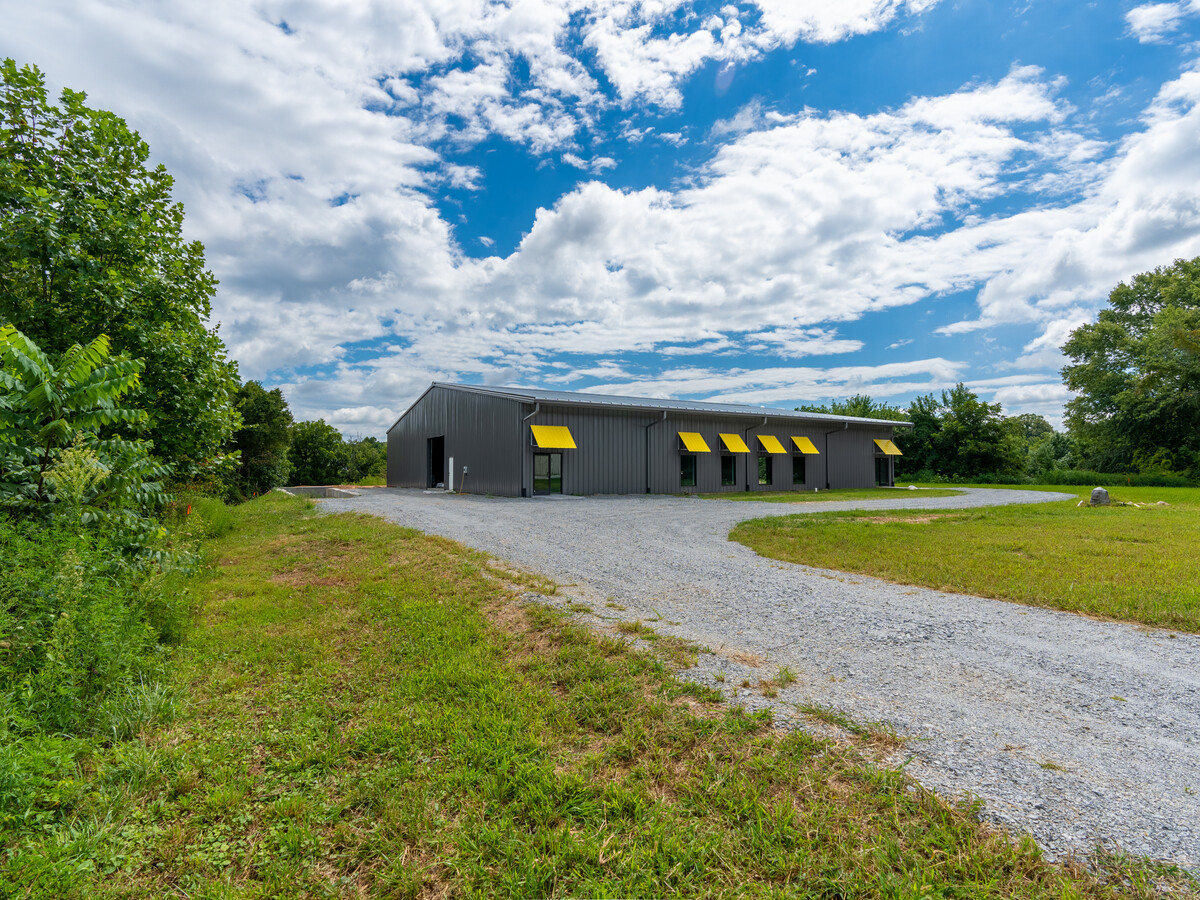
Property Record
220 Marlowe Dr, Mills River, NC 28759
NEARBY LISTINGS FOR SALE OR LEASE
Property Detail
220 Marlowe Dr
Asheville, NC
Town Of Mills River
9930045
Henderson
Sfr
North Carolina
X
0.25 AC
3700964200K
Henderson County
1,056 SF
Asheville
DEMOGRAPHICS near 220 Marlowe Dr
1 Mile
3 Mile
5 Mile
2024 Total Population
1,328
13,585
45,273
2029 Population
1,388
14,095
47,047
Pop Growth 2024-2029
+ 4.52%
+ 3.75%
+ 3.92%
Average Age
43
43
42
2024 Total Households
513
5,428
18,662
HH Growth 2024-2029
+ 4.68%
+ 3.76%
+ 3.73%
Median Household Inc
$96,609
$74,003
$72,498
Avg Household Size
2.60
2.50
2.40
2024 Avg HH Vehicles
2.00
2.00
2.00
Median Home Value
$328,894
$332,336
$333,522
Median Year Built
1999
1995
1995
Nearby Places
- Restaurants
- Banks
- Shops
- Fitness
- Groceries
PUBLIC TRANSPORTATION
AIRPORT
Asheville Regional
DRIVE
WALK
Distance
Asheville Regional
5 min
3.0 mi
Freight Ports
North Charleston Terminal
DRIVE
WALK
Distance
North Charleston Terminal
275 min
244.3 mi
Nearby Properties
Address
Land Use
TOTAL SIZE
Lot Size
Zoning
Address
Land Use
TOTAL SIZE
Lot Size
Zoning
18,224.79 AC
9933757~R4
Address
Land Use
TOTAL SIZE
Lot Size
Zoning
5,600 SF
121.14 AC
10003355~R
Address
Land Use
TOTAL SIZE
Lot Size
Zoning
281,505 SF
38.35 AC
10000070~M
Address
Land Use
TOTAL SIZE
Lot Size
Zoning
107,408 SF
21.92 AC
EMP
Address
Land Use
TOTAL SIZE
Lot Size
Zoning
198,705 SF
32.46 AC
HB
Address
Land Use
TOTAL SIZE
Lot Size
Zoning
481,731 SF
86.32 AC
1009658~I
Address
Land Use
TOTAL SIZE
Lot Size
Zoning
21.70 AC
10005690~M
Address
Land Use
TOTAL SIZE
Lot Size
Zoning
365,659 SF
38.28 AC
9958527~M-
Address
Land Use
TOTAL SIZE
Lot Size
Zoning
86,393 SF
15.44 AC
PS
Address
Land Use
TOTAL SIZE
Lot Size
Zoning
15,366 SF
3.31 AC
10007972~M
Address
Land Use
TOTAL SIZE
Lot Size
Zoning
39.98 AC
10007822~M
Address
Land Use
TOTAL SIZE
Lot Size
Zoning
107,698 SF
25.53 AC
PS
Address
Land Use
TOTAL SIZE
Lot Size
Zoning
3,000 SF
48.13 AC
10010496~M
Address
Land Use
TOTAL SIZE
Lot Size
Zoning
15,493 SF
2.01 AC
EMP
Address
Land Use
TOTAL SIZE
Lot Size
Zoning
28,183 SF
5.88 AC
10010086~C
Address
Land Use
TOTAL SIZE
Lot Size
Zoning
77,152 SF
13.84 AC
9933538~MR
Address
Land Use
TOTAL SIZE
Lot Size
Zoning
112,100 SF
14.22 AC
9975597~MR
Address
Land Use
TOTAL SIZE
Lot Size
Zoning
83,741 SF
24.39 AC
9959040~MR
Address
Land Use
TOTAL SIZE
Lot Size
Zoning
178,825 SF
25.05 AC
1016341~MR
Address
Land Use
TOTAL SIZE
Lot Size
Zoning
237,185 SF
17.57 AC
9962196~MR
Address
Land Use
TOTAL SIZE
Lot Size
Zoning
51,090 SF
5.18 AC
1007612~C-
Address
Land Use
TOTAL SIZE
Lot Size
Zoning
3,190 SF
21.46 AC
1016340~MR
Address
Land Use
TOTAL SIZE
Lot Size
Zoning
90,000 SF
9.43 AC
1001311~MR
Address
Land Use
TOTAL SIZE
Lot Size
Zoning
47,129 SF
42.82 AC
10005418~M
Address
Land Use
TOTAL SIZE
Lot Size
Zoning
71,973 SF
6.71 AC
HB
Address
Land Use
TOTAL SIZE
Lot Size
Zoning
57,827 SF
1.68 AC
1017417~C-
Address
Land Use
TOTAL SIZE
Lot Size
Zoning
404,414 SF
27.75 AC
AI
Address
Land Use
TOTAL SIZE
Lot Size
Zoning
5,145 SF
18.75 AC
10002245~C
Address
Land Use
TOTAL SIZE
Lot Size
Zoning
109,243 SF
22.63 AC
AI
Address
Land Use
TOTAL SIZE
Lot Size
Zoning
142,457 SF
40.51 AC
1016823~MR
The World's #1 Commercial Real Estate Marketplace
Connect with us
© 2025 CoStar Group
The information above has been obtained from sources believed reliable. While we do not doubt its accuracy we have not verified it and make no guarantee, warranty or representation about it. It is your responsibility to independently confirm its accuracy and completeness. Any projections, opinions, assumptions, or estimates used are for example only and do not represent the current or future performance of the property. The value of this transaction to you depends on tax and other factors which should be evaluated by your tax, financial, and legal advisors. You and your advisors should conduct a careful, independent investigation of the property to determine to your satisfaction the suitability of the property for your needs.