Property Record
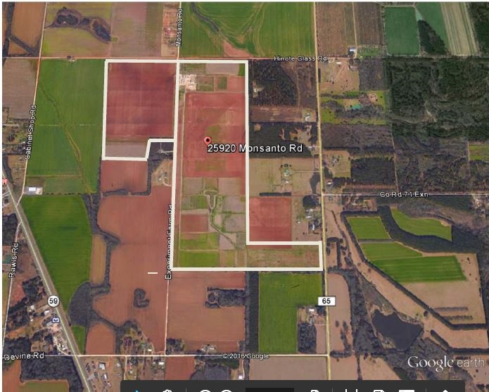
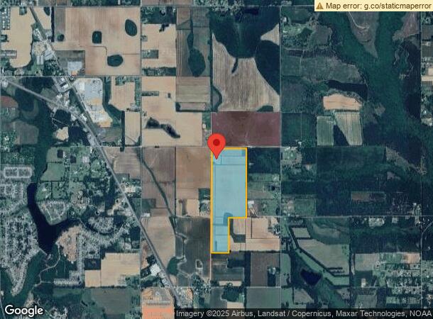
25920 Monsanto Rd, Loxley, AL 36551
NEARBY LISTINGS FOR SALE OR LEASE
-
-
View all Loxley listings for sale on LoopNet.com
Property Detail
25920 Monsanto Rd
42-06-24-0-000-002.001
98 AC(C) W1/2 OF NE1/4 & W1/4 OF NW1/4 OF SE1/4 LESS R/W SEC 24-T5S-R3E (ST/WD) IN#1993693
Officebuilding
Baldwin
X
Alabama
01003C0676M
99 AC
2023
Baldwin County
2023
Mobile
010906
Daphne-Fairhope-Foley, AL
4,237 SF
DEMOGRAPHICS near 25920 Monsanto Rd
1 Mile
3 Mile
5 Mile
2024 Total Population
368
9,979
20,342
2029 Population
419
11,345
23,066
Pop Growth 2024-2029
+ 13.86%
+ 13.69%
+ 13.39%
Average Age
37
38
38
2024 Total Households
131
3,446
7,154
HH Growth 2024-2029
+ 12.98%
+ 13.12%
+ 12.82%
Median Household Inc
$65,357
$61,031
$59,140
Avg Household Size
2.70
2.70
2.60
2024 Avg HH Vehicles
2.00
2.00
2.00
Median Home Value
$192,045
$191,505
$197,039
Median Year Built
2001
1997
1996
Nearby Places
- Restaurants
- Banks
- Shops
- Fitness
- Groceries
SALE & LEASE HISTORY
LISTING DATE
SALE/LEASE

Sep 24, 2016
For Sale
Nearby Properties
Address
Land Use
TOTAL SIZE
Lot Size
Zoning
Address
Land Use
TOTAL SIZE
Lot Size
Zoning
10,474 SF
14 AC
Address
Land Use
TOTAL SIZE
Lot Size
Zoning
24,873 SF
32 AC
Address
Land Use
TOTAL SIZE
Lot Size
Zoning
Address
Land Use
TOTAL SIZE
Lot Size
Zoning
1,233 SF
30 AC
Address
Land Use
TOTAL SIZE
Lot Size
Zoning
3,288 SF
15 AC
Address
Land Use
TOTAL SIZE
Lot Size
Zoning
52,339 SF
5.20 AC
Address
Land Use
TOTAL SIZE
Lot Size
Zoning
90,000 SF
15 AC
Address
Land Use
TOTAL SIZE
Lot Size
Zoning
20,520 SF
20 AC
Address
Land Use
TOTAL SIZE
Lot Size
Zoning
66,295 SF
4.13 AC
Address
Land Use
TOTAL SIZE
Lot Size
Zoning
77,858 SF
3.20 AC
Address
Land Use
TOTAL SIZE
Lot Size
Zoning
38,998 SF
20 AC
Address
Land Use
TOTAL SIZE
Lot Size
Zoning
24,920 SF
5.10 AC
Address
Land Use
TOTAL SIZE
Lot Size
Zoning
42,423 SF
2.95 AC
Address
Land Use
TOTAL SIZE
Lot Size
Zoning
3,000 SF
5.70 AC
Address
Land Use
TOTAL SIZE
Lot Size
Zoning
26,742 SF
1.90 AC
Address
Land Use
TOTAL SIZE
Lot Size
Zoning
Address
Land Use
TOTAL SIZE
Lot Size
Zoning
17,296 SF
2.52 AC
Address
Land Use
TOTAL SIZE
Lot Size
Zoning
Address
Land Use
TOTAL SIZE
Lot Size
Zoning
15,017 SF
3.95 AC
Address
Land Use
TOTAL SIZE
Lot Size
Zoning
17,021 SF
0.81 AC
Address
Land Use
TOTAL SIZE
Lot Size
Zoning
39,875 SF
4.38 AC
Address
Land Use
TOTAL SIZE
Lot Size
Zoning
2,803 SF
3.68 AC
Address
Land Use
TOTAL SIZE
Lot Size
Zoning
4.60 AC
Address
Land Use
TOTAL SIZE
Lot Size
Zoning
Address
Land Use
TOTAL SIZE
Lot Size
Zoning
8,048 SF
1.40 AC
Address
Land Use
TOTAL SIZE
Lot Size
Zoning
3,522 SF
3.15 AC
Address
Land Use
TOTAL SIZE
Lot Size
Zoning
7,000 SF
3.90 AC
Address
Land Use
TOTAL SIZE
Lot Size
Zoning
Address
Land Use
TOTAL SIZE
Lot Size
Zoning
8,214 SF
0.81 AC
Address
Land Use
TOTAL SIZE
Lot Size
Zoning
5,790 SF
1.14 AC
The World's #1 Commercial Real Estate Marketplace
Connect with us
© 2025 CoStar Group
The information above has been obtained from sources believed reliable. While we do not doubt its accuracy we have not verified it and make no guarantee, warranty or representation about it. It is your responsibility to independently confirm its accuracy and completeness. Any projections, opinions, assumptions, or estimates used are for example only and do not represent the current or future performance of the property. The value of this transaction to you depends on tax and other factors which should be evaluated by your tax, financial, and legal advisors. You and your advisors should conduct a careful, independent investigation of the property to determine to your satisfaction the suitability of the property for your needs.