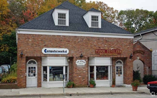
Property Record
260 Main St, Northport, NY 11768


Current Lease Availabilities
NEARBY LISTINGS FOR SALE OR LEASE
Property Detail
260 Main St
Nassau County-Suffolk County, NY
BLK LOT
0404-010-00-03-00-006-000
Suffolk
Commercialnec
New York
X
6
36103C0338H
0.19 AC
2024
Western Suffolk
2024
Long Island (New York)
200901
DEMOGRAPHICS near 260 Main St
1 Mile
3 Mile
5 Mile
2024 Total Population
8,628
46,865
124,758
2029 Population
8,442
45,951
122,465
Pop Growth 2024-2029
(2.16%)
(1.95%)
(1.84%)
Average Age
45
44
43
2024 Total Households
3,354
16,880
43,302
HH Growth 2024-2029
(2.42%)
(2.20%)
(2.09%)
Median Household Inc
$135,573
$148,437
$145,320
Avg Household Size
2.50
2.70
2.80
2024 Avg HH Vehicles
2.00
2.00
2.00
Median Home Value
$730,015
$721,174
$691,666
Median Year Built
1954
1958
1960
Nearby Places
Map Layers
Map Styles
 Street
 Aerial
- Restaurants
- Banks
- Shops
- Fitness
- Groceries
PUBLIC TRANSPORTATION
COMMUTER RAIL
Northport Station (Port Jefferson Branch - Long Island Rail Road)
DRIVE
WALK
Distance
Northport Station (Port Jefferson Branch - Long Island Rail Road)
6 min
2.2 mi
Greenlawn Station (Port Jefferson Branch - Long Island Rail Road)
DRIVE
WALK
Distance
Greenlawn Station (Port Jefferson Branch - Long Island Rail Road)
9 min
3.7 mi
AIRPORT
Long Island MacArthur
DRIVE
WALK
Distance
Long Island MacArthur
32 min
20.9 mi
John F Kennedy International
DRIVE
WALK
Distance
John F Kennedy International
58 min
36.4 mi
Freight Ports
NY - Red Hook Container Terminal
DRIVE
WALK
Distance
NY - Red Hook Container Terminal
67 min
42.7 mi
Nearby Properties
Address
Land Use
TOTAL SIZE
Lot Size
Zoning
Address
Land Use
TOTAL SIZE
Lot Size
Zoning
243.60 AC
I6
Address
Land Use
TOTAL SIZE
Lot Size
Zoning
0.80 AC
CR60
Address
Land Use
TOTAL SIZE
Lot Size
Zoning
300 AC
R80
Address
Land Use
TOTAL SIZE
Lot Size
Zoning
0.49 AC
VILLA
Address
Land Use
TOTAL SIZE
Lot Size
Zoning
2,764 SF
0.24 AC
HC
Address
Land Use
TOTAL SIZE
Lot Size
Zoning
1 AC
VILLA
Address
Land Use
TOTAL SIZE
Lot Size
Zoning
406.60 AC
R40
Address
Land Use
TOTAL SIZE
Lot Size
Zoning
43.30 AC
R40
Address
Land Use
TOTAL SIZE
Lot Size
Zoning
1,416 SF
0.86 AC
A
Address
Land Use
TOTAL SIZE
Lot Size
Zoning
0.57 AC
R20
Address
Land Use
TOTAL SIZE
Lot Size
Zoning
8.80 AC
R10
Address
Land Use
TOTAL SIZE
Lot Size
Zoning
6.50 AC
R40
Address
Land Use
TOTAL SIZE
Lot Size
Zoning
0.59 AC
R20
Address
Land Use
TOTAL SIZE
Lot Size
Zoning
42.20 AC
I1
Address
Land Use
TOTAL SIZE
Lot Size
Zoning
0.50 AC
R20
Address
Land Use
TOTAL SIZE
Lot Size
Zoning
30.80 AC
R40
Address
Land Use
TOTAL SIZE
Lot Size
Zoning
44.90 AC
R40
Address
Land Use
TOTAL SIZE
Lot Size
Zoning
10.14 AC
RRM
Address
Land Use
TOTAL SIZE
Lot Size
Zoning
0.46 AC
R20
Address
Land Use
TOTAL SIZE
Lot Size
Zoning
12 AC
RRM
Address
Land Use
TOTAL SIZE
Lot Size
Zoning
2.16 AC
CR200
Address
Land Use
TOTAL SIZE
Lot Size
Zoning
2.07 AC
CR200
Address
Land Use
TOTAL SIZE
Lot Size
Zoning
14.83 AC
R85
Address
Land Use
TOTAL SIZE
Lot Size
Zoning
16.54 AC
Address
Land Use
TOTAL SIZE
Lot Size
Zoning
1.94 AC
CR200
Address
Land Use
TOTAL SIZE
Lot Size
Zoning
15.80 AC
Address
Land Use
TOTAL SIZE
Lot Size
Zoning
44.60 AC
R40
Address
Land Use
TOTAL SIZE
Lot Size
Zoning
13.80 AC
R40
Address
Land Use
TOTAL SIZE
Lot Size
Zoning
44.62 AC
R40
Address
Land Use
TOTAL SIZE
Lot Size
Zoning
10.60 AC
RRM
The World's #1 Commercial Real Estate Marketplace
Connect with us
© 2025 CoStar Group
The information above has been obtained from sources believed reliable. While we do not doubt its accuracy we have not verified it and make no guarantee, warranty or representation about it. It is your responsibility to independently confirm its accuracy and completeness. Any projections, opinions, assumptions, or estimates used are for example only and do not represent the current or future performance of the property. The value of this transaction to you depends on tax and other factors which should be evaluated by your tax, financial, and legal advisors. You and your advisors should conduct a careful, independent investigation of the property to determine to your satisfaction the suitability of the property for your needs.