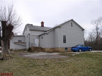
Property Record
2600 Highway 100, Gray Summit, MO 63039

NEARBY LISTINGS FOR SALE OR LEASE
-
-
View all Gray Summit listings for sale on LoopNet.com
Property Detail
2600 Highway 100
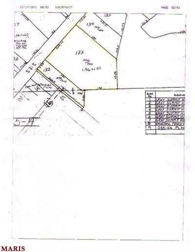
19-3-050-4-000-133000
PT SE SE, S OF HWY 100
Taxexempt
Franklin
X
Missouri
29071C0330E
2 AC
0
Franklin County
2025
St. Louis
800702
St. Louis, MO-IL
10,284 SF
DEMOGRAPHICS near 2600 Highway 100
1 Mile
3 Mile
5 Mile
2024 Total Population
1,654
6,581
17,258
2029 Population
1,695
6,746
17,758
Pop Growth 2024-2029
+ 2.48%
+ 2.51%
+ 2.90%
Average Age
41
41
42
2024 Total Households
658
2,646
6,919
HH Growth 2024-2029
+ 2.58%
+ 2.53%
+ 2.89%
Median Household Inc
$69,835
$67,885
$67,902
Avg Household Size
2.50
2.40
2.50
2024 Avg HH Vehicles
2.00
2.00
2.00
Median Home Value
$182,691
$183,504
$211,792
Median Year Built
1984
1984
1985
Nearby Places
Map Layers
Map Styles
 Street
 Aerial
- Restaurants
- Banks
- Shops
- Fitness
- Groceries
PUBLIC TRANSPORTATION
AIRPORT
St Louis Lambert International
DRIVE
WALK
Distance
St Louis Lambert International
56 min
42.1 mi
Nearby Properties
Address
Land Use
TOTAL SIZE
Lot Size
Zoning
Address
Land Use
TOTAL SIZE
Lot Size
Zoning
150,495 SF
59.50 AC
Address
Land Use
TOTAL SIZE
Lot Size
Zoning
61,091 SF
22.80 AC
ANU
Address
Land Use
TOTAL SIZE
Lot Size
Zoning
1,515 SF
232.80 AC
CD
Address
Land Use
TOTAL SIZE
Lot Size
Zoning
160,000 SF
8.70 AC
Address
Land Use
TOTAL SIZE
Lot Size
Zoning
2,205 SF
80 AC
SD
Address
Land Use
TOTAL SIZE
Lot Size
Zoning
17,690 SF
5 AC
Address
Land Use
TOTAL SIZE
Lot Size
Zoning
9,982 SF
1.50 AC
Address
Land Use
TOTAL SIZE
Lot Size
Zoning
10,126 SF
1.10 AC
Address
Land Use
TOTAL SIZE
Lot Size
Zoning
21,900 SF
2.20 AC
Address
Land Use
TOTAL SIZE
Lot Size
Zoning
13,100 SF
6.10 AC
Address
Land Use
TOTAL SIZE
Lot Size
Zoning
206,798 SF
10.60 AC
Address
Land Use
TOTAL SIZE
Lot Size
Zoning
1,748 SF
491.50 AC
ANU
Address
Land Use
TOTAL SIZE
Lot Size
Zoning
462 SF
239.60 AC
CD
Address
Land Use
TOTAL SIZE
Lot Size
Zoning
201,013 SF
13.60 AC
Address
Land Use
TOTAL SIZE
Lot Size
Zoning
2,880 SF
9.10 AC
CD
Address
Land Use
TOTAL SIZE
Lot Size
Zoning
270,948 SF
23.30 AC
Address
Land Use
TOTAL SIZE
Lot Size
Zoning
111,677 SF
15 AC
Address
Land Use
TOTAL SIZE
Lot Size
Zoning
9,000 SF
1.70 AC
CD
Address
Land Use
TOTAL SIZE
Lot Size
Zoning
57,940 SF
6.20 AC
Address
Land Use
TOTAL SIZE
Lot Size
Zoning
4,452 SF
643.20 AC
ANU
Address
Land Use
TOTAL SIZE
Lot Size
Zoning
9,320 SF
3.80 AC
CA
Address
Land Use
TOTAL SIZE
Lot Size
Zoning
8,760 SF
2 AC
CD
Address
Land Use
TOTAL SIZE
Lot Size
Zoning
72,320 SF
4.30 AC
Address
Land Use
TOTAL SIZE
Lot Size
Zoning
2.60 AC
Address
Land Use
TOTAL SIZE
Lot Size
Zoning
3,728 SF
1 AC
Address
Land Use
TOTAL SIZE
Lot Size
Zoning
8,720 SF
0.70 AC
Address
Land Use
TOTAL SIZE
Lot Size
Zoning
19,784 SF
5.20 AC
Address
Land Use
TOTAL SIZE
Lot Size
Zoning
Address
Land Use
TOTAL SIZE
Lot Size
Zoning
3,168 SF
3 AC
CA
The World's #1 Commercial Real Estate Marketplace
Connect with us
© 2026 CoStar Group
The information above has been obtained from sources believed reliable. While we do not doubt its accuracy we have not verified it and make no guarantee, warranty or representation about it. It is your responsibility to independently confirm its accuracy and completeness. Any projections, opinions, assumptions, or estimates used are for example only and do not represent the current or future performance of the property. The value of this transaction to you depends on tax and other factors which should be evaluated by your tax, financial, and legal advisors. You and your advisors should conduct a careful, independent investigation of the property to determine to your satisfaction the suitability of the property for your needs.