No Photo
Property Record
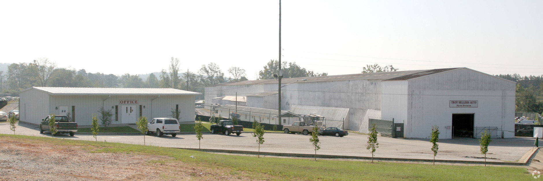
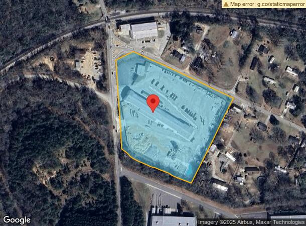
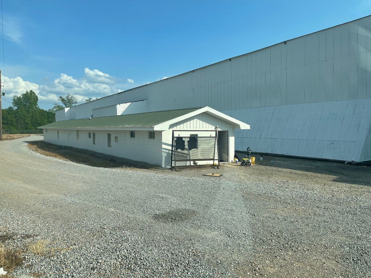
2601 Buttermilk Rd, Cottondale, AL 35453
NEARBY LISTINGS FOR SALE OR LEASE
-
-
View all Cottondale listings for sale on LoopNet.com
Property Detail
2601 Buttermilk Rd
Tuscaloosa, AL
Rosenau Estate 6/78 Facing Clements Rd T
30-07-26-4-004-010.000
BEG. NE COR LOT #19, ROSENAU ESTATES, 6/78, FACING CLEMENTS RD., TH. NE 5' (S) WITH RD. TO P.O.B., TH. NW WITH RD 725' (S),
Autorepair
Tuscaloosa
AE
Alabama
01125C0537G
19
2024
9.30 AC
2024
Tuscaloosa
010802
Birmingham
39,114 SF
DEMOGRAPHICS near 2601 Buttermilk Rd
1 Mile
3 Mile
5 Mile
2024 Total Population
2,289
19,320
55,971
2029 Population
2,638
22,001
64,145
Pop Growth 2024-2029
+ 15.25%
+ 13.88%
+ 14.60%
Average Age
41
41
37
2024 Total Households
953
7,923
23,743
HH Growth 2024-2029
+ 14.80%
+ 13.40%
+ 14.13%
Median Household Inc
$49,999
$65,195
$49,467
Avg Household Size
2.30
2.30
2.20
2024 Avg HH Vehicles
2.00
2.00
2.00
Median Home Value
$133,482
$186,718
$174,785
Median Year Built
1977
1989
1991
Nearby Places
- Restaurants
- Banks
- Shops
- Fitness
- Groceries
PUBLIC TRANSPORTATION
COMMUTER RAIL
Tuscaloosa Amtrak Station (Crescent - Amtrak)
DRIVE
WALK
Distance
Tuscaloosa Amtrak Station (Crescent - Amtrak)
12 min
8.8 mi
Freight Ports
Port of Mobile
DRIVE
WALK
Distance
Port of Mobile
243 min
204.4 mi
SALE & LEASE HISTORY
LISTING DATE
SALE/LEASE

May 13, 2021
For Sale
Nearby Properties
Address
Land Use
TOTAL SIZE
Lot Size
Zoning
Address
Land Use
TOTAL SIZE
Lot Size
Zoning
9,616 SF
30.17 AC
R4
Address
Land Use
TOTAL SIZE
Lot Size
Zoning
5,568 SF
50 AC
Address
Land Use
TOTAL SIZE
Lot Size
Zoning
32,616 SF
11 AC
Address
Land Use
TOTAL SIZE
Lot Size
Zoning
9,796 SF
14 AC
RMF1
Address
Land Use
TOTAL SIZE
Lot Size
Zoning
8,454 SF
5.30 AC
BH
Address
Land Use
TOTAL SIZE
Lot Size
Zoning
56,211 SF
2.05 AC
BH
Address
Land Use
TOTAL SIZE
Lot Size
Zoning
66,949 SF
3.60 AC
BH
Address
Land Use
TOTAL SIZE
Lot Size
Zoning
55,862 SF
11 AC
BH
Address
Land Use
TOTAL SIZE
Lot Size
Zoning
168,000 SF
3.70 AC
MG
Address
Land Use
TOTAL SIZE
Lot Size
Zoning
59,344 SF
13.73 AC
BH
Address
Land Use
TOTAL SIZE
Lot Size
Zoning
41,250 SF
2.22 AC
BH
Address
Land Use
TOTAL SIZE
Lot Size
Zoning
7,103 SF
4.91 AC
RMF1
Address
Land Use
TOTAL SIZE
Lot Size
Zoning
41,623 SF
5.39 AC
BH
Address
Land Use
TOTAL SIZE
Lot Size
Zoning
59,810 SF
1.48 AC
BH
Address
Land Use
TOTAL SIZE
Lot Size
Zoning
61,845 SF
5.50 AC
BN
Address
Land Use
TOTAL SIZE
Lot Size
Zoning
9,288 SF
4.49 AC
R4
Address
Land Use
TOTAL SIZE
Lot Size
Zoning
45,464 SF
1.91 AC
BH
Address
Land Use
TOTAL SIZE
Lot Size
Zoning
4,818 SF
13 AC
RMF1
Address
Land Use
TOTAL SIZE
Lot Size
Zoning
126,825 SF
9.30 AC
ML
Address
Land Use
TOTAL SIZE
Lot Size
Zoning
2,407 SF
3.19 AC
RMF1
Address
Land Use
TOTAL SIZE
Lot Size
Zoning
41,440 SF
7.50 AC
Address
Land Use
TOTAL SIZE
Lot Size
Zoning
3,112 SF
6.57 AC
Address
Land Use
TOTAL SIZE
Lot Size
Zoning
33,414 SF
35 AC
BH
Address
Land Use
TOTAL SIZE
Lot Size
Zoning
4,332 SF
3.78 AC
RMF1
Address
Land Use
TOTAL SIZE
Lot Size
Zoning
20,000 SF
2.65 AC
BH
Address
Land Use
TOTAL SIZE
Lot Size
Zoning
15,040 SF
9.20 AC
BH
Address
Land Use
TOTAL SIZE
Lot Size
Zoning
16,800 SF
15 AC
Address
Land Use
TOTAL SIZE
Lot Size
Zoning
42,848 SF
4.40 AC
BN
Address
Land Use
TOTAL SIZE
Lot Size
Zoning
28,420 SF
2.90 AC
BH
Address
Land Use
TOTAL SIZE
Lot Size
Zoning
23,555 SF
4.40 AC
BH
The World's #1 Commercial Real Estate Marketplace
Connect with us
© 2025 CoStar Group
The information above has been obtained from sources believed reliable. While we do not doubt its accuracy we have not verified it and make no guarantee, warranty or representation about it. It is your responsibility to independently confirm its accuracy and completeness. Any projections, opinions, assumptions, or estimates used are for example only and do not represent the current or future performance of the property. The value of this transaction to you depends on tax and other factors which should be evaluated by your tax, financial, and legal advisors. You and your advisors should conduct a careful, independent investigation of the property to determine to your satisfaction the suitability of the property for your needs.