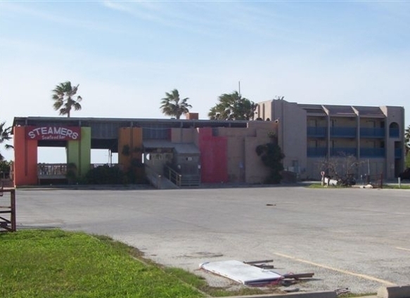
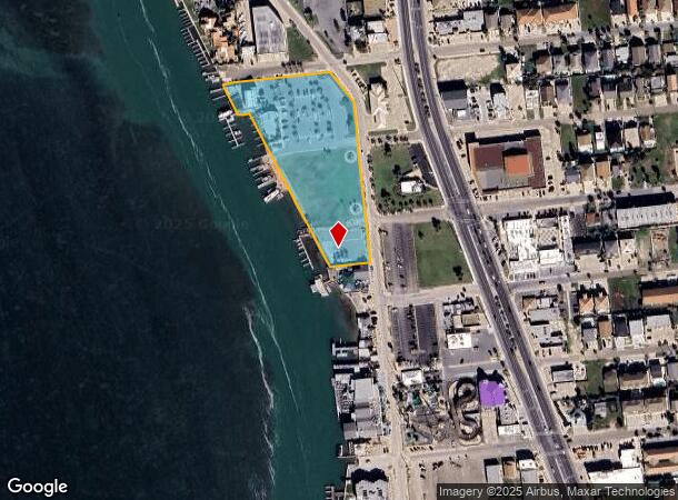
Property Record
2601 Laguna Dr, South Padre Island, TX 78597

NEARBY LISTINGS FOR SALE OR LEASE
Property Detail
2601 Laguna Dr
Brownsville-Harlingen, TX
Skipjack Bayfront Subdivision
676516-0000-001000
LOT 1A SKIPJACK BAYFRONT SUBDIVISION (2018 C1 3567 CCMR FILED 01/19/2017)
Commercialnec
Cameron
AE
Texas
48061C0510F
1a
2023
3.66 AC
2024
Outlying Cameron County
012305
Brownsville/Harlingen
6,669 SF
DEMOGRAPHICS near 2601 Laguna Dr
1 Mile
3 Mile
5 Mile
2024 Total Population
1,712
3,198
8,242
2029 Population
1,857
3,450
8,548
Pop Growth 2024-2029
+ 8.47%
+ 7.88%
+ 3.71%
Average Age
52
51
46
2024 Total Households
825
1,531
3,548
HH Growth 2024-2029
+ 8.48%
+ 7.97%
+ 4.51%
Median Household Inc
$73,124
$71,249
$59,121
Avg Household Size
2.10
2.10
2.30
2024 Avg HH Vehicles
2.00
1.00
1.00
Median Home Value
$336,232
$331,923
$254,923
Median Year Built
1986
1986
1985
Nearby Places
- Restaurants
- Banks
- Shops
- Fitness
- Groceries
PUBLIC TRANSPORTATION
AIRPORT
Brownsville/South Padre Island International
DRIVE
WALK
Distance
Brownsville/South Padre Island International
36 min
24.8 mi
Freight Ports
Port of Brownsville
DRIVE
WALK
Distance
Port of Brownsville
29 min
21.0 mi
Nearby Properties
Address
Land Use
TOTAL SIZE
Lot Size
Zoning
Address
Land Use
TOTAL SIZE
Lot Size
Zoning
269,790 SF
4.22 AC
Address
Land Use
TOTAL SIZE
Lot Size
Zoning
157,731 SF
6.50 AC
Address
Land Use
TOTAL SIZE
Lot Size
Zoning
109,178 SF
6.12 AC
Address
Land Use
TOTAL SIZE
Lot Size
Zoning
93,648 SF
2.39 AC
Address
Land Use
TOTAL SIZE
Lot Size
Zoning
98,836 SF
Address
Land Use
TOTAL SIZE
Lot Size
Zoning
94,964 SF
2.50 AC
D
Address
Land Use
TOTAL SIZE
Lot Size
Zoning
13.50 AC
Address
Land Use
TOTAL SIZE
Lot Size
Zoning
60,909 SF
3.36 AC
Address
Land Use
TOTAL SIZE
Lot Size
Zoning
64,215 SF
4.26 AC
Address
Land Use
TOTAL SIZE
Lot Size
Zoning
22,334 SF
141.41 AC
Address
Land Use
TOTAL SIZE
Lot Size
Zoning
Address
Land Use
TOTAL SIZE
Lot Size
Zoning
47,798 SF
1.32 AC
C
Address
Land Use
TOTAL SIZE
Lot Size
Zoning
25,680 SF
1 AC
Address
Land Use
TOTAL SIZE
Lot Size
Zoning
29,298 SF
1.17 AC
Address
Land Use
TOTAL SIZE
Lot Size
Zoning
48,117 SF
2.68 AC
C
Address
Land Use
TOTAL SIZE
Lot Size
Zoning
49,078 SF
1.66 AC
C
Address
Land Use
TOTAL SIZE
Lot Size
Zoning
111,604 SF
2.25 AC
C
Address
Land Use
TOTAL SIZE
Lot Size
Zoning
18,952 SF
34.95 AC
Address
Land Use
TOTAL SIZE
Lot Size
Zoning
52,131 SF
2.01 AC
C
Address
Land Use
TOTAL SIZE
Lot Size
Zoning
8,048 SF
4.80 AC
D
Address
Land Use
TOTAL SIZE
Lot Size
Zoning
31,066 SF
1.46 AC
C
Address
Land Use
TOTAL SIZE
Lot Size
Zoning
65,490 SF
1.86 AC
Address
Land Use
TOTAL SIZE
Lot Size
Zoning
20,309 SF
0.25 AC
Address
Land Use
TOTAL SIZE
Lot Size
Zoning
15,824 SF
Address
Land Use
TOTAL SIZE
Lot Size
Zoning
11,706 SF
2.91 AC
C
Address
Land Use
TOTAL SIZE
Lot Size
Zoning
9,081 SF
1.62 AC
C
Address
Land Use
TOTAL SIZE
Lot Size
Zoning
28,748 SF
1.28 AC
Address
Land Use
TOTAL SIZE
Lot Size
Zoning
Address
Land Use
TOTAL SIZE
Lot Size
Zoning
The World's #1 Commercial Real Estate Marketplace
Connect with us
© 2025 CoStar Group
The information above has been obtained from sources believed reliable. While we do not doubt its accuracy we have not verified it and make no guarantee, warranty or representation about it. It is your responsibility to independently confirm its accuracy and completeness. Any projections, opinions, assumptions, or estimates used are for example only and do not represent the current or future performance of the property. The value of this transaction to you depends on tax and other factors which should be evaluated by your tax, financial, and legal advisors. You and your advisors should conduct a careful, independent investigation of the property to determine to your satisfaction the suitability of the property for your needs.