Property Record
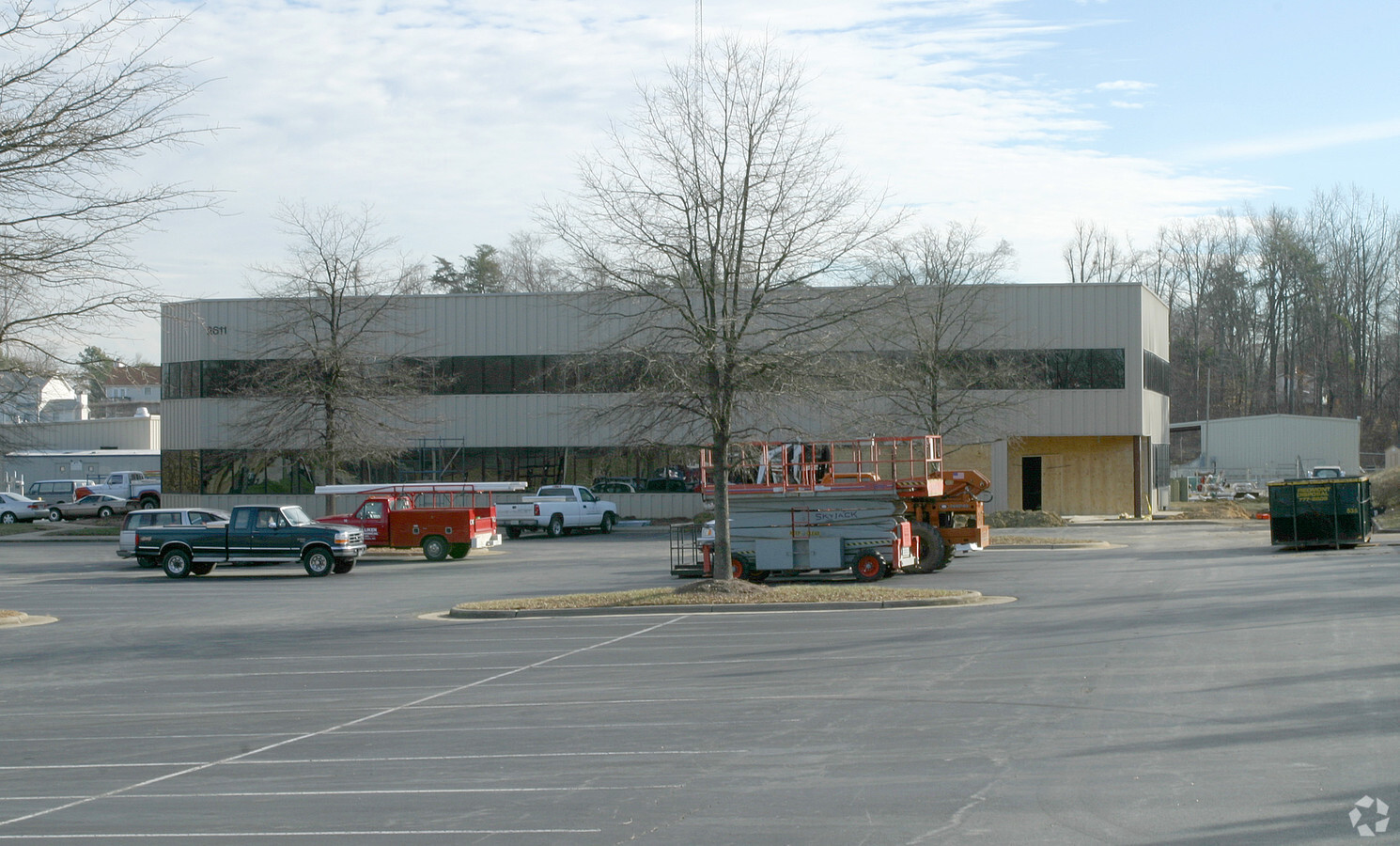
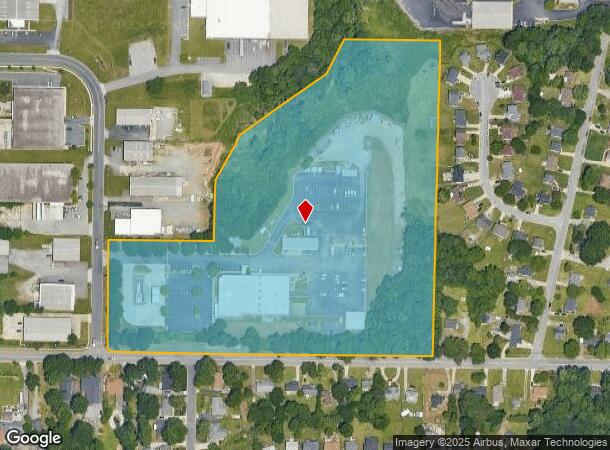
2611 Greengate Dr, Greensboro, NC 27406

NEARBY LISTINGS FOR SALE OR LEASE
Property Detail
2611 Greengate Dr
Greensboro-High Point, NC
Old Stone Bk
0051954
16.78AC 8 PB 75-109 OLD STONE BK
Industrialgeneral
Guilford
AE
North Carolina
3710786200J
24
0
16.78 AC
2023
South Greensboro
012804
Greensboro/Winston-Salem
40,776 SF
DEMOGRAPHICS near 2611 Greengate Dr
1 Mile
3 Mile
5 Mile
2024 Total Population
7,663
60,122
142,768
2029 Population
7,549
59,994
142,795
Pop Growth 2024-2029
(1.49%)
(0.21%)
+ 0.02%
Average Age
37
37
36
2024 Total Households
3,295
23,476
54,570
HH Growth 2024-2029
(1.49%)
(0.18%)
+ 0.15%
Median Household Inc
$50,080
$43,273
$46,717
Avg Household Size
2.30
2.40
2.30
2024 Avg HH Vehicles
2.00
2.00
2.00
Median Home Value
$116,415
$123,806
$158,222
Median Year Built
1984
1978
1976
Nearby Places
- Restaurants
- Banks
- Shops
- Fitness
- Groceries
PUBLIC TRANSPORTATION
COMMUTER RAIL
Greensboro Station (Piedmont - North Carolina by Train (NC Train))
DRIVE
WALK
Distance
Greensboro Station (Piedmont - North Carolina by Train (NC Train))
7 min
3.6 mi
AIRPORT
Piedmont Triad International
DRIVE
WALK
Distance
Piedmont Triad International
22 min
11.7 mi
Freight Ports
Port of Wilmington
DRIVE
WALK
Distance
Port of Wilmington
242 min
210.8 mi
Nearby Properties
Address
Land Use
TOTAL SIZE
Lot Size
Zoning
Address
Land Use
TOTAL SIZE
Lot Size
Zoning
1,864,781 SF
96.17 AC
PI
Address
Land Use
TOTAL SIZE
Lot Size
Zoning
671,937 SF
44.01 AC
PI
Address
Land Use
TOTAL SIZE
Lot Size
Zoning
733,612 SF
19.38 AC
PI
Address
Land Use
TOTAL SIZE
Lot Size
Zoning
957,290 SF
18.71 AC
C-H
Address
Land Use
TOTAL SIZE
Lot Size
Zoning
570,402 SF
33.42 AC
CU-RM-18
Address
Land Use
TOTAL SIZE
Lot Size
Zoning
446,318 SF
125.67 AC
LI
Address
Land Use
TOTAL SIZE
Lot Size
Zoning
412,479 SF
19.68 AC
CD-RM-26
Address
Land Use
TOTAL SIZE
Lot Size
Zoning
291,464 SF
17.51 AC
PI
Address
Land Use
TOTAL SIZE
Lot Size
Zoning
252,351 SF
9.48 AC
RM-18
Address
Land Use
TOTAL SIZE
Lot Size
Zoning
236,374 SF
7.69 AC
CB
Address
Land Use
TOTAL SIZE
Lot Size
Zoning
231,863 SF
7.96 AC
CD-PDI
Address
Land Use
TOTAL SIZE
Lot Size
Zoning
310,758 SF
63.58 AC
PI
Address
Land Use
TOTAL SIZE
Lot Size
Zoning
182,499 SF
6.74 AC
O
Address
Land Use
TOTAL SIZE
Lot Size
Zoning
300,901 SF
20.39 AC
R-3
Address
Land Use
TOTAL SIZE
Lot Size
Zoning
280,200 SF
19.28 AC
CU-RM-12
Address
Land Use
TOTAL SIZE
Lot Size
Zoning
234,712 SF
13 AC
PI
Address
Land Use
TOTAL SIZE
Lot Size
Zoning
116,713 SF
4.53 AC
C-M
Address
Land Use
TOTAL SIZE
Lot Size
Zoning
582,543 SF
47.07 AC
C-M
Address
Land Use
TOTAL SIZE
Lot Size
Zoning
250,084 SF
5.46 AC
PI
Address
Land Use
TOTAL SIZE
Lot Size
Zoning
104,984 SF
1.97 AC
C-M
Address
Land Use
TOTAL SIZE
Lot Size
Zoning
109,706 SF
1.56 AC
CB
Address
Land Use
TOTAL SIZE
Lot Size
Zoning
104,984 SF
3.18 AC
C-M
Address
Land Use
TOTAL SIZE
Lot Size
Zoning
336,760 SF
55.13 AC
LI
Address
Land Use
TOTAL SIZE
Lot Size
Zoning
201,999 SF
22.18 AC
CU-SC
Address
Land Use
TOTAL SIZE
Lot Size
Zoning
188,976 SF
41.46 AC
R-5
Address
Land Use
TOTAL SIZE
Lot Size
Zoning
83,667 SF
1.04 AC
CD-CB
Address
Land Use
TOTAL SIZE
Lot Size
Zoning
252,769 SF
21.98 AC
RM-12
Address
Land Use
TOTAL SIZE
Lot Size
Zoning
168,572 SF
16.57 AC
LI
Address
Land Use
TOTAL SIZE
Lot Size
Zoning
223,912 SF
23.25 AC
O
Address
Land Use
TOTAL SIZE
Lot Size
Zoning
90,450 SF
3.15 AC
C-M
The World's #1 Commercial Real Estate Marketplace
Connect with us
© 2025 CoStar Group
The information above has been obtained from sources believed reliable. While we do not doubt its accuracy we have not verified it and make no guarantee, warranty or representation about it. It is your responsibility to independently confirm its accuracy and completeness. Any projections, opinions, assumptions, or estimates used are for example only and do not represent the current or future performance of the property. The value of this transaction to you depends on tax and other factors which should be evaluated by your tax, financial, and legal advisors. You and your advisors should conduct a careful, independent investigation of the property to determine to your satisfaction the suitability of the property for your needs.