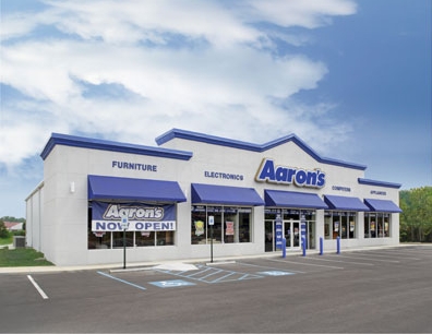
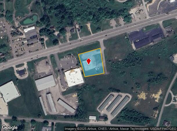
Property Record
2620 Maysville Pike, Zanesville, OH 43701
NEARBY LISTINGS FOR SALE OR LEASE
Property Detail
2620 Maysville Pike
Commercialnec
R 14 TP 15 SEC 2 N E W 1.27A
X
Muskingum
39119C0295G
Ohio
2023
1.27 AC
2023
Other Market Areas
912300
Zanesville, OH
8,136 SF
62-72-03-07-013
DEMOGRAPHICS near 2620 Maysville Pike
1 Mile
3 Mile
5 Mile
2024 Total Population
1,077
5,626
23,638
2029 Population
1,082
5,658
23,790
Pop Growth 2024-2029
+ 0.46%
+ 0.57%
+ 0.64%
Average Age
41
42
40
2024 Total Households
424
2,293
9,628
HH Growth 2024-2029
+ 0.47%
+ 0.57%
+ 0.62%
Median Household Inc
$51,695
$47,536
$40,754
Avg Household Size
2.50
2.40
2.40
2024 Avg HH Vehicles
2.00
2.00
2.00
Median Home Value
$139,835
$132,286
$96,986
Median Year Built
1974
1971
1958
Nearby Places
- Restaurants
- Banks
- Shops
- Fitness
- Groceries
Nearby Properties
Address
Land Use
TOTAL SIZE
Lot Size
Zoning
Address
Land Use
TOTAL SIZE
Lot Size
Zoning
12,480 SF
43.22 AC
Address
Land Use
TOTAL SIZE
Lot Size
Zoning
74,956 SF
10.45 AC
RS5
Address
Land Use
TOTAL SIZE
Lot Size
Zoning
150,499 SF
29.64 AC
Address
Land Use
TOTAL SIZE
Lot Size
Zoning
6,344 SF
19.56 AC
Address
Land Use
TOTAL SIZE
Lot Size
Zoning
184,623 SF
21.08 AC
Address
Land Use
TOTAL SIZE
Lot Size
Zoning
61,732 SF
18.46 AC
Address
Land Use
TOTAL SIZE
Lot Size
Zoning
6,662 SF
13.02 AC
I1
Address
Land Use
TOTAL SIZE
Lot Size
Zoning
3.37 AC
I1
Address
Land Use
TOTAL SIZE
Lot Size
Zoning
54,300 SF
7.47 AC
Address
Land Use
TOTAL SIZE
Lot Size
Zoning
98.11 AC
Address
Land Use
TOTAL SIZE
Lot Size
Zoning
5,404 SF
15.25 AC
RM1
Address
Land Use
TOTAL SIZE
Lot Size
Zoning
12,720 SF
5.24 AC
Address
Land Use
TOTAL SIZE
Lot Size
Zoning
16,109 SF
3.75 AC
Address
Land Use
TOTAL SIZE
Lot Size
Zoning
96,273 SF
6.41 AC
Address
Land Use
TOTAL SIZE
Lot Size
Zoning
960 SF
20.25 AC
I1
Address
Land Use
TOTAL SIZE
Lot Size
Zoning
38,732 SF
0.11 AC
RS5
Address
Land Use
TOTAL SIZE
Lot Size
Zoning
40,064 SF
6.55 AC
Address
Land Use
TOTAL SIZE
Lot Size
Zoning
6,877 SF
12.18 AC
RM1
Address
Land Use
TOTAL SIZE
Lot Size
Zoning
49,366 SF
1.67 AC
I1
Address
Land Use
TOTAL SIZE
Lot Size
Zoning
32,204 SF
1.15 AC
Address
Land Use
TOTAL SIZE
Lot Size
Zoning
12,160 SF
1.70 AC
RS5
Address
Land Use
TOTAL SIZE
Lot Size
Zoning
2.56 AC
Address
Land Use
TOTAL SIZE
Lot Size
Zoning
18,000 SF
3.21 AC
Address
Land Use
TOTAL SIZE
Lot Size
Zoning
15,056 SF
4 AC
Address
Land Use
TOTAL SIZE
Lot Size
Zoning
37,709 SF
7.85 AC
Address
Land Use
TOTAL SIZE
Lot Size
Zoning
71,070 SF
7.31 AC
Address
Land Use
TOTAL SIZE
Lot Size
Zoning
15,418 SF
1.01 AC
Address
Land Use
TOTAL SIZE
Lot Size
Zoning
24,140 SF
2.56 AC
Address
Land Use
TOTAL SIZE
Lot Size
Zoning
18,609 SF
1 AC
Address
Land Use
TOTAL SIZE
Lot Size
Zoning
37,048 SF
0.17 AC
The World's #1 Commercial Real Estate Marketplace
Connect with us
© 2025 CoStar Group
The information above has been obtained from sources believed reliable. While we do not doubt its accuracy we have not verified it and make no guarantee, warranty or representation about it. It is your responsibility to independently confirm its accuracy and completeness. Any projections, opinions, assumptions, or estimates used are for example only and do not represent the current or future performance of the property. The value of this transaction to you depends on tax and other factors which should be evaluated by your tax, financial, and legal advisors. You and your advisors should conduct a careful, independent investigation of the property to determine to your satisfaction the suitability of the property for your needs.