Property Record
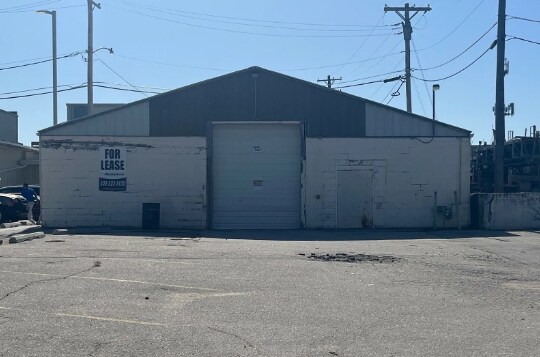
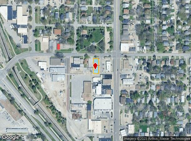
2625 Randolph St, Lincoln, NE 68510
Current Lease Availabilities
NEARBY LISTINGS FOR SALE OR LEASE
Property Detail
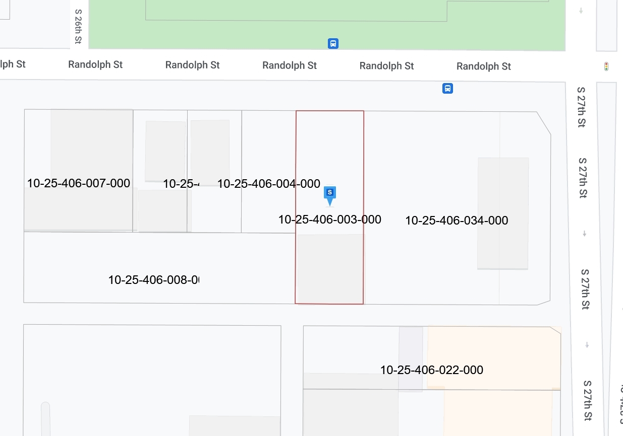
2625 Randolph St
Lincoln, NE
Houtz Place
10-25-406-003-000
HOUTZ PLACE, BLOCK 1, LOT 4
Commercialnec
Lancaster
X
Nebraska
31109C0316F
4
2023
0.16 AC
2023
East
001400
Lincoln
2,400 SF
DEMOGRAPHICS near 2625 Randolph St
1 Mile
3 Mile
5 Mile
2024 Total Population
26,557
116,789
244,974
2029 Population
27,562
121,157
253,680
Pop Growth 2024-2029
+ 3.78%
+ 3.74%
+ 3.55%
Average Age
34
36
38
2024 Total Households
11,371
50,112
102,393
HH Growth 2024-2029
+ 4.22%
+ 3.99%
+ 3.73%
Median Household Inc
$40,617
$49,343
$59,981
Avg Household Size
2.10
2.20
2.30
2024 Avg HH Vehicles
1.00
2.00
2.00
Median Home Value
$158,078
$179,768
$214,788
Median Year Built
1950
1962
1976
Nearby Places
- Restaurants
- Banks
- Shops
- Fitness
- Groceries
PUBLIC TRANSPORTATION
COMMUTER RAIL
Lincoln Amtrak Station (California Zephyr - Amtrak)
DRIVE
WALK
Distance
Lincoln Amtrak Station (California Zephyr - Amtrak)
5 min
2.4 mi
AIRPORT
Lincoln
DRIVE
WALK
Distance
Lincoln
13 min
6.8 mi
Freight Ports
Tulsa Port Of Catoosa
DRIVE
WALK
Distance
Tulsa Port Of Catoosa
469 min
391.1 mi
Nearby Properties
Address
Land Use
TOTAL SIZE
Lot Size
Zoning
Address
Land Use
TOTAL SIZE
Lot Size
Zoning
604,749 SF
20.55 AC
R2
Address
Land Use
TOTAL SIZE
Lot Size
Zoning
364,797 SF
25.06 AC
R1
Address
Land Use
TOTAL SIZE
Lot Size
Zoning
684,598 SF
21.16 AC
B3
Address
Land Use
TOTAL SIZE
Lot Size
Zoning
413,484 SF
44.25 AC
R6
Address
Land Use
TOTAL SIZE
Lot Size
Zoning
131,328 SF
2.07 AC
P
Address
Land Use
TOTAL SIZE
Lot Size
Zoning
329,069 SF
30 AC
R6
Address
Land Use
TOTAL SIZE
Lot Size
Zoning
182,668 SF
2.07 AC
B4
Address
Land Use
TOTAL SIZE
Lot Size
Zoning
72,047 SF
1.03 AC
B4
Address
Land Use
TOTAL SIZE
Lot Size
Zoning
216,894 SF
1.46 AC
B4
Address
Land Use
TOTAL SIZE
Lot Size
Zoning
179,447 SF
7.85 AC
R6
Address
Land Use
TOTAL SIZE
Lot Size
Zoning
287,193 SF
6.62 AC
B4
Address
Land Use
TOTAL SIZE
Lot Size
Zoning
101,990 SF
5.38 AC
R4
Address
Land Use
TOTAL SIZE
Lot Size
Zoning
71,046 SF
23.72 AC
R5
Address
Land Use
TOTAL SIZE
Lot Size
Zoning
65,430 SF
1.12 AC
B4
Address
Land Use
TOTAL SIZE
Lot Size
Zoning
217,115 SF
0.89 AC
B4
Address
Land Use
TOTAL SIZE
Lot Size
Zoning
37,240 SF
17.06 AC
NULL
Address
Land Use
TOTAL SIZE
Lot Size
Zoning
36,751 SF
1.80 AC
B5
Address
Land Use
TOTAL SIZE
Lot Size
Zoning
189,854 SF
2.07 AC
P
Address
Land Use
TOTAL SIZE
Lot Size
Zoning
92,418 SF
0.79 AC
B4
Address
Land Use
TOTAL SIZE
Lot Size
Zoning
180,578 SF
1.32 AC
P
Address
Land Use
TOTAL SIZE
Lot Size
Zoning
189,948 SF
13.56 AC
R2
Address
Land Use
TOTAL SIZE
Lot Size
Zoning
43,276 SF
4.60 AC
R2
Address
Land Use
TOTAL SIZE
Lot Size
Zoning
62,499 SF
5.77 AC
R4
Address
Land Use
TOTAL SIZE
Lot Size
Zoning
56,867 SF
22.10 AC
NULL
Address
Land Use
TOTAL SIZE
Lot Size
Zoning
53,419 SF
0.43 AC
B4
Address
Land Use
TOTAL SIZE
Lot Size
Zoning
119,655 SF
2.28 AC
B4
Address
Land Use
TOTAL SIZE
Lot Size
Zoning
134,835 SF
1.22 AC
B4
Address
Land Use
TOTAL SIZE
Lot Size
Zoning
23,881 SF
0.80 AC
B4
Address
Land Use
TOTAL SIZE
Lot Size
Zoning
63,003 SF
1.22 AC
O3
Address
Land Use
TOTAL SIZE
Lot Size
Zoning
47,017 SF
0.92 AC
B4
The World's #1 Commercial Real Estate Marketplace
Connect with us
© 2025 CoStar Group
The information above has been obtained from sources believed reliable. While we do not doubt its accuracy we have not verified it and make no guarantee, warranty or representation about it. It is your responsibility to independently confirm its accuracy and completeness. Any projections, opinions, assumptions, or estimates used are for example only and do not represent the current or future performance of the property. The value of this transaction to you depends on tax and other factors which should be evaluated by your tax, financial, and legal advisors. You and your advisors should conduct a careful, independent investigation of the property to determine to your satisfaction the suitability of the property for your needs.