Property Record
2625 W 5Th St, Jacksonville, FL 32254
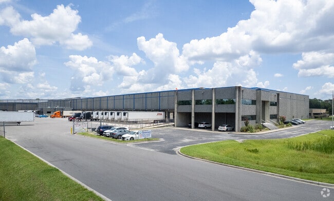


Property Detail
2625 W 5Th St
050309-0000
09-2S-26E 12.41 PT NW1/4 RECD O/R BKS 6290-1693, 1696,6352-2089
Warehouse
Duval
IL
Florida
B and X Area of moderate flood hazard, usually the area between the limits of the 100-year and 500-year floods.
11.81 AC
2025
West Side
2026
Jacksonville (Florida)
002701
Jacksonville, FL
267,290 SF
NEARBY LISTINGS FOR SALE OR LEASE
DEMOGRAPHICS near 2625 W 5Th St
1 mile
3 mile
5 mile
2025 Total Population
10,098
89,302
198,647
2030 Population
10,774
95,908
213,319
Pop Growth 2025-2030
+ 6.69%
+ 7.40%
+ 7.39%
Average Age
38
39
39
2025 Total Households
3,796
37,638
82,966
HH Growth 2025-2030
+ 6.95%
+ 7.70%
+ 7.78%
Median Household Inc
$33,760
$39,044
$44,004
Avg Household Size
2.50
2.30
2.30
2025 Avg HH Vehicles
1.00
1.00
1.00
Median Home Value
$83,743
$166,026
$197,153
Median Year Built
1962
1960
1962
Nearby Places
Map Layers
Map Styles
 Street
 Aerial
Layers
 Traffic
 Biking
Places
Listings with unknown addresses are not visible on the map
- Restaurants
- Banks
- Shops
- Fitness
- Groceries
PUBLIC TRANSPORTATION
COMMUTER RAIL
Jacksonville (Silver Meteor - Amtrak, Silver Star - Amtrak)
Drive
Walk
Distance
Jacksonville (Silver Meteor - Amtrak, Silver Star - Amtrak)
9 min
3.9 mi
AIRPORT
Jacksonville International
Drive
Walk
Distance
Jacksonville International
29 min
17.3 mi
Freight Ports
Jacksonville Port
Drive
Walk
Distance
Jacksonville Port
17 min
7.8 mi
Nearby Properties
Address
Land Use
TOTAL SIZE
Lot Size
Zoning
Address
Land Use
TOTAL SIZE
Lot Size
Zoning
543,383 SF
7.87 AC
CCBD
Address
Land Use
TOTAL SIZE
Lot Size
Zoning
629,459 SF
10.33 AC
PUD
Address
Land Use
TOTAL SIZE
Lot Size
Zoning
705,940 SF
25.12 AC
PBF-1
Address
Land Use
TOTAL SIZE
Lot Size
Zoning
407,122 SF
4.50 AC
CCBD
Address
Land Use
TOTAL SIZE
Lot Size
Zoning
187,278 SF
1.71 AC
CCBD
Address
Land Use
TOTAL SIZE
Lot Size
Zoning
313,472 SF
35.44 AC
CCBD
Address
Land Use
TOTAL SIZE
Lot Size
Zoning
355,967 SF
8.98 AC
PUD
Address
Land Use
TOTAL SIZE
Lot Size
Zoning
700,443 SF
8 AC
CCBD
Address
Land Use
TOTAL SIZE
Lot Size
Zoning
264,277 SF
2.07 AC
CCBD
Address
Land Use
TOTAL SIZE
Lot Size
Zoning
299,055 SF
18.93 AC
CCBD
Address
Land Use
TOTAL SIZE
Lot Size
Zoning
290,975 SF
4.49 AC
PUD
Address
Land Use
TOTAL SIZE
Lot Size
Zoning
212,152 SF
8.17 AC
CCBD
Address
Land Use
TOTAL SIZE
Lot Size
Zoning
465,664 SF
21.27 AC
IL
Address
Land Use
TOTAL SIZE
Lot Size
Zoning
163,471 SF
7.85 AC
PBF-2
Address
Land Use
TOTAL SIZE
Lot Size
Zoning
888,083 SF
46.65 AC
IL
Address
Land Use
TOTAL SIZE
Lot Size
Zoning
352,439 SF
3.40 AC
CCBD
Address
Land Use
TOTAL SIZE
Lot Size
Zoning
225,440 SF
4.68 AC
PUD
Address
Land Use
TOTAL SIZE
Lot Size
Zoning
222,138 SF
13.18 AC
IL
Address
Land Use
TOTAL SIZE
Lot Size
Zoning
255,405 SF
1.91 AC
PUD
Address
Land Use
TOTAL SIZE
Lot Size
Zoning
594,573 SF
27.69 AC
IL
Address
Land Use
TOTAL SIZE
Lot Size
Zoning
144,400 SF
10.32 AC
PBF-2
Address
Land Use
TOTAL SIZE
Lot Size
Zoning
216,810 SF
4.24 AC
CCBD
Address
Land Use
TOTAL SIZE
Lot Size
Zoning
255,048 SF
20.15 AC
IL
Address
Land Use
TOTAL SIZE
Lot Size
Zoning
77,356 SF
2.15 AC
PBF-2
Address
Land Use
TOTAL SIZE
Lot Size
Zoning
72,080 SF
4.19 AC
CCBD
Address
Land Use
TOTAL SIZE
Lot Size
Zoning
186,773 SF
9.77 AC
CCG-2
Address
Land Use
TOTAL SIZE
Lot Size
Zoning
100,600 SF
1.31 AC
PUD
Address
Land Use
TOTAL SIZE
Lot Size
Zoning
40,984 SF
2.33 AC
CCBD
Address
Land Use
TOTAL SIZE
Lot Size
Zoning
117,227 SF
14.32 AC
CCG-2
Address
Land Use
TOTAL SIZE
Lot Size
Zoning
317,474 SF
17.74 AC
IL
The World's #1 Commercial Real Estate Marketplace
Connect with us
© 2026 CoStar Group
The information above has been obtained from sources believed reliable. While we do not doubt its accuracy we have not verified it and make no guarantee, warranty or representation about it. It is your responsibility to independently confirm its accuracy and completeness. Any projections, opinions, assumptions, or estimates used are for example only and do not represent the current or future performance of the property. The value of this transaction to you depends on tax and other factors which should be evaluated by your tax, financial, and legal advisors. You and your advisors should conduct a careful, independent investigation of the property to determine to your satisfaction the suitability of the property for your needs.