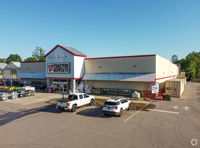
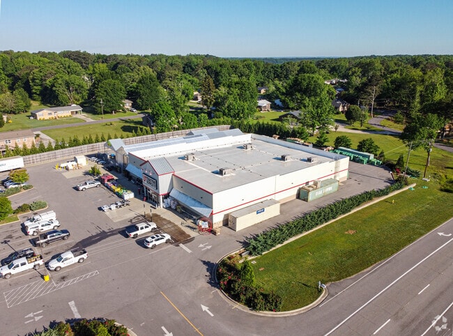
Property Record
2626 Decatur Hwy, Gardendale, AL 35071

NEARBY LISTINGS FOR SALE OR LEASE
Property Detail
2626 Decatur Hwy
Birmingham-Hoover, AL
Resur Of Lots 57, 58, 59, 60 &
07-00-35-1-004-008.003
LOT 1 RESUR OF LOTS 57, 58, 59, 60 & 61 GARDEN GROVE #3 239/72
Autorepair
Jefferson
X
Alabama
01073C0205H
1
2023
1.56 AC
2024
Fultondale
011704
Birmingham
19,246 SF
DEMOGRAPHICS near 2626 Decatur Hwy
1 Mile
3 Mile
5 Mile
2024 Total Population
1,636
9,471
25,930
2029 Population
1,583
9,166
25,123
Pop Growth 2024-2029
(3.24%)
(3.22%)
(3.11%)
Average Age
43
43
41
2024 Total Households
648
3,841
10,214
HH Growth 2024-2029
(3.40%)
(3.31%)
(3.22%)
Median Household Inc
$59,999
$66,064
$74,361
Avg Household Size
2.50
2.40
2.50
2024 Avg HH Vehicles
2.00
2.00
2.00
Median Home Value
$199,999
$201,293
$199,784
Median Year Built
1979
1980
1985
Nearby Places
Map Layers
Map Styles
 Street
 Aerial
- Restaurants
- Banks
- Shops
- Fitness
- Groceries
PUBLIC TRANSPORTATION
AIRPORT
Birmingham-Shuttlesworth International
DRIVE
WALK
Distance
Birmingham-Shuttlesworth International
26 min
19.7 mi
Freight Ports
Port of Mobile
DRIVE
WALK
Distance
Port of Mobile
295 min
269.5 mi
SALE & LEASE HISTORY
LISTING DATE
SALE/LEASE

Apr 20, 2017
For Sale
Nearby Properties
Address
Land Use
TOTAL SIZE
Lot Size
Zoning
Address
Land Use
TOTAL SIZE
Lot Size
Zoning
176,544 SF
17 AC
C-2
Address
Land Use
TOTAL SIZE
Lot Size
Zoning
161,736 SF
6.70 AC
C2
Address
Land Use
TOTAL SIZE
Lot Size
Zoning
62,430 SF
2.44 AC
C2
Address
Land Use
TOTAL SIZE
Lot Size
Zoning
3.22 AC
INST
Address
Land Use
TOTAL SIZE
Lot Size
Zoning
64,990 SF
4.97 AC
INST
Address
Land Use
TOTAL SIZE
Lot Size
Zoning
84,942 SF
11 AC
I1
Address
Land Use
TOTAL SIZE
Lot Size
Zoning
66,038 SF
3.74 AC
C2
Address
Land Use
TOTAL SIZE
Lot Size
Zoning
55,872 SF
5.20 AC
C2
Address
Land Use
TOTAL SIZE
Lot Size
Zoning
59,438 SF
5.10 AC
C2
Address
Land Use
TOTAL SIZE
Lot Size
Zoning
27,112 SF
3.82 AC
C2
Address
Land Use
TOTAL SIZE
Lot Size
Zoning
91,135 SF
4.47 AC
C2
Address
Land Use
TOTAL SIZE
Lot Size
Zoning
39,750 SF
6 AC
C2
Address
Land Use
TOTAL SIZE
Lot Size
Zoning
36,821 SF
3.60 AC
INST
Address
Land Use
TOTAL SIZE
Lot Size
Zoning
46,720 SF
2.59 AC
C2
Address
Land Use
TOTAL SIZE
Lot Size
Zoning
47,959 SF
3.50 AC
C2
Address
Land Use
TOTAL SIZE
Lot Size
Zoning
33,598 SF
5 AC
C2
Address
Land Use
TOTAL SIZE
Lot Size
Zoning
22,128 SF
5 AC
C-2
Address
Land Use
TOTAL SIZE
Lot Size
Zoning
13,023 SF
5.10 AC
C2
Address
Land Use
TOTAL SIZE
Lot Size
Zoning
10,077 SF
1.68 AC
C2
Address
Land Use
TOTAL SIZE
Lot Size
Zoning
5,419 SF
3 AC
C2
Address
Land Use
TOTAL SIZE
Lot Size
Zoning
16,488 SF
0.99 AC
C2
Address
Land Use
TOTAL SIZE
Lot Size
Zoning
4,268 SF
0.82 AC
C2
Address
Land Use
TOTAL SIZE
Lot Size
Zoning
17,200 SF
1.62 AC
C2
Address
Land Use
TOTAL SIZE
Lot Size
Zoning
20,614 SF
16 AC
A1-I
Address
Land Use
TOTAL SIZE
Lot Size
Zoning
11,480 SF
2.78 AC
B1
Address
Land Use
TOTAL SIZE
Lot Size
Zoning
21,224 SF
2.01 AC
R-4
Address
Land Use
TOTAL SIZE
Lot Size
Zoning
14,984 SF
2.10 AC
A1
Address
Land Use
TOTAL SIZE
Lot Size
Zoning
13,829 SF
1.52 AC
C2
Address
Land Use
TOTAL SIZE
Lot Size
Zoning
7,117 SF
2.45 AC
C2
The World's #1 Commercial Real Estate Marketplace
Connect with us
© 2026 CoStar Group
The information above has been obtained from sources believed reliable. While we do not doubt its accuracy we have not verified it and make no guarantee, warranty or representation about it. It is your responsibility to independently confirm its accuracy and completeness. Any projections, opinions, assumptions, or estimates used are for example only and do not represent the current or future performance of the property. The value of this transaction to you depends on tax and other factors which should be evaluated by your tax, financial, and legal advisors. You and your advisors should conduct a careful, independent investigation of the property to determine to your satisfaction the suitability of the property for your needs.