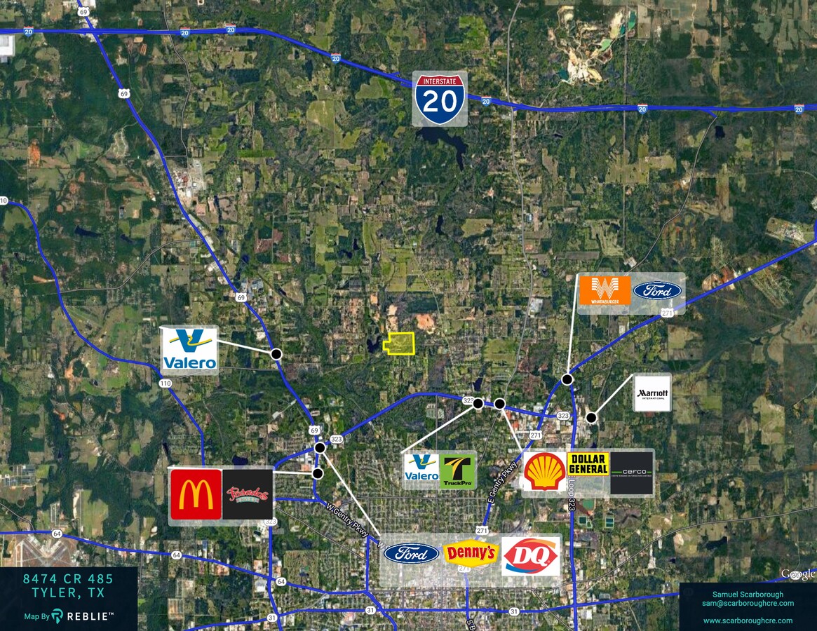
Property Record
8474 County Road 485, Tyler, TX 75706
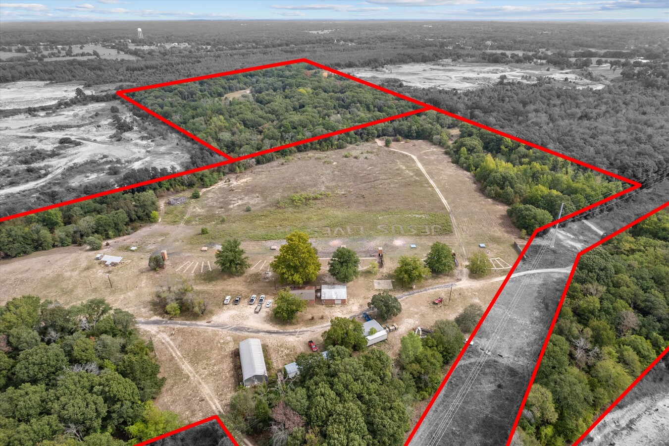

This Property Is For Sale
NEARBY LISTINGS FOR SALE OR LEASE
Property Detail
8474 County Road 485
Tyler, TX
A0072 T Burbridge
1-00000-0072-00-003001
ABST A0072 T BURBRIDGETRACT 3 (PT OF 54.255AC / SEE TR3.1) IMP ON 3.2
Ruralimprovednonresidential
Smith
A
Texas
48423C0245D
49.26 AC
2024
Tyler & Longview
2024
Other Market Areas
001605
DEMOGRAPHICS near 8474 County Road 485
1 Mile
3 Mile
5 Mile
2024 Total Population
987
22,432
57,100
2029 Population
1,097
24,480
62,333
Pop Growth 2024-2029
+ 11.14%
+ 9.13%
+ 9.16%
Average Age
34
35
35
2024 Total Households
306
7,409
19,180
HH Growth 2024-2029
+ 10.78%
+ 8.64%
+ 8.67%
Median Household Inc
$58,499
$47,514
$47,012
Avg Household Size
3.10
2.90
2.80
2024 Avg HH Vehicles
2.00
2.00
2.00
Median Home Value
$103,226
$96,243
$111,677
Median Year Built
1978
1967
1966
Nearby Places
- Restaurants
- Banks
- Shops
- Fitness
- Groceries
PUBLIC TRANSPORTATION
AIRPORT
Tyler Pounds Regional
DRIVE
WALK
Distance
Tyler Pounds Regional
20 min
9.8 mi
Freight Ports
Port of Shreveport
DRIVE
WALK
Distance
Port of Shreveport
122 min
106.2 mi
Nearby Properties
Address
Land Use
TOTAL SIZE
Lot Size
Zoning
Address
Land Use
TOTAL SIZE
Lot Size
Zoning
Address
Land Use
TOTAL SIZE
Lot Size
Zoning
229,190 SF
26 AC
Address
Land Use
TOTAL SIZE
Lot Size
Zoning
25.54 AC
INT
Address
Land Use
TOTAL SIZE
Lot Size
Zoning
520,081 SF
24.62 AC
M2
Address
Land Use
TOTAL SIZE
Lot Size
Zoning
3,222 SF
7.43 AC
RMF
Address
Land Use
TOTAL SIZE
Lot Size
Zoning
111,048 SF
10 AC
RMF
Address
Land Use
TOTAL SIZE
Lot Size
Zoning
1,375 SF
8.50 AC
RMF
Address
Land Use
TOTAL SIZE
Lot Size
Zoning
15.67 AC
R1A
Address
Land Use
TOTAL SIZE
Lot Size
Zoning
95,278 SF
4.60 AC
Address
Land Use
TOTAL SIZE
Lot Size
Zoning
171,588 SF
16.21 AC
Address
Land Use
TOTAL SIZE
Lot Size
Zoning
3,312 SF
10.58 AC
Address
Land Use
TOTAL SIZE
Lot Size
Zoning
72,000 SF
24.16 AC
Address
Land Use
TOTAL SIZE
Lot Size
Zoning
3,319 SF
18 AC
Address
Land Use
TOTAL SIZE
Lot Size
Zoning
20,597 SF
3.28 AC
Address
Land Use
TOTAL SIZE
Lot Size
Zoning
25.81 AC
R1B
Address
Land Use
TOTAL SIZE
Lot Size
Zoning
1,648.96 AC
Address
Land Use
TOTAL SIZE
Lot Size
Zoning
Address
Land Use
TOTAL SIZE
Lot Size
Zoning
18,577 SF
8.60 AC
M1
Address
Land Use
TOTAL SIZE
Lot Size
Zoning
1,045 AC
Address
Land Use
TOTAL SIZE
Lot Size
Zoning
57,576 SF
5.96 AC
M1
Address
Land Use
TOTAL SIZE
Lot Size
Zoning
10.19 AC
R2
Address
Land Use
TOTAL SIZE
Lot Size
Zoning
24,912 SF
3.60 AC
RMF
Address
Land Use
TOTAL SIZE
Lot Size
Zoning
186,925 SF
6.11 AC
M2
Address
Land Use
TOTAL SIZE
Lot Size
Zoning
6.82 AC
R1B
Address
Land Use
TOTAL SIZE
Lot Size
Zoning
78,957 SF
13.58 AC
M1
Address
Land Use
TOTAL SIZE
Lot Size
Zoning
7,716 SF
1.69 AC
M1
Address
Land Use
TOTAL SIZE
Lot Size
Zoning
60,000 SF
88.29 AC
Address
Land Use
TOTAL SIZE
Lot Size
Zoning
8.68 AC
R1A
Address
Land Use
TOTAL SIZE
Lot Size
Zoning
50,907 SF
4.34 AC
M2
Address
Land Use
TOTAL SIZE
Lot Size
Zoning
76,557 SF
4.92 AC
C4
The World's #1 Commercial Real Estate Marketplace
Connect with us
© 2025 CoStar Group
The information above has been obtained from sources believed reliable. While we do not doubt its accuracy we have not verified it and make no guarantee, warranty or representation about it. It is your responsibility to independently confirm its accuracy and completeness. Any projections, opinions, assumptions, or estimates used are for example only and do not represent the current or future performance of the property. The value of this transaction to you depends on tax and other factors which should be evaluated by your tax, financial, and legal advisors. You and your advisors should conduct a careful, independent investigation of the property to determine to your satisfaction the suitability of the property for your needs.