Property Record
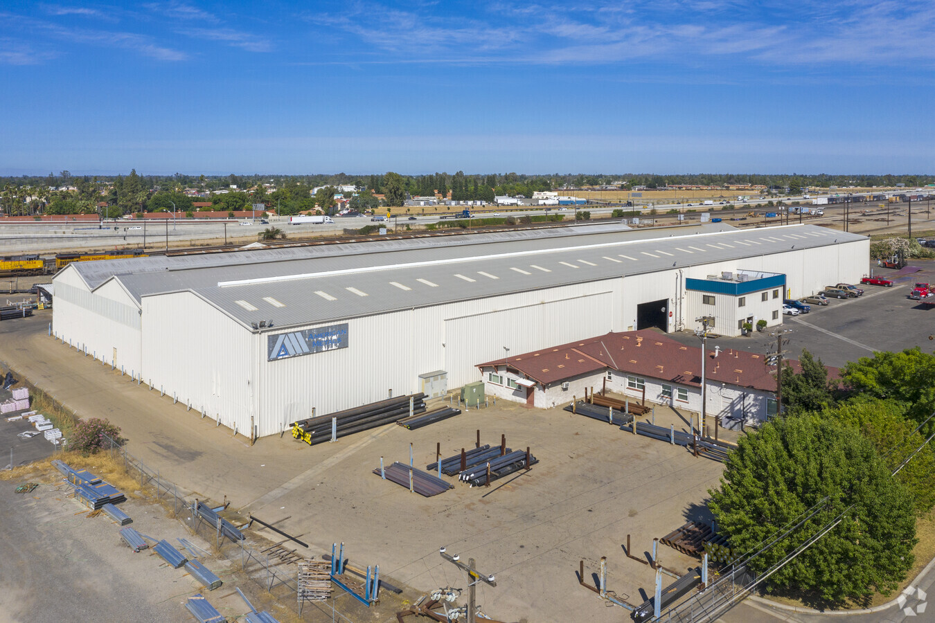
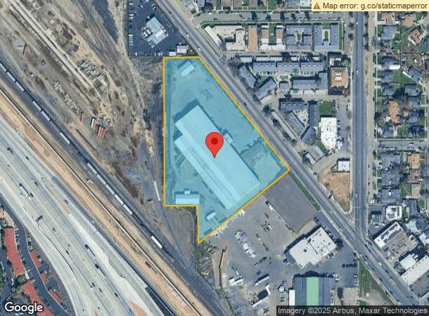
2655 N Weber Ave, Fresno, CA 93705
NEARBY LISTINGS FOR SALE OR LEASE
Property Detail
2655 N Weber Ave
Fresno, CA
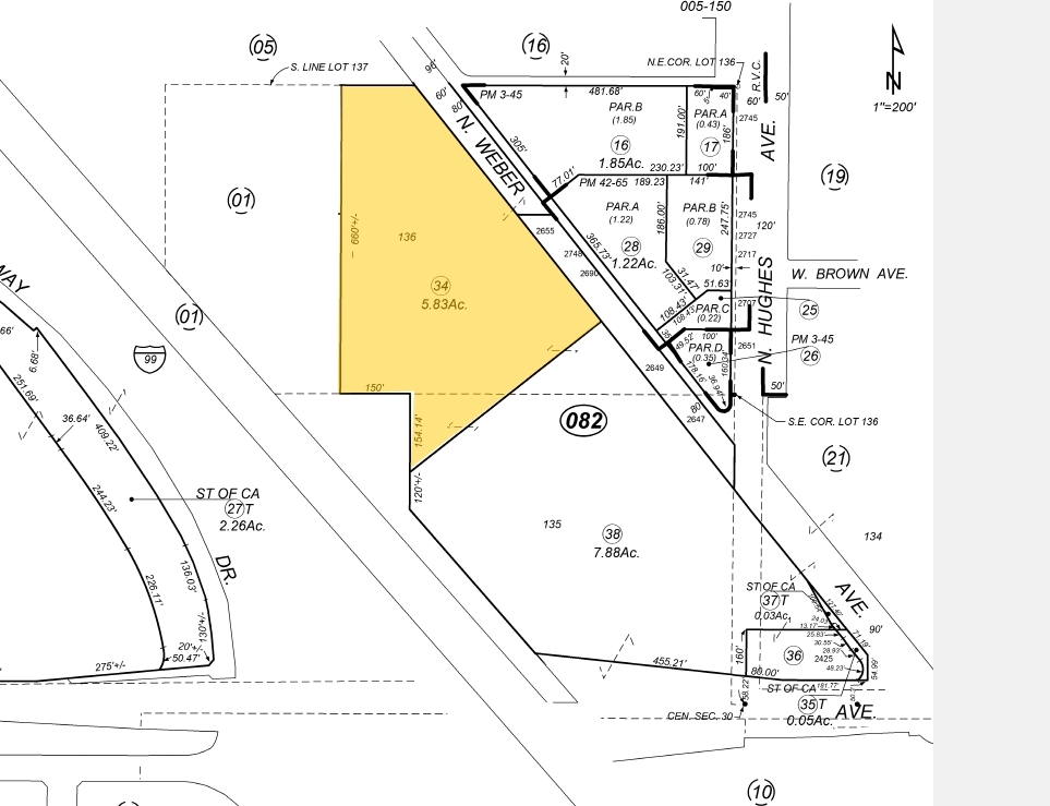
Roedings Villa Colon
442-082-34
5.83 AC IN LOTS 135 & 136 ROEDINGS VILLA COL
Lightindustrial
Fresno
X
California
06019C1565H
136
2023
5.83 AC
2023
Northwest Fresno
004205
Fresno
91,980 SF
DEMOGRAPHICS near 2655 N Weber Ave
1 Mile
3 Mile
5 Mile
2024 Total Population
21,863
132,368
329,227
2029 Population
22,272
134,758
335,802
Pop Growth 2024-2029
+ 1.87%
+ 1.81%
+ 2.00%
Average Age
33
35
36
2024 Total Households
6,766
44,095
108,302
HH Growth 2024-2029
+ 1.83%
+ 1.82%
+ 2.00%
Median Household Inc
$38,943
$54,778
$54,501
Avg Household Size
3.10
2.90
2.90
2024 Avg HH Vehicles
2.00
2.00
2.00
Median Home Value
$218,497
$272,065
$289,425
Median Year Built
1967
1969
1972
Nearby Places
- Restaurants
- Banks
- Shops
- Fitness
- Groceries
PUBLIC TRANSPORTATION
COMMUTER RAIL
Fresno (San Joaquins - Amtrak)
DRIVE
WALK
Distance
Fresno (San Joaquins - Amtrak)
8 min
5.5 mi
AIRPORT
Fresno Yosemite International
DRIVE
WALK
Distance
Fresno Yosemite International
13 min
6.8 mi
Freight Ports
Port of Stockton
DRIVE
WALK
Distance
Port of Stockton
146 min
123.8 mi
Nearby Properties
Address
Land Use
TOTAL SIZE
Lot Size
Zoning
Address
Land Use
TOTAL SIZE
Lot Size
Zoning
477,820 SF
18.78 AC
RA
Address
Land Use
TOTAL SIZE
Lot Size
Zoning
423,568 SF
32.25 AC
R2
Address
Land Use
TOTAL SIZE
Lot Size
Zoning
234,370 SF
23 AC
SPLIT
Address
Land Use
TOTAL SIZE
Lot Size
Zoning
178,900 SF
11.68 AC
CP
Address
Land Use
TOTAL SIZE
Lot Size
Zoning
232,183 SF
18.32 AC
R2A
Address
Land Use
TOTAL SIZE
Lot Size
Zoning
669,447 SF
0.01 AC
C3
Address
Land Use
TOTAL SIZE
Lot Size
Zoning
159,822 SF
9.67 AC
R2
Address
Land Use
TOTAL SIZE
Lot Size
Zoning
51,363 SF
3.14 AC
CG
Address
Land Use
TOTAL SIZE
Lot Size
Zoning
110,341 SF
5.45 AC
R3
Address
Land Use
TOTAL SIZE
Lot Size
Zoning
191,136 SF
12.12 AC
R2
Address
Land Use
TOTAL SIZE
Lot Size
Zoning
108,017 SF
2.91 AC
CM
Address
Land Use
TOTAL SIZE
Lot Size
Zoning
207,808 SF
17.59 AC
CM
Address
Land Use
TOTAL SIZE
Lot Size
Zoning
145,783 SF
9.22 AC
R2
Address
Land Use
TOTAL SIZE
Lot Size
Zoning
182,722 SF
13.29 AC
R2
Address
Land Use
TOTAL SIZE
Lot Size
Zoning
56,490 SF
1.93 AC
CP
Address
Land Use
TOTAL SIZE
Lot Size
Zoning
127,394 SF
8.87 AC
R2
Address
Land Use
TOTAL SIZE
Lot Size
Zoning
83,622 SF
3.98 AC
M1
Address
Land Use
TOTAL SIZE
Lot Size
Zoning
108,795 SF
7.32 AC
R2
Address
Land Use
TOTAL SIZE
Lot Size
Zoning
64,428 SF
1.80 AC
CP
Address
Land Use
TOTAL SIZE
Lot Size
Zoning
92,096 SF
0.01 AC
C3
Address
Land Use
TOTAL SIZE
Lot Size
Zoning
102,160 SF
8.45 AC
SPLIT
Address
Land Use
TOTAL SIZE
Lot Size
Zoning
103,088 SF
5.41 AC
R3
Address
Land Use
TOTAL SIZE
Lot Size
Zoning
104,819 SF
8.50 AC
C2
Address
Land Use
TOTAL SIZE
Lot Size
Zoning
84,050 SF
6.84 AC
R3
Address
Land Use
TOTAL SIZE
Lot Size
Zoning
105,055 SF
3.95 AC
RMX
Address
Land Use
TOTAL SIZE
Lot Size
Zoning
111,104 SF
7.96 AC
R2A
Address
Land Use
TOTAL SIZE
Lot Size
Zoning
46,838 SF
1.47 AC
CP
Address
Land Use
TOTAL SIZE
Lot Size
Zoning
82,400 SF
6.01 AC
C2
Address
Land Use
TOTAL SIZE
Lot Size
Zoning
96,077 SF
8.29 AC
C3
Address
Land Use
TOTAL SIZE
Lot Size
Zoning
72,277 SF
5.50 AC
M1
The World's #1 Commercial Real Estate Marketplace
Connect with us
© 2025 CoStar Group
The information above has been obtained from sources believed reliable. While we do not doubt its accuracy we have not verified it and make no guarantee, warranty or representation about it. It is your responsibility to independently confirm its accuracy and completeness. Any projections, opinions, assumptions, or estimates used are for example only and do not represent the current or future performance of the property. The value of this transaction to you depends on tax and other factors which should be evaluated by your tax, financial, and legal advisors. You and your advisors should conduct a careful, independent investigation of the property to determine to your satisfaction the suitability of the property for your needs.