Property Record
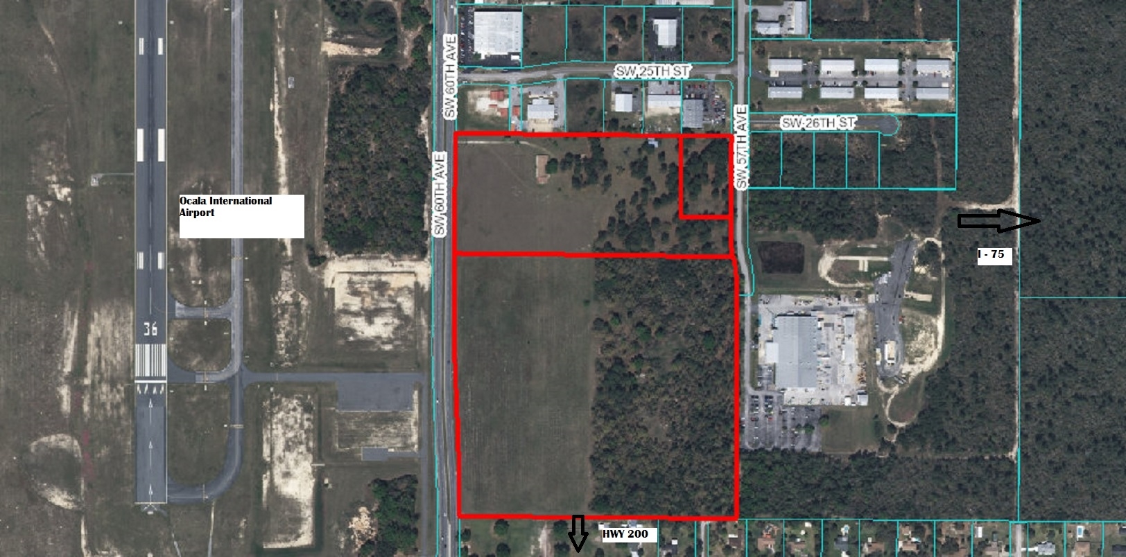
2667 Sw 60Th Ave, Ocala, FL 34474
NEARBY LISTINGS FOR SALE OR LEASE
Property Detail
2667 Sw 60Th Ave
23817-000-00
SEC 28 TWP 15 RGE 21 COM AT THE NW COR OF SEC 28 TH S 89-57-29 E 15 FT TO THE POB TH S 00-00-08 E 1155.25 FT TH S 89-57-29 E 1319.13 FT TH N 00-04-12 E 1155.25 FT TH N 89-57-29 W 1320.59 FT TO THE POB EXC COM AT NW COR OF SEC 28 TH S 89-57-29 E 15 FT
Warehouse
Marion
X
Florida
12083C0512E
14.27 AC
2023
Outlying Marion County
2023
Ocala
002507
Ocala, FL
334,466 SF
DEMOGRAPHICS near 2667 Sw 60Th Ave
1 Mile
3 Mile
5 Mile
2024 Total Population
2,751
23,988
54,291
2029 Population
3,057
27,079
61,580
Pop Growth 2024-2029
+ 11.12%
+ 12.89%
+ 13.43%
Average Age
38
41
46
2024 Total Households
1,171
9,300
22,873
HH Growth 2024-2029
+ 10.93%
+ 13.09%
+ 13.50%
Median Household Inc
$56,435
$55,598
$54,165
Avg Household Size
2.30
2.30
2.20
2024 Avg HH Vehicles
1.00
2.00
1.00
Median Home Value
$165,789
$205,344
$229,929
Median Year Built
1990
1992
1995
Nearby Places
- Restaurants
- Banks
- Shops
- Fitness
- Groceries
SALE & LEASE HISTORY
LISTING DATE
SALE/LEASE

Sep 24, 2016
For Sale
Dec 01, 2016
For Sale
Aug 09, 2017
For Sale
Nearby Properties
Address
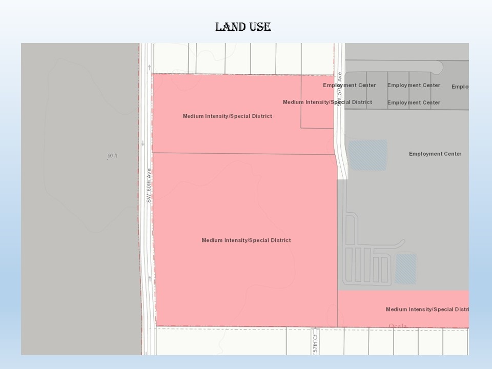
Land Use
TOTAL SIZE
Lot Size
Zoning
Address
Land Use
TOTAL SIZE
Lot Size
Zoning
2,015,469 SF
169.30 AC
M1
Address
Land Use
TOTAL SIZE
Lot Size
Zoning
156,201 SF
36.77 AC
INST
Address
Land Use
TOTAL SIZE
Lot Size
Zoning
493,261 SF
126.01 AC
R3
Address
Land Use
TOTAL SIZE
Lot Size
Zoning
283,913 SF
24.22 AC
B2
Address
Land Use
TOTAL SIZE
Lot Size
Zoning
446,764 SF
138.06 AC
GU
Address
Land Use
TOTAL SIZE
Lot Size
Zoning
612,196 SF
50.06 AC
M1
Address
Land Use
TOTAL SIZE
Lot Size
Zoning
164,363 SF
16.51 AC
R3
Address
Land Use
TOTAL SIZE
Lot Size
Zoning
422,264 SF
40.87 AC
SC
Address
Land Use
TOTAL SIZE
Lot Size
Zoning
324,262 SF
48.94 AC
SC
Address
Land Use
TOTAL SIZE
Lot Size
Zoning
154,675 SF
23.62 AC
PD09
Address
Land Use
TOTAL SIZE
Lot Size
Zoning
322,193 SF
70.13 AC
INST
Address
Land Use
TOTAL SIZE
Lot Size
Zoning
444,381 SF
60 AC
M1
Address
Land Use
TOTAL SIZE
Lot Size
Zoning
189,662 SF
25.54 AC
B2
Address
Land Use
TOTAL SIZE
Lot Size
Zoning
152,355 SF
973.50 AC
GU
Address
Land Use
TOTAL SIZE
Lot Size
Zoning
403,023 SF
47.47 AC
M1
Address
Land Use
TOTAL SIZE
Lot Size
Zoning
110,226 SF
19.56 AC
PD09
Address
Land Use
TOTAL SIZE
Lot Size
Zoning
111,644 SF
19 AC
PD09
Address
Land Use
TOTAL SIZE
Lot Size
Zoning
222,210 SF
22.14 AC
SC
Address
Land Use
TOTAL SIZE
Lot Size
Zoning
421,243 SF
51.48 AC
M2
Address
Land Use
TOTAL SIZE
Lot Size
Zoning
59,706 SF
10.01 AC
PD
Address
Land Use
TOTAL SIZE
Lot Size
Zoning
194,275 SF
13.43 AC
M1
Address
Land Use
TOTAL SIZE
Lot Size
Zoning
43,905 SF
6.29 AC
B2
Address
Land Use
TOTAL SIZE
Lot Size
Zoning
186,474 SF
18.52 AC
SC
Address
Land Use
TOTAL SIZE
Lot Size
Zoning
113,501 SF
68.56 AC
INST
Address
Land Use
TOTAL SIZE
Lot Size
Zoning
115,495 SF
16.70 AC
PUD
Address
Land Use
TOTAL SIZE
Lot Size
Zoning
392,617 SF
23.83 AC
M1
Address
Land Use
TOTAL SIZE
Lot Size
Zoning
37,601 SF
3.71 AC
B2
Address
Land Use
TOTAL SIZE
Lot Size
Zoning
91,872 SF
216.43 AC
M1
Address
Land Use
TOTAL SIZE
Lot Size
Zoning
364,404 SF
31.83 AC
M1
Address
Land Use
TOTAL SIZE
Lot Size
Zoning
360,450 SF
20 AC
M1
The World's #1 Commercial Real Estate Marketplace
Connect with us
© 2025 CoStar Group
The information above has been obtained from sources believed reliable. While we do not doubt its accuracy we have not verified it and make no guarantee, warranty or representation about it. It is your responsibility to independently confirm its accuracy and completeness. Any projections, opinions, assumptions, or estimates used are for example only and do not represent the current or future performance of the property. The value of this transaction to you depends on tax and other factors which should be evaluated by your tax, financial, and legal advisors. You and your advisors should conduct a careful, independent investigation of the property to determine to your satisfaction the suitability of the property for your needs.